Download
1 / 1
10 likes | 150 Views
Application of Joint Polar Satellite System (JPSS) Imagers and Sounders to Tropical Cyclone Track and Intensity Forecasting. Mark DeMaria and John A. Knaff - NOAA/NESDIS/STAR, Fort Collins, CO John L. Beven and Michael Brennan - NWS/NHC, Miami, FL

E N D
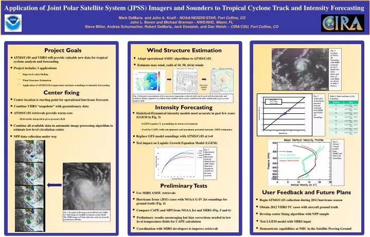
Application of Joint Polar Satellite System (JPSS) Imagers and Sounders to Tropical Cyclone Track and Intensity Forecasting Mark DeMaria and John A. Knaff- NOAA/NESDIS/STAR, Fort Collins, CO John L. Beven and Michael Brennan - NWS/NHC, Miami, FL Steve Miller, Andrea Schumacher, Robert DeMaria, Jack Dostalek, and Dan Welsh – CIRA/CSU, Fort Collins, CO Project Goals Fig. 4 Location of NOAA Jet Soundings with MIRS retrievals for the 8 flights into Irene. Dates and times of each flight are shown in Table 1 (below). Begin ATMS/CrIS collection during 2012 hurricane season Use MIRS AMSU retrievals Adapt operational AMSU algorithms to ATMS/CrIS ATMS/CrIS and VIIRS will provide valuable new data for tropical cyclone analysis and forecasting Estimate max wind, radii of 34, 50, 64 kt winds Hurricane Irene (2011) cases with NOAA G-IV Jet soundings for ground truth (Fig. 4) Obtain 2012 VIIRS TC cases with aircraft ground truth Statistical-Dynamical intensity models most accurate in past few years (LGEM in Fig. 3) Project includes 3 applications Develop center fixing algorithm with NPP sample • Improved center finding • Wind Structure Estimation • Application of ATMS/CrIS temperature moisture soundings to intensity forecasting Compare CAPE and MPI from NOAA Jet and MIRS (Fig. 5 and 6) • - LGEM requires T, q soundings in storm environment • - Used for CAPE (with entrainment) and maximum potential intensity (MPI) estimation Center fixing Replace GFS model soundings with ATMS/CrIS at t=0 Test impact on Logistic Growth Equation Model (LGEM) Center location is starting point for operational hurricane forecasts Fig. 2 Schematic representation of how microwave temperature retrievals (left) can be used with the hydrostatic and nonlinear balance equations to estimate winds (middle) which can be combined with other satellite data to give a wind analysis (left). Fig. 5 Scatter plot of maximum potential intensity estimated from MIRS and NOAA Jet Soundings. Table 1. Dates and times of Jet Soundings. Intensity Forecasting Combine VIIRS “snapshots” with geostationary data ATMS/CrIS retrievals provide warm core • - Hydrostatic integration gives pressure field Combine all available data in automatic image processing algorithm to estimate low-level circulation center NPP data collection under way Fig. 6 Vertical velocity profiles from MIIRS and NOAA Jet Soundings. Fig. 3 Operational Atlantic Hurricane Intensity Model Errors (2007-2011). Statistical Dynamical LGEM was the most accurate. Test LGEM model with MIRS input Preliminary results encouraging but bias corrections needed in low level temperature fields for CAPE calculation Demonstrate capabilities at NHC in the Satellite Proving Ground Wind Structure Estimation Coordination with MIRS developers to improve retrievals Preliminary Tests User Feedback and Future Plans Fig. 1 Example of IR imagery from MT-Sat and VIIRS low light image for landfall of tropical cyclone Heidi. The VIIRS image will help refine the center fix from the geostationary IR data. Geo IR Plus other satellite input