Download
1 / 91
910 likes | 1.1k Views
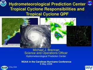
ANNUAL TROPICAL CYCLONE, DISASTER PREPAREDNESS & CLIMATE WORKSHOP. GUAM Chip Guard Warning Coordination Meteorologist Weather Forecast Office Guam. Purpose of the Workshop. Familiarize you with tropical cyclone hazards, characteristics, and behavior

E N D
ANNUAL TROPICAL CYCLONE, DISASTER PREPAREDNESS & CLIMATE WORKSHOP GUAM Chip Guard Warning Coordination Meteorologist Weather Forecast Office Guam
Purpose of the Workshop • Familiarize you with tropical cyclone hazards, characteristics, and behavior • Familiarize you with the tropical cyclone program and products for Guam • Discuss typhoon risks & vulnerabilities for Guam • Familiarize you with causes of weather around Guam • Familiarize you with other weather and ocean hazards, including rip currents, tsunamis, volcanoes • Familiarize you with Guam’s climate • Provide an opportunity for you to ask questions on weather- or climate-related topics
Tropical Cyclone Topics • Tropical Cyclone Characteristics, Behavior and Hazards • NWS Tropical Cyclone Program • NWS Tropical Cyclone Products • Timing of Products
Tropical Cyclone Characteristics • Tropical Cyclone Structure and Behavior • Hazards Associated with a Tropical Cyclone—The Triple Threat
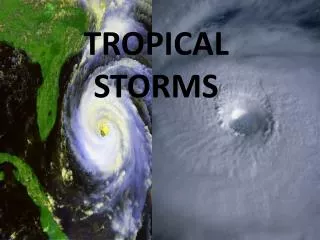
What Is A Tropical Cyclone? It’s a large area of clouds with a warm core low pressure center, which usually forms over tropical waters and has an organized circulation. It is like a pancake!
Stages of Tropical Cyclones • TROPICAL CYCLONE...a general term that includes tropical depressions, tropical storms, typhoons and super typhoons • TROPICAL DEPRESSION...a tropical cyclone with maximum sustained winds of 38 mph or less • TROPICAL STORM...a tropical cyclone with maximum sustained winds within the range 39 to 73 mph • TYPHOON...a tropical cyclone with maximum sustained winds of 74 mph or greater • SUPER TYPHOON...a typhoon with maximum sustained winds of 150 mph or greater
Necessary Ingredients • a pre-existing disturbance • warm ocean water...temperature at least 80 degrees F down to a depth of 150 ft • light upper level winds...little or no wind shear
THE TRIPLE THREAT • Winds • Storm surge and surf • Heavy rain producing floods and mudslides
stn pres ktmph 105(120) 29.770 wind dir 85(100) 29.495 pressure 70(80) 29.220 direction 50(60) 28.945 35(40) 28.670 17(20) 28.395 speed 0(0) 28.120 07 11 15 19 23 03 07 Winds: Sustained and Gusts
Tropical Cyclone Winds 150 ---1300feet Few People Live Here 700 feet-- Most People Live Here 15 feet----- Most tourists stay here
Wind Asymmetry Associated With Tropical Cyclones • “Right side of the storm" is defined with respect to the storm's motion: if the cyclone is moving to the west, the right side would be to the north of the storm; if the cyclone is moving to the north, the right side would be to the east of the storm, etc. • In general, the strongest winds are found on the right side of the cyclone because the motion of the cyclone also contributes to its swirling winds.
Wind Intensity and Distribution in a Tropical Cyclone • Strongest winds are located in right quadrant because of effect of speed of movement is added to wind distribution. (Likewise, winds are weaker in left quadrant because effect of the speed of movement is subtracted from the wind field. ) • Therefore, if cyclone passes south or west of island, then winds may be stronger than forecast. Or, if a cyclone passes north or east of island, then winds may be weaker than forecast.
(a) (b) 125 MPH 60 MPH 75 MPH 60 MPH 125 MPH 100 MPH 75 MPH 100 MPH 60 MPH 75 MPH 100 MPH 125 MPH 125 MPH (c) (d) 60 MPH 125 MPH 75 MPH 75 MPH 60 MPH 100 MPH 100 MPH Tropical Cyclone Wind Asymmetries
Wind Direction if a TC Passes North or East or North of Your Island Bay Ballot’s Law: Face into wind and low pressure is to your right (in the northern hemisphere) • If winds are from the NE, the TC is SE of island • If winds are from the N, the TC is E of island • If winds are from the NW, the TC is NE of island • If winds are from the W, the TC is N of island • If winds are from the SW, the TC is NW of island
Wind Direction if a TC Passes South or West of Your Island Bay Ballot’s Law: Face into wind and low pressure is to your right (in the northern hemisphere) • If winds are from the NE, the TC is SE of island • If winds are from the E, the TC is S of island • If winds are from the SE, the TC is SW of island • If winds are from the S, the TC is W of island • If winds are from the SW, the TC is NW of island
HIGH SEAS—Small Craft Stay in Port!!!!Inter-Island Travel is Dangerous!!!! Guam
STORM SURGE • Storm surge is the increase is sea height above the normal tide level, caused by the tropical cyclone’s low pressure and strong winds. • Low pressure component...1.5 ft elevation per 50 mb drop in pressure • Wind component…strong winds cause water to pile up in the right front quadrant. • Inundation is the water that penetrates into normally dry land. Depends on speed and duration of the wind; TC size, speed of motion; shape of coast, slope of bottom, width of the reef; and tidal state (high or low) are all important. The storm surge plus the tide is the storm tide.
Heavy Rainfall • Rainfall produced by cyclones can be highly variable • Amounts depend on the size of the storm, the speed at which it is moving, and the location of its rain bands • Typically 6 to 12 inches of rain can fall as a storm passes • Rain rates can be 6+ inches per hour, 20+ inches total • Coastal flooding will occur when the ocean level is elevated and rain cannot flow back to the sea • Flash flooding many occur as streams and rivers overflow • Mudslides may result due to saturated soils and wind stress on trees and foliage
Heavy Rainfall Producing Floods and Flash Floods Heavy rains are rapidly directed to the base of the mountain causing flash floods Elevated sea levels prevent rains from draining to the sea causing coastal flooding
Heavy Rainfall Contributes to Coastal Flooding and Inland Flooding
Heavy Rainfall Producing Mudslides • Estimated Critical Parameters • ~ 15” rain falls in 36 hours • continued 1” per hour rain • We Will Issue a Special Weather Statement for Mudslides When: • ~ 10” rain falls in 36 hours or less • rainfall greater than 0.50” per hour is expected to continue
Heavy Rainfall Producing Mudslides • Most Vulnerable Areas • where a slide occurred before, but bedrock is not exposed • the steeper areas made of clay • where vegetation has been removed
How Do Tropical Cyclones Get Named? • JTWC used to name them • Now the World Meteorological Organization names them through the Japan Meteorological Agency • Five lists of names taken from 12 countries • Does anyone know the Chamorro names?
How Do Tropical Cyclones Get Named? • Does anyone know the Chamorro names? • Roke, Francisco, Maria, Vicente
WEATHER FORECAST OFFICE (WFO) GUAM’S TROPICAL CYCLONE PROGRAM FOR GUAM
TROPICAL CYCLONEPROGRAM • Tropical cyclone watch and warning procedures • Tropical cyclone program products/messages • Products schedule
Warning Process • Starts with the Products of the Joint Typhoon Warning Center in Hawaii • Weather Service Forecast Office in Guam Analyzes JTWC Products and Issues Watches and Warnings • Weather Forecast Office Guam Notifies Guam Civil Defense
Warning Process Homeland Security/Office ofCivil Defense Works with the Governor’s Office to set CORs
Warning Process Civil Defense informs the general public and government agencies, and provides preparedness instructions
Joint Typhoon Warning Center (JTWC): • Located at Pearl Harbor, Hawaii; area of responsibility is 110 million square miles • Consists of a team of Navy and Air Force meteorologists who use numerous tools to analyze TC location, intensity and wind distribution, and computer models to help predict the future movement • JTWC responsible for all US tropical cyclone forecasting in the Northwest Pacific
Joint Typhoon Warning Center (JTWC): • Monitors region for developing tropical weather systems—Significant Tropical Weather Advisory • Alerts that systems are showing the potential for development into SIGNIFICANT tropical cyclones within the next 12 to 24 hours—Tropical Cyclone Formation Alert • Issues track and intensity forecasts for all tropical cyclones (30 mph and stronger) in the region—Tropical Cyclone Warnings
NWS WFO Guam: • Monitors Area of Responsibility (AOR) for weather systems showing signs of developing into tropical cyclones—Satellite Interpretation Message. • Maintains direct communications with JTWC regarding these areas of disturbed weather. • Will issue Special Weather Statements to cover areas not yet warned on by JTWC. We may change to a Tropical Disturbance Advisory