Download
1 / 16
160 likes | 273 Views
a. FY12-13 GIMPAP Project Proposal Title Page version 04 August 2011. Title : Developing GOES-Based Tropical Cyclone Recurvature Tools Status : New Duration : 2 years Project Leads: John Knaff NESDIS/ StAR –RAMMB John.Knaff@noaa.gov

E N D
a. FY12-13 GIMPAP Project Proposal Title Pageversion 04 August 2011 Title: Developing GOES-Based Tropical Cyclone Recurvature Tools Status: New Duration: 2 years Project Leads: John Knaff NESDIS/StAR –RAMMB John.Knaff@noaa.gov Mark DeMaria NESDIS/StAR–RAMMB Mark.DeMaria@noaa.gov Other Participants: Andrea Schumacher CIRA/CSU Ed FukadaUSN/Joint Typhoon Warning Center Chris LandseaNOAA/National Hurricane Center
b. Project Summary Construct a GOES-based product that estimates the short-term (0-48 hours) timing of TC recurvature for • North Atlantic and • Northwest Pacific TC basins • Where the point of recurvature is defined by the point along the track at which the meridional motion is poleward and the zonal component of motion changes from westward to eastward. • By making uses of • GOES/MTSAT water vapor imagery • GFS analysis/forecast fields • Tropical cyclone databases • and by combining/leveraging objective and subjective methods described in Hodanish and Gray (1993) and Dvorak (1995), respectively
c. Motivation / Justification • Supports NOAA’s Mission and its Weather and Water strategic goal • Improved tropical cyclone track forecasts are a top NOAA/DOD priority. • Late Guidance: The most recent numerical track guidance is not available when the track forecasts are produced • Track changes are discrete in nature. • These short-term accelerations can be very important when tropical cyclones are affecting land areas. • The most difficult track forecasts often involve the timing of recurving tropical cyclones (TCs).
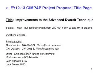
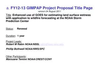
Positions (aircraft-based center locations ) Six-hourly best track positions Hurricane Earl (2010)
d. Methodology • Combine three data types (based on 2 older studies) • Tropical cyclone tracks/locations • Information in the GOES/GMS/MTSAT water vapor imagery (2001-2010) (cf. Dvorak (1995)) • Patterns associated with mid-latitude troughs • Distance from a tropical cyclone • Speed of the storm and approach of the trough • Information from the GFS/NCEP Reanalysis (cf. Hodanish and Gray (1993)) • Distance and direction of the westerly upper-level winds from the TC center • Depth of the upper-level westerlies • Forecasts of these fields
Dvorak (1995) Subjective Technique Water Vapor Imagery Curved Moisture Band (CMB) 1000 km (9o Latitude)
Basic findings : Hodanish and Gray (1993) • Recurvature is preceded by increases in or occurrence of • 500 and 200-hPa zonal winds within 600 to 800 km west, northwest and north of the TC • 200-hPa meridional winds within 600 to 800 km northwest and north of the TC • An index constructed from these factors is related to the point of recurvature. • Real-timeTesting in the West Pacific showed promise
Brief Description of the Method • Determine what upper-level wind conditions are required for TC recurvature using historical data • Determine the relationships between upper-level winds (500-200 hPa) and water vapor imagery in historical TC recurvature events using common statistical techniques and assuming a perfect prog solution. (such information can augment the first few hours of the GFS forecasts when the model forecasts are 3-6 hours old) • Use GFS (or any other forecast model) forecasts and the water vapor imagery to produce probabilistic forecasts the timing of TC recurvature through 48 hours.
e. Expected Outcomes • A GOES product that produces a probabilistic forecast of the timing of TC recurvature.
e. Possible Path to Operations • If successful, GOES PSDI funding will be sought for implementation in operations. • Alternatively, this product could seek Joint Hurricane Testbed funding for transition.
f. Milestones (FY12) • Compile historical TC recurvature cases for Atlantic and West Pacific from the best tracks • Construct the storm relative WV data for those cases • Construct the NCEP reanalysis storm relative wind fields for those cases • Begin exploring the statistical relationships between the wind fields and water vapor features
f. Milestones (FY13) • Develop statistical relationships between the wind, water vapor features and the timing of recurvature in the storm relative framework • Develop probabilistic model for the timing of TC recurvature • Test the model on independent data. • Document in refereed journal
g. Spending Plan FY12 • FY12 $57,000 Total Project Budget • Total Grant to CIRA $ 51K • 40% FTE (CIRA Research Scientist) $ 49K • CIRA Travel - $ 2 K • Federal Travel • AMS tropical Conference Ponte Vedre, FL April 2012 $ 3K • Federal Publication Charges – $ 3K
g. Spending Plan FY13 • FY13 $57,000 Total Project Budget • Total Grant to CIRA $ 51K • 40% FTE (CIRA Research Scientist) $ 49K • CIRA Travel - $ 2 K • Federal Travel • Trip to NRLMRY Monterey CA June 2013 $ 3K or Trip to JTWC, Pearl Harbor, HI • Federal Publication Charges – $ 3K