Download
1 / 1

E N D
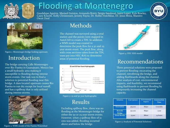
Methods Flooding at Montenegro The channel was surveyed using a total station and the points were mapped in AutoCAD to create a TIN. In addition, a WMS model was created to determine the peak flow for a 50 and 25 year storm event. The peak flow, along with cross sections taken from the TIN, were put into HEC-RAS to determine areas of potential flooding. Figure 1: Montenegro bridge looking upstream Figure 4: HEC-RAS model Introduction Recommendations Guadalupe Aguirre, Marisol Guintos, Armando Bravo, Sergio Sandoval, Jamir Lopez, Kyle Rowley, Casey Knecht, Kelly Christensen, Jeremy Payne, Dr. Rollin Hotchkiss, Dr. Jesus Mora, Maestro Oscar Dzul The bridge carrying Calle Montenegro over Rio Pastita in Guanajuato, Mexico has a small hydraulic area making it susceptible to flooding during intense storm events. Our task was to find a solution to potential flooding near this bridge. A dam located upstream causes Rio Pastita to run dry except for local runoff, and has a spillway that is only utilized during intense storms. Three potential solutions were proposed to prevent flooding: excavating the channel, retrofitting the bridge, and adding flashboards along the channel. After analysis of cost, environmental impacts, and feasibility, we recommend using flashboards to prevent flooding by temporarily increasing the channel capacity. Figure 3: 25 and 50 year hydrographs Results Excluding spillway flow, there was no flooding at the Montenegro bridge for either the 50 or 25 year storm events. However, when a spillway flow of 12 cms was added, flooding occurred above and below the bridge. Figure 5: Analysis of Potential Solutions Figure 2: WMS model of the Pastita Watershed