Download
1 / 16

E N D
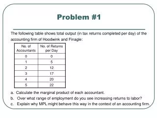
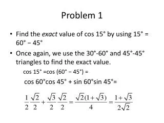
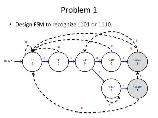
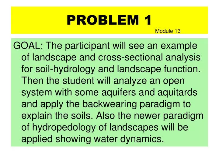
PROBLEM 1 Module 13 GOAL: The participant will see an example of landscape and cross-sectional analysis for soil-hydrology and landscape function. Then the student will analyze an open system with some aquifers and aquitards and apply the backwearing paradigm to explain the soils. Also the newer paradigm of hydropedology of landscapes will be applied showing water dynamics.
LANDSCAPES, WATER, SOILS: The next Generation of Soil Surveys? • Hudson, Berman D. 1992. The soil survey as a paradigm-based science. Soil Sci. Soc. Am J. 56:836-841. • “The soil-landscape model, on which soil survey is based, is an operative paradigm.” • “An extreme reliance on tacit knowledge, knowledge gained by experience, creates extreme inefficiencies….” • “Students and field soil scientists should be provided explicit instruction concerning the paradigm on which soil mapping and interpretation are based.”
LANDSCAPES, WATER, SOILS: The next Generation of Soil Surveys? • The basic premises of hydropedology are: • soil morphology is largely a function of • hydro-periodicity and water movement in • saturated and unsaturated flow conditions • in the soil across the entire landscape; • 2) oxidation and reduction combine with • dissolution, transport and precipitation of • soil constituents to cause volumes of • concentrations and depletions in soils • and landscape positions; and 3) soil morphology • can be used to interpret pathways of water • movement in landscapes.
LANDSCAPES, WATER, SOILS: The next Generation of Soil Surveys? COMBING THE PARADIGM OF LANDSCAPE SCALE HYDROPEDOLOGY WITH HUDSON’S SOIL LANDSCAPE PARADIGM YIELDS NEW PARADIGM POTENTIAL. NEW TOOLS PROVIDE THE MECHANISM: GIS GPS, LIDAR, & DEM CREATE VERY EXACTING LANDSCAPE REPLICATION. ADDING CLASSIC SOIL MORPHOLOGY INTREPRETATED FROM THE HYDROPEDOLOGY VIEW-POINT AND EXPANDING TO WHOLE LANDSACPE HYDROLOGY YIELDS A NEW SOIL-WATER SURVEY WITH VASTLY EXPANDED INTREPRTATION POTENTIAL. WITH PORTABLE IT EQUIPMENT, USERS CAN OBTAIN CURRENT THREE DIMENSIONAL EQUIPMENT AT REAL TIME IN THE FIELD. Such data can have overlayers of geology, biology, and other data.
Watershed study:Trout Run, Hardy co., WV • Purpose, location, background, etc. • Steps in analysis before site visit • Tools: Soil survey, topographic maps, Sketches, Cross-sections, soil descriptions from soil survey, landforms from soil mapping, finally after visiting the site-sketches of local areas. 1
Watershed study – Trout Run, in Hardy Co., West Virginia 2 Tools WSS, soil survey, and topographic maps & later geology maps
42 3
TRELLIS Drainage Pattern B F C E E F E C AND B slope soils on Erosional Footslope CL 5
LANDSCAPE SHAPE DYNAMIC EQUILIBRIUM J.T. HACK (Nikiforoff) BACK-WEARING R. V. RUHE MINIMUM ENERGY SLOPE L.D.MYER Toe Foot Back slope B C D F 6 Mlra 54 & 147
MLRA 147 Laidig Bucanan Bucanan wet Dekalb Tuscarora Juniata SS A and E Aquifer Bt Aquitard Aquifer below Bx Aquitard in shale bedrock Martinsburg Shale - added geology maps. 7
Generalized Map ViewLower Footslope (after field visit) Tributary V-shape Valley A A’ Colluvial Footslope Clarksburg Landform Toe- Slope Trout Run Channel Area 8
Cross-Section Clarksburg SEEP ZONE with some wetlands & mass-wastage A A’ Water Table 8” Dry Edge Small Creek Proposed Water table 9
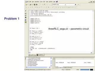
PROBLEM 1 APPANOOSE COUNTY, IOWA ORTHO PHOTO OF SEC. 36 BELLAIR TWP 933 222 222 312 211 222 312 222 10
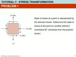
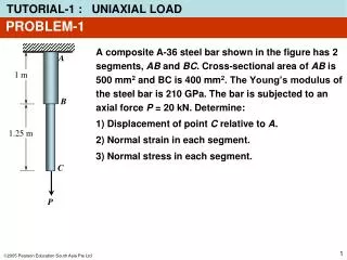
Btgb Bt PROBLEM 1 APPANOOSE COUNTY, IOWA CROSS-SECTION OF SEC. 36 BELLAIR TWP 222 HYDRIC? 211 Hydric? 933 312 Btg Very fine Bw E SiL18%C Clay (55%C) C 24% C 70%+ Loess Till 11
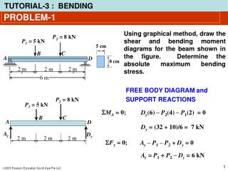
PROBLEM 1 933 222 312 211 12 • Create a cross-section that illustrates the four soils from the highest to the lowest. Sketch the profiles on yourlandscape (slope) profile. Where are the aquifers&aquitards? • Illustrate the hydrology with lines and arrows. Explain your flow lines. • Label recharge flowthrough and discharge areas. • Explain the soil distribution with stratigraphy & geomorphology. 50