Download
1 / 35
350 likes | 481 Views
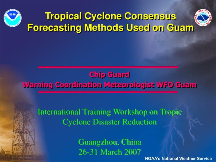
Tropical Cyclone Consensus Forecasting Methods Used on Guam. Chip Guard Warning Coordination Meteorologist WFO Guam. International Training Workshop on Tropic Cyclone Disaster Reduction Guangzhou, China 26-31 March 2007. NOAA’s National Weather Service. Consensus Forecasting Methods.

E N D
Tropical Cyclone Consensus Forecasting Methods Used on Guam Chip Guard Warning Coordination Meteorologist WFO Guam International Training Workshop on Tropic Cyclone Disaster Reduction Guangzhou, China 26-31 March 2007 NOAA’s National Weather Service
Consensus Forecasting Methods • What is Consensus Forecasting? • Consensus forecasting is the process of combining different types or sources of information into a solution that is hopefully better than any of the parts. • What is Tropical Cyclone Consensus Forecasting? • Tropical Cyclone consensus forecasting is the process of taking multiple sources of predictions and combining them into a track or intensity forecast that is better than any of the individual predictions (over a reasonable period of time, e.g., a season). This process can be automated. NOAA’s National Weather Service
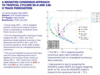
Consensus Forecasting Methods • Methods of Consensus Forecasting? • A consensus approach has been used by forecasters and forecast centers for decades—since the time when multiple forecast options became available to the centers. • In the 1990’s, the Joint Typhoon Warning Center began to automate the consensus process using several different methods: • Interpolation of model tracks • Single and multi-model methods • Weighted and non-weighted • Selective and non-selective • Position consensus vs. vector motion consensus (See Andrew Burton’s Paper from IWTC-VI) NOAA’s National Weather Service
Consensus Forecasting Methods • What Consensus Techniques do we use on Guam? • Our primary forecasts come from the Joint Typhoon Warning Center (JTWC), now located in Hawaii • Their track forecasts use the NOGAPS model to produce numerous ensemble forecasts from which their official forecast is derived • Ensembles forecasts are themselves consensus forecasts • We look at predictions from other forecast centers—many of these also derived from ensemble forecasts—and evaluate their performance with and deviations from the JTWC predictions • Usually our consensus is the forecast of the Joint Typhoon Warning Center……….but, how can we improve on that? NOAA’s National Weather Service
Consensus Forecasting Methods • We evaluate the initial information • Are the tropical cyclone fixes good? Can the spread be explained? • Are the Dvorak intensity estimates good? Can the spread be explained? • Is the initial motion vector good? We have found this to be the single most important reason why early model forecasts (first 24h) are wrong • We look at all the data—especially the satellite data—to reassess the initialization/input data • We evaluate the NOGAPS model against our National Weather Service models at the lower, middle and upper levels to assess similarities and differences NOAA’s National Weather Service
Consensus Forecasting Methods • We evaluate geography and climatology • Will there be local effects on the track? On the intensity? On the wind distribution and asymmetry? On the hazards? • What should we expect from climatology? Does the forecast exceed the bounds of climatology? If so, is there a physical explanation for this? • We Default to Radar Data When the Storm is Near • We carefully track the radar motion for short and long term trends • We use the Doppler to refine and validate storm intensity • We feed our assessments back to JTWC NOAA’s National Weather Service
Trochoidal Motion • USER BEWARE! • Short term variations may not be indicative of changes in overall motion of the tropical cyclone
Consensus Forecasting Methods • We evaluate the lower, middle and upper levels • Low-levels—analyze Quick SCAT data over our entire area and evaluate other satellite data, especially visual data if available; sunrise surprise • High resolution winds (8-min average, 25 km resolution); there is a tendency to under-estimate winds from data; concept of the minimum maximum • Reveals size of storm—important for • gales and storm-force winds; reflects pressure gradients • storm surge and coverage of damage • Beta effect on movement speed and down-stream development • Mid-levels—look for steering levels • 400-500 hPa for deep storms • 700-500 hPa for shallower storms (not common) • 850 hPa for sheared storms NOAA’s National Weather Service
Consensus Forecasting Methods • We evaluate the lower, middle and upper levels • Upper-levels—analyze 200 hPa level and satellite data • Analysis is at both the synoptic and meso scales • This level is important for intensity forecasts • Identify features and determine how well the models reflect those features; (e.g., cyclonic cells in the Tropical Upper Tropospheric Trough (TUTT) or outflow channels) • Assess shear and meso-scale interactions • We use microwave data to assess the vertical structure of the tropical cyclone NOAA’s National Weather Service
Consensus Forecasting Methods • Weighting techniques in track forecasting • Heavily weight the first 6-12 hours toward persistence • Thus, initial motion vector is VERY important • Heavily weight the overall forecast on JTWC. Why? • They do a good job as do most of the centers • We can easily discuss the forecasts with them and provide input and data • If we do change the JTWC forecast, it is as a last resort and only in the first 24 hours • We used to weight longer range forecasts toward climatology, but it is getting very difficult to beat the dynamic models for track forecasts • Look for bifurcations; convey the alternatives to your Emergency Mgr; timing of the turns can be critical • We also use the models (out to 7 days) to assess genesis potential; we combine this knowledge with the MJO predictions and ENSO status NOAA’s National Weather Service
Consensus Forecasting Methods • Weighting techniques in intensity forecasting • Look for areas of shear • Look for meso-scale interactions • Favorable for rapid intensification • TUTT cell 10-12º from cyclone center • TUTT cell center NNW of cyclone center • Multiple outflow channels • Unfavorable • TUTT cell within 8° of cyclone center • Single outflow channel • Kinks in outflow • Assess output from intensity forecast models NOAA’s National Weather Service
Consensus Forecasting Methods • Hints for Success in preventing disasters • Go with persistence in the short term • Don’t assume; pick up the phone and make sure • Be proactive; pick up the phone first and make sure • Go after data; don’t wait for it to come to you • Develop good satellite interpretation skills; there is up to 36 hours of predictive value in satellite imagery • It is better to over-forecast than to under-forecast • Anticipate what could go wrong; communicate concerns or options with the Emergency Manager NOAA’s National Weather Service
Consensus Forecasting Methods • Hints for Success in Preventing Disasters • Use the triad of partners: Met/Hydro Services, Emergency Managers, Media; the public doesn’t care who messed up, they just know the Government messed up; perception is reality • No one should know more about the storm than you do • Know the geography, climatology, risks and vulnerabilities: It’s free knowledge • Keep products and information simple; you are talking to customers, not meteorologists • Forecast within your capabilities and expertise • Develop an in-house forecast strategy for every storm or event NOAA’s National Weather Service
Questions Our Anatahan Volcano NOAA’s National Weather Service
Volcano Hazards for Guam Guam Guam Palau Palau Anatahan Anatahan NOAA’s National Weather Service
Volcano Hazards for Guam NOAA’s National Weather Service
Volcano Hazards for Guam Pagan Anatahan NOAA’s National Weather Service
Volcano Hazards for Guam Pagan Island from Space Shuttle NOAA’s National Weather Service
Volcano Hazards for Guam Hawaii Anatahan NOAA’s National Weather Service
Volcano Hazards for Guam Anatahan Anatahan NOAA’s National Weather Service
Volcano Hazards for Guam NOAA’s National Weather Service
Volcano Hazards for Guam NOAA’s National Weather Service
Volcano Hazards for Guam NOAA’s National Weather Service
Volcano Hazards for Guam Ahyi NW Rota 1 NOAA’s National Weather Service
Volcano Hazards for Guam New Britain,PNG NOAA’s National Weather Service
Volcano Hazards for Guam Rabaul, PNG NOAA’s National Weather Service
Volcano Hazards for Guam Pinatubo, Philippines NOAA’s National Weather Service
Volcano Hazards for Guam Galunggung, Indonesia NOAA’s National Weather Service
Volcano Hazards for Guam Ruang, Indonesia NOAA’s National Weather Service
Volcano Hazards for Guam Reventador, Ecuador (not a hazard for Guam) NOAA’s National Weather Service
Prognosis for Anatahan Eruption • Lava extrusion and small explosions inside the E crater, and discontinuous low level ash eruption • Hazards limited to island and to local aviation • “Open conduit “ for now, but situation can change quickly • Larger explosive eruption(s) accompanied by large eruptive column and pyroclastic flows • Ash cloud hazards more widespread and severe; small chance of local tsunami from pyroclastic flows entering the sea or from flank landslides into sea • Very large explosive eruption w/ caldera formation (e.g. Pinatubo), &/or large landslide (e.g. Mount St. Helens) • Major threat to aviation in case of explosive eruption • Tsunami generation, Marianas-wide effects At Present Possible Unlikely
Volcanic Ash – threat to Guam Volcanoes in the Mariana Islands could produce volcanic ash on Guam. Wet ash conducts electricity; can cause short circuits. Weight of ash (especially wet) can cause roof collapse. Ash can clog ventilation and drainage systems. Ash causes wear on moving parts of machinery. Ash makes roads slippery. Ash is a serious hazard to aviation Ash can cause respiratory problems.
Volcanic Haze (VOG)– can affect Guam Concentration of gases over Guam is usually very low The haze/dust can cause breathing difficulties for some people; they should stay indoors Haze can cause acid rain; Guam is largely calcium carbonate, which would neutralize the acid. Haze can obscure mountains and reduce visability. Not a serious corrosion hazard to aviation.
VOG – The good & bad news Prevailing winds tend to transport vog and ash toward the west and southwest, away from Guam; NNE wind bad for Guam. Topographic traps for vog are not significant in Guam. Trade Winds Geology of Guam is dominated by carbonate, which will neutralize acid rain.