Download
1 / 17
170 likes | 172 Views
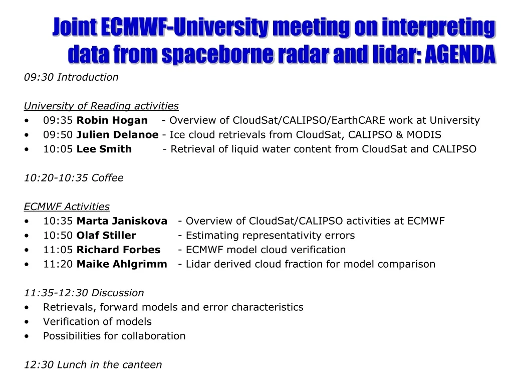
Joint ECMWF-University meeting on interpreting data from spaceborne radar and lidar : AGENDA. 09:30 Introduction University of Reading activities 09:35 Robin Hogan - Overview of CloudSat/CALIPSO/EarthCARE work at University

E N D
Joint ECMWF-University meeting on interpreting data from spaceborne radar and lidar: AGENDA 09:30 Introduction University of Reading activities • 09:35 Robin Hogan - Overview of CloudSat/CALIPSO/EarthCARE work at University • 09:50 Julien Delanoe - Ice cloud retrievals from CloudSat, CALIPSO & MODIS • 10:05 Lee Smith - Retrieval of liquid water content from CloudSat and CALIPSO 10:20-10:35 Coffee ECMWF Activities • 10:35 Marta Janiskova - Overview of CloudSat/CALIPSO activities at ECMWF • 10:50 Olaf Stiller - Estimating representativity errors • 11:05 Richard Forbes - ECMWF model cloud verification • 11:20 Maike Ahlgrimm - Lidar derived cloud fraction for model comparison 11:35-12:30 Discussion • Retrievals, forward models and error characteristics • Verification of models • Possibilities for collaboration 12:30 Lunch in the canteen
Recent CloudSat/CALIPSO/EarthCARE-related work at University of Reading • Forward models and model evaluation • Lidar forward modelling to evaluate the ECMWF model from IceSAT • Multiple scattering model for spaceborne radar and lidar (Hogan) • Retrievals and model evaluation • LITE lidar estimates of supercooled water occurrence • Radar retrievals of liquid clouds (Lee Smith, Anthony Illingworth) • Variational radar-lidar-radiometer retrieval of ice clouds (Delanoe) • ESA “CASPER” project (Clouds and Aerosol Synergy Products from EarthCARE Retrievals) • Defined the required cloud, aerosol and precipitation products • Developed variational ice cloud retrieval for EarthCARE that uses the cloud radar, the “High Spectral Resolution Lidar” (HSRL; the same technology as ADM) and the infrared channels of the multispectral imager
Ongoing/future work Forward models and model evaluation • Use the CloudSat simulator to evaluate the 90-km resolution HiGEM version of the Met Office climate model (Margaret Woodage) • Use the CloudSat simulator to evaluate 1-km large-domain simulations of tropical clouds in “CASCADE” (Thorwald Stein) Retrievals and model evaluation • Ongoing comparisons with MO and ECMWF models (Smith & Delanoe) • Use of retrievals to evaluate the CASCADE model (Thorwald Stein) CloudSat, CALIPSO and EarthCARE algorithm development • Develop a “unified” retrieval algorithm for clouds, precipitation and aerosols simultaneously using radar, lidar, infrared radiances and possibly microwave radiances (Nicola Pounder, Hogan, Delanoe) Science questions • What is the radiative impact of errors in model clouds? Use retrievals, CERES observations and radiative transfer calcs. (Nicky Chalmers) • What is the distribution of supercooled water in the atmosphere and why is it so difficult to model? (Andrew Barrett)
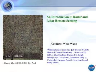
ECMWF clouds vs IceSAT using a lidar forward model Wilkinson, Hogan, Illingworth and Benedetti (Monthly Weather Review 2008) • Cloud observations from IceSAT 0.5-micron lidar (first data Feb 2004) • Global coverage but lidar attenuated by thick clouds: direct model comparison difficult Lidar apparent backscatter coefficient (m-1 sr-1) Latitude Optically thick liquid cloud obscures view of any clouds beneath • Solution: forward-model the measurements (including attenuation) using the ECMWF variables
ECMWF cloud fraction after processing IceSAT cloud fraction ECMWF raw cloud fraction Simulate lidar backscatter: • Create subcolumns with max-rand overlap • Forward-model lidar backscatter from ECMWF water content & particle size • Remove signals below lidar sensitivity
Global cloud fraction comparison • Results for October 2003 • Tropical convection peaks too high • Too much polar cloud • Elsewhere agreement is good • Results can be ambiguous • An apparent low cloud underestimate could be a real error, or could be due to high cloud above being too thick ECMWF raw cloud fraction ECMWF processed cloud fraction IceSAT cloud fraction
Examples of multiple scattering Stratocumulus Surface echo Apparent echo from below the surface Intense thunderstorm • LITE lidar (l<r, footprint~1 km) CloudSat radar (l>r)
Fast multiple scattering forward model Hogan and Battaglia (J. Atmos. Sci. 2008) • New method uses the time-dependent two-stream approximation • Agrees with Monte Carlo but ~107 times faster (~3 ms) • Added to CloudSat simulator CloudSat-like example CALIPSO-like example
Combining radar and lidar… Radar misses a significant amount of ice Global-mean cloud fraction Radar and lidar Radar only Lidar only Cloudsat radar CALIPSO lidar Insects Aerosol Rain Supercooled liquid cloud Warm liquid cloud Ice and supercooled liquid Ice Clear No ice/rain but possibly liquid Ground Preliminary target classification
“Unified” retrieval framework New ray of data: define state vector Use classification to specify variables describing each species at each gate • Ice:extinction coefficient and N0* • Liquid: liquid water content and number concentration • Rain: rain rate and mean drop diameter • Aerosol: extinction coefficient and particle size (Black) Ingredients already developed (Delanoe and Hogan JGR 2008) (Red) Ingredients remaining to be developed Radar model Including surface return and multiple scattering Lidar model Including HSRL channels and multiple scattering Radiance model Solar and IR channels Forward model Compare to observations Check for convergence Not converged Gauss-Newton iteration Derive a new state vector Converged Proceed to next ray of data
Mixed-phase clouds Two independent methods from MODIS show the same thing • Supercooled water layers have large radiative impact • Poorly modelled LITE lidar showed more supercooled water in SH than NH Hogan et al. (GRL 2004) What does CALIPSO show? What is the explanation? How can we model mixed-phase clouds?
Discussion points • Is the intention to assimilate cloud radar and lidar directly? • If so, are fast radar and lidar forward models of interest? • If retrievals are to be assimilated, what variables are needed? • Do you need error covariances, averaging kernels and information content? Straightforward to calculate, but: • Complicated to store (state vector is a different size for each profile) • Increases the data volume by an order of magnitude • What are best diagnostics for assessing model performance? • Means, PDFs, skill scores… • ECMWF model variables are required by retrievals • What is the error of model temperature, pressure and humidity?
CloudSat simulator (Bodas et al) • Simulated radar reflectivity from sub-grid model • Simulated radar reflectivity averaged to model grid • How would this look with high-res model? • Observed CloudSat radar reflectivity
Example of mid-Pacific convection MODIS 11 micron channel Retrieved extinction (m-1) CloudSat radar Deep convection penetrated only by radar Height (km) CALIPSO lidar Cirrus detected only by lidar Height (km) Mid-level liquid clouds Time since start of orbit (s)
Supercooled water in models • A year of data from the Met Office and ECMWF • Easy to calculate occurrence of supercooled water with > 0.7 Prognostic ice and liquid+vapour variables Prognostic cloud water: ice/liquid diagnosed from temperature