Download
1 / 36
360 likes | 487 Views
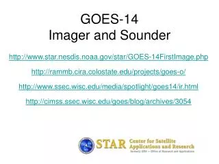
GOES-14 Imager and Sounder. Timothy J. Schmit NOAA/NESDIS/Satellite Applications and Research Advanced Satellite Products Branch (ASPB) Mathew M. Gunshor, Tony Schreiner, Scott Bachmeier, Joleen Feltz, Steve Wanzong, SSEC Data Center, etc. CIMSS/SSEC, Madison, WI. a preliminary look.

E N D
GOES-14Imager and Sounder Timothy J. Schmit NOAA/NESDIS/Satellite Applications and Research Advanced Satellite Products Branch (ASPB) Mathew M. Gunshor, Tony Schreiner, Scott Bachmeier, Joleen Feltz, Steve Wanzong, SSEC Data Center, etc. CIMSS/SSEC, Madison, WI a preliminary look Don Hillger and Tim Schmit co-lead the NOAA Science Test
Outline • Introduction • First imager and sounder images • Issues • Comparisons • Improved imager band 6 (13.3 um) spatial resolution • Preliminary inter-calibration results • Improved INR and Operation thru eclipse • Initial products (imager and sounder) • Web links
GOES-14 GOES-13/14/P have similar instruments to GOES-8-12, but on a different spacecraft bus. Spring and fall eclipse outages will be avoided by larger onboard batteries. Improved navigation Improved radiometrics GOES-8/12 GOES-13/14/P
von Karman vorticies GOES-14 • GOES-O Science Test web page: http://rammb.cira.colostate.edu/projects/goes-o/
sediment plume vortex in the marine layer clouds , snow Amazon suppressing the formation of cumulus actinoform clouds
Noted several issue with initial GOES-14 data GOES-14 Imager • Important diagnostic work was under-taken. After an issue was raised dealing with the data stream of imager band 6, the suggested fix was implemented at the ground station. Many groups, both within NOAA/NESDIS, the Cooperative Institutes, NASA and others, quickly worked together to fix this issue. Erroneous line headers of the GOES-14 Imager bands 3 and 6 (the 6.5 and 13.3 um) in the first official full disk images. The first two official full disk images were ‘too wide’ and hence displayed ‘extra’ header information within the frame of data. Sponsor: OSD G-PSDI Program
Noted several issue with initial GOES-14 data GOES-12 Imager GOES-14 Imager (before fix) • Important diagnostic work was under-taken. After an issue was raised dealing with the data stream of imager band 6 (13.3 um) , the suggested fix was implemented at the ground station. Many groups, both within NOAA/NESDIS, the Cooperative Institutes, NASA and others, quickly worked together to fix this issue. Note the artificial ‘stair-step’ of cloud edges due to the detectors initially being out of order in GVAR. Erroneous detector flip of the GOES-14 Imager band 6 (the 13.3 um) in the first IR images. Another issue was the ‘flipped’ order of the band 6 of the GOES-14 imager in the GVAR datastream. This was communicated, corrected and verified. Sponsor: OSD G-PSDI Program
First GOES-14 Imager and Sounder images H • On August 17th and 18th, the first official Geostationary Operational Environmental Satellite (GOES)-14 infrared (IR) images were scanned. • Qualitatively, the data from the Imager and Sounder are high quality, with improved signal-to-noise ratios compared to other operating GOES satellites. • The NOAA Science test will begin in December of 2009. First GOES-14 Imager data on August 17, 2009 First GOES-14 Sounder data on August 18, 2009 The first GOES-14 Imager and Sounder images look to be of high quality, this is the first step for the subsequent NOAA science test check-out. Sponsor: OSD G-PSDI Program (Courtesy of T. Schmit)
First GOES-14 Images (sub-sampled) Note the ‘brighter’ GOES-14 visible image From NOAA ASPB
GOES-12 (for comparison) Note the sub-satellite points are different From NOAA ASPB
GOES-14 Sounder! Note clean signal, especially bands 1, 2, 12 and 15.
GOES-12 Sounder Data has been remapped to a common projection.
River Fog GOES-14 GOES-12 The fog is a bit brighter and a little more extensive in the GOES-14 image. GOES-14 is able to discern urban centers more readily than GOES-12.
Improved spatial resolution of GOES-14 Imager band 6 H GOES-14 GOES-12 • The improved spatial resolution of the Geostationary Operational Environmental Satellites (GOES)-14 imager band 6 has been verified. This band, centered at 13.3 um, has a number of uses, the main being cloud height determination. • Important diagnostic work was under-taken. After an issue was raised dealing with the data stream of imager band 6, the suggested fix was implemented at the ground station. Many groups, both within NOAA/NESDIS, the Cooperative Institutes, NASA and others, quickly worked together to fix this issue. The 13.3 um band 6 of the GOES-12 (left panel) has an 8 km IGFOV (Instantaneous Geometric Field of View); while the same band on the GOES-14 (right panel) has a 4 km IGFOV. Note the finer resolution of the cloud edges and the ‘cleaner’ image. The improved spatial resolution of the GOES-14 imager band 6 (over GOES-12/13 imagers) has been verified with initial on-orbit data. Sponsor: OSD G-PSDI Program (Courtesy of T. Schmit)
Methodology: GEO – IASI Intercal • Collocation in time and space. • Within 30 minutes at geostationary subpoint (GSNO – Geostationary Simultaneous Nadir Observation) • Low Satellite View Angles (< 14) • Spatial smoothing • 100km “running average” mitigates the negative effects of poor spatial and temporal collocation, poor navigation, and spatial resolution differences. • Average radiances, not temperatures. • Compare a common area around the GEO sub-point, not “pixel to pixel” comparisons • “Convolve” high spectral resolution Radiance spectra with GEO Spectral Response Function. • Compare mean scene brightness temperatures (converted from mean scene radiances).
Preliminary intercalibration results with GOES-14 Imager using IASI • Mean temperature differences with IASI (for 12 cases) are: • -0.4 K for the Shortwave Window band (5 night cases) • +0.8 K for the Water Vapor band • +0.1 K for the IR Window band • -0.6 K for the CO2 Absorption band • The CO2 band SRF may be updated before the science test takes place. • Some of these results may include cases where navigation was not optimal.
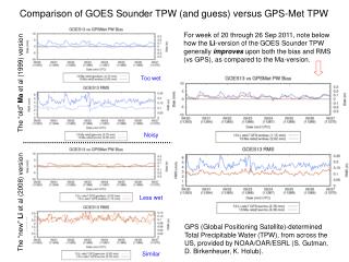
GOES Series Sounder Noise GOES-14 – the best Sounder yet wrt noise performance! Units: mW/(m2 ster cm-1) Preliminary
Visible GOES-14; SNR of 33:1 GOES-12; SNR of 13:1
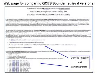
GOES-14Imager and Sounder http://rammb.cira.colostate.edu/projects/goes-o/ http://www.star.nesdis.noaa.gov/star/GOES-14FirstImage.php http://www.ssec.wisc.edu/media/spotlight/goes14/ir.html http://cimss.ssec.wisc.edu/goes/blog/archives/3054 http://www.ssec.wisc.edu/data/geo/index.php?satellite=goes14&file=jpg http://cimss.ssec.wisc.edu/goes/rt/sounder-dpi.php