Download
1 / 20
200 likes | 348 Views
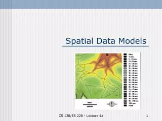
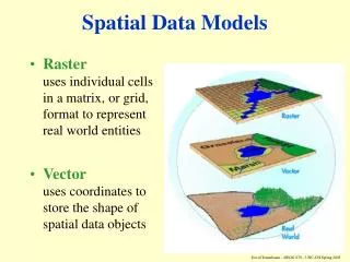
Spatial Data Models. What is a Data Model?. What is a model? (Dictionary meaning) A set of plans (blueprint drawing) for a building A miniature representation of a system to analyze properties of interest What is Data Model? Specify structure or schema of a data set

E N D
What is a Data Model? • What is a model? (Dictionary meaning) • A set of plans (blueprint drawing) for a building • A miniature representation of a system to analyze properties of interest • What is Data Model? • Specify structure or schema of a data set • Document description of data • Facilitates early analysis of some properties, e.g. querying ability, redundancy, consistency, storage space requirements, etc. • Examples: • GIS organize spatial set as a set of layers • Databases organize dataset as a collection of tables
Why Data Models? • Data models facilitate • Early analysis of properties, e.g. storage cost, querying ability, ... • Reuse of shared data among multiple applications • Exchange of data across organization • Conversion of data to new software / environment • Example- Y2K crisis for year 2000 • Many computer software systems were developed without well-defined data models in 1960s and 1970s. These systems used a variety of data models for representing time and date. Some of the representations used two digits to represent years.
Types of Data Models • Two Types of data models • Generic data models • Developed for business data processing • Support simple abstract data types (ADTs), e.g. numbers, strings, date • Not convenient for spatial ADTs, e.g. polygons • Recall a polygon becomes dozens of rows in 3 tables • Need to extend with spatial concepts, e.g. ADTs • Application Domain specific, e.g. spatial models • Set of concepts developed in Geographic Info. Science • Common spatial ADTs across different GIS applications • Plan of Study • First study concepts in spatial models • Then study generic model • Finally put the two together
Understand the models of spatial information Field based model Object based model
State-Park SDB: consists of forests – different species of tree Spatial Data Modelling • Two common models • Object based • Field based (functional model) • Example: Forest stands • (a) forest stand map • (b) Object view has 3 polygons • (c ) Field view has a function Homogeneous areas: each with one tree species
2.1.1 Field based Model • Field models often used to model continuous spatial trends such as elevation, temperature, and soil variation. • Object models are more common in modeling transportation networks (e.g., roads), land parcels and legal ownership-related applications • Three main concepts: • Spatial Framework is a partitioning of space • e.g., Grid imposed by Latitude and Longitude • Field Functions: f: Spatial Framework Attribute Domain • Field Operations • Examples, addition(+) and composition(o).
Types of Field Operations • Field operations • Local: value of the input field at specific location • Focal: value depends on the input field assuming in a small neighborhood of the location. Ex. Limit operation • Zonal: aggregate or integration functions. Ex. Avg values • Exercise: Classify following operations on elevation field • (I) Identify peaks (points higher than its neighbors) • (II) Identify mountain ranges (elevation over 2000 feet) • (III) Determine average elevation of a set of river basins
2.1.2 Object Model • Object model concepts • Objects: distinct identifiable things relevant to an application • Objects have attributes and operations • Attribute: a simple (e.g. numeric, string) property of an object • Operations: function maps object attributes to other objects • Example from a roadmap • Objects: roads, landmarks, ... • Attributes of road objects: • spatial: location, e.g. polygon boundary of land-parcel • non-spatial: name (e.g. Route 66), type (e.g. interstate, residential street), number of lanes, speed limit, … • Operations on road objects: determine length, determine intersection with other roads, ...
Classifying Spatial objects • Spatial objects are spatial attributes of general objects • Spatial objects are of many types • Simple • 0- dimensional (points), 1 dimensional (curves), 2 dimensional (surfaces) • Example given at the bottom of this slide • Collections • Polygon collection (e.g. boundary of Japan or Hawaii), …
Classifying Operations on spatial objects in Object Model Remember field based operations: local, focal, zonal • Classifying operations • Set based: 2-dimensional spatial objects (e.g. polygons) are sets of points • a set operation (e.g. intersection) of 2 polygons produce another polygon • Topological operations: Boundary of USA touches boundary of Canada • Directional: New York city is to east of Chicago • Metric: Chicago is about 700 miles from New York city. • Q? Identify classes of spatial operations not listed in this slide.
[ SLAYT ] Spatial Object Types in OGIS Data Model Each rectangle shows a distinct spatial object type 2-dim geometry Collection of islands Collection of oil wells
Spatial Types – OGC Simple Features for SQL Composed Sub Type SpatialReferenceSystem Geometry Relationship GeometryCollection Point Curve Surface Polygon MultiSurface MultiCurve MultiPoint LineString Line LinearRing MultiPolygon MultiLineString
Spatial Data Types • The most general shape is represented by geometry • Point: city centers (0-dim) • Curve: rivers (1-dim) • Curve objects are often approximated by a linestring • Surface: country (2-dim) • Surface objects are often approximated by a polygon • Geometry collections • This type provide a “closure” property to OGC spatial data types under geometric operations such as “geometric-union”, “geometric-difference” or “geometric-intersection”
Topological Relationships • Topological Relationships • invariant under elastic deformation (without tear, merge). • Two countries which touch each other in a planar paper map will continue to do so in spherical globe maps. • Adjacency of two-polygons remains intact • Topology is the study of topological relationships • Is the area of a polygon topological property (no) • Why? : the relative areas of different countries are often not preserved in many maps
Green is A interior Red is boundary of A Blue –(Green + Red) is A exterior Topological Concepts • Interior, boundary, exterior • Let A be an object in a “Universe” U. U A • Question: Define Interior, boundary, exterior on curves and points.
Nine-Intersection Model of Topological Relationships • Many toplogical Relationship between A and B can be • specified using 9 intersection model • Examples on next slide • Nine intersections • intersections between interior, boundary, exterior of A, B • A and B are spatial objects in a two dimensional plane. • Can be arranged as a 3 by 3 matrix • Matrix element take a value of 0 (false) or 1 (true). • Q? Determine the number of many distinct 3 by 3 boolean matrices .
[ SLAYT ] Specifying topological operation in 9-Intersection Model Fig 2.3: 9 intersection matrices for a few topological operations Question: Can this model specify topological operation between a polygon and a curve?