Download
1 / 89
1.13k likes | 2.33k Views
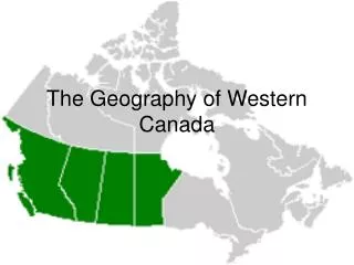
GEOGRAPHY OF CANADA. Social Studies 10 Chapter 3 & 8 Canadian Geography & Economy. CANADA: A REGIONAL GEOGRAPHY What regions are evident?. Physical Regions. Economic Regions. Climate. Political Regions. Five Themes of C anada’s G eography. Location: relative and absolute

E N D
GEOGRAPHY OF CANADA Social Studies 10 Chapter 3 & 8 Canadian Geography & Economy
Five Themes of Canada’s Geography • Location: relative and absolute • Place: human and physical • Human and Environment Interactions: adaptation, modification, dependence • Movement: migration and transportation • Regions: consistent, focused, aligned, linked
Theme 1: Location • Two Types of Location • Absolute • Relative • Where is It? • Why is It There?
Absolute Location • A specific place on the Earth’s surface • Uses a grid system • Latitude and longitude • A global address
British Columbia Absolute Location • BC 54° N Latitude 125° W longitude • Vancouver 49° 25' N Latitude 123° 10' W Longitude
Relative Location • Where a place is in relation to another place • Uses directional words to describe • Cardinal and intermediate directions
British Columbia • British Columbia is bordered by Yukon in the north, Washington and Idaho tothe south, and Alberta on the west. • The Pacific Ocean forms British Columbia's west coast. • British Columbia is one of the western provinces
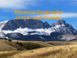
Theme 2: PlacePhysical Characteristics • Land Features • Mountains, plains, and plateaus • Climate • Bodies of Water
British Columbia: Physical Characteristics Photos above: Steve Pierce http://www.wetmaap.org/Cape_Hatteras/ch_tm_2.html
Theme 2: PlaceHuman Characteristics • People • Culture • Language • Religion • Buildings and Landmarks • Cities
British Columbia: Human Characteristics http://www.rivinus.com/camerastuff/charlotte_nc.htm National Geographic Magazine Top right:http://graphics.fansonly.com/photos/schools/unc/nonsport/school-bio/unc-oldwell2-lg.jpg
Theme 3: Human Environment Interaction How People Interact With Their Environment People . . . • Adapt to Their Environment • Modify Their Environment • Depend on Their Environment http://www.fotosearch.com/comp/corbis/DGT119/BAG0017.jpg
British Columbia: Human Environment Interaction http://aam.wcu.edu/grant/images/Fontana%20Dam%20Shirley.jpg http://www.dukemagazine.duke.edu/dukemag/issues/091002/images/mallc.jpg http://www.ee.duke.edu/~sag8/Duke/02-03/PiKA/Fall%20Break/Fall_Break_02.htm
Theme 4: Movement The Mobility of • People • Goods • Ideas How Places are linked to one another and the world
British Columbia: Movement http://www.marad.dot.gov/Gallery/MoreheadCity/pages/Ming%20Europe.htm http://www.evertize.com/land/images/I-40-64%20interchange.JPG
Theme 5: Regions What Places Have in Common • Political Regions • Landform Regions • Agricultural Regions • Cultural Regions
British Columbia: Regions Steve Pierce http://home.neo.rr.com/rodsphotogallery/NaturalWonders/SeaSand/Images/JockeysRidge.jpg http://www.ncbbi.org/images/piedmont-images/piedmont-nc-heartland-golf.jpg http://www.homestead.com/pncfa/files/piedmontmap.jpg http://www.shorebirdworld.org/fromthefield/Images/Hatteras%20Light.JPG
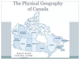
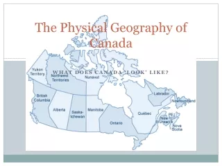
Divisions and Places Placing the Canadian map Political divisions: provinces and territories
Fundamentals of Physical Geography • Geology-process, structure, time • Topography-relief, slope • Soils-texture, pH, organic matter • Vegetation-water, arboreal, ecotone • Climate-air mass, current, precipitation, temperature, system
Underlying Geology • Pink: Precambrian granites • Green: younger sediments • Yellow: faulted and meta-morphasizedsediments • Blue: older sediments
Glacial Legacy • Wisconsin-last ice age, maximum 18,000 yrs. BP • Southern limits-Wisconsin and Ohio Valley • Recedes-15,000-7,000 yrs. BP • Covers virtually all of Canada and northern US • Ice free corridor from Alaska through Yukon into northern BC
Remnant Glacial Landscapes • Ice margin • End moraine • Glacial lakes • Spillways • Kettle lakes • Eskers • Drumlins • Till plain • Erratic
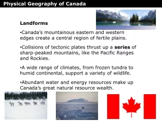
St. Lawrence Lowlands • Less than 2% of landmass; smallest region • Windsor to Quebec City • Sedimentary geology with glacial deposits • Moderate climate • Fertile soils • Long growing season • Close to the US • Canadian HEARTLAND
Canadian Shield • 50% of Canada’s landmass; largest region • Almost entirely contained in Canada • Geological core underlies North America • Precambrian rocks more than 3 billion yrs. • Exposed granite and shallow soils • Glaciation evident • Mixed Boreal forest • Northern continental climate
Appalachian Uplands • Over 2% of landmass • Northern part of Appalachians • Rounded uplands and plateaux • Numerous islands along drowned shoreline • Narrow river valleys • Rocky, shallow soils • Mixed forests • Cool maritime climate • Short summer wet, winter
Hudson Bay Lowlands • Over 3.5% landmass • Muskeg or wet peat lands • Many lakes • Low ridges of sand and gravel • Poorly drained • Level • Northern climate • Maritime influence • Short, warm summer • Long, cold winter
Interior Plains • About 20% land mass • Geologic base of sedimentary rock • Shaped by glaciation and re-directed drainage • Incised river valleys • Slopes up from east to west with rich soils • Hudson’s Bay watershed • Oil and gas deposits • Continental climate • Moderate to low precipitation
Cordillera • Region of intra-regional differences • About 16% of land mass • Formed 40-80 million years ago from collision of North American and Pacific Plates • Rockies up thrust sediments • Coastal mountains volcanic: ‘ring of fire’ • Glaciers remain in Alpine areas • Fertile valleys and deltas • Coniferous • Multiple micro-climates