Download
1 / 11
110 likes | 245 Views
GOES-R HES-CW Atmospheric Correction. Curtiss O. Davis Code 7203 Naval Research Laboratory Washington, DC 20375 curtiss.davis@nrl.navy.mil (202) 767-9296. HES-CW Products. The primary products are calibrated at sensor radiances for all channels

E N D
GOES-R HES-CW Atmospheric Correction Curtiss O. Davis Code 7203 Naval Research Laboratory Washington, DC 20375 curtiss.davis@nrl.navy.mil (202) 767-9296
HES-CW Products • The primary products are calibrated at sensor radiances for all channels • Either the threshold 14 channels and possibly the additional goal channels • The other required ocean product is chlorophyll by something like the MODIS standard algorithm • Products are geo-located to approximately 1 Ground Sample Distance (GSD) • Methods for on-orbit calibration and validation of products are not clearly defined at this time. • Methods for atmospheric correction are not clearly identified at this time.
Geostationary Field of Regard X X Figure 3.2.6 Approximate 62-degree LZA coverage regions as seen from east and west satellite positions. (HES PORD)
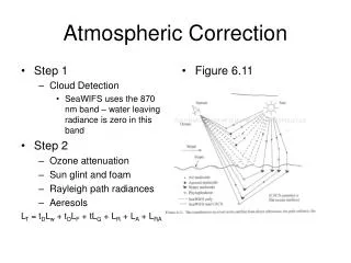
Atmospheric Correction Issues • Imaging a full range of sun and view angles at any one time. • Will encounter large areas of sunglint • Affects U. S. Coastal waters primarily in the summer • Could image the sunglint for water vapor and for internal waves • Current atmospheric models include solar zenith and view angles to +/-55 deg. • Can we extend to +/- 62 deg local zenith angle? • Can we extend to +/- 70 deg solar zenith angle? • Current atmospheric correction models could be used for demonstration and testing • Test range of sun and viewing angles with airborne hyperspectral data collections • Over many hours of the day • Over a range of view angles
Tafkaa Atmospheric Correction Including Surface Glint Correction for Ocean Scenes A B C D AVIRIS data were atmospherically corrected using the Tafkaa algorithm for ocean scenes. The data are corrected for skylight reflected off the sea surface and then it is assumed that the water leaving radiance is 0 for wavelengths greater than 1.0 micron. (Gao, et al., Appl. Opt. 39, 887-896, 2000)
PHILLS data for Great Bay Region (010731 Run15seq03) • The image is 1000 pixels wide and 1024 pixels long. The spatial resolution is 1.8 meters. • The data was processed to Rrs using laboratory calibration data, and the Tafkaa atmospheric correction. • “X” marks the location of spectra shown below. (C. O. Davis, et al., (2002), Optics Express 10:4, 210--221.) X
Bo-Cai Gao MODIS Team Activities • MODIS has five channels located near 1 mm for remote sensing of water vapor. MODIS also has a narrow channel centered at 1.375 mm for remote sensing of high clouds. • Responsible for the MODIS near-IR water vapor algorithm and the cirrus reflectance algorithm using those channels. • 14 reviewed publications on these topics. Highlight recent results and show the need for cirrus cloud corrections for aerosol and sea surface temperature retrievals.
Water Vapor Image (MODIS + SSMI) MODIS Vapor (7/2002) Vapor (MODIS + SSMI) SSMI Vapor (7/2002) (Gao, B.-C., P. K. Chan, and R.-R. Li, A global water vapor data set obtained by merging the SSMI and MODIS data, Geophys. Res. Lett., 31, 2004 (doi:10.1029/2004GL020656).)
SST (MODIS, 01/2003) SST DIFF (MODIS – TMI) SST (TMI, 01/2003) Cirrus Reflectance (01/2003) Chan, P. K., and B.-C. Gao, A comparison of MODIS, NCEP, and TMI sea surface temperature data sets (in press).