Download
1 / 19
190 likes | 314 Views
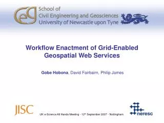
Semantically-Assisted Geospatial Workflow Design. Gobe Hobona , David Fairbairn, Philip James g.e.hobona@newcastle.ac.uk. ACM GIS – 8 th November 2007 - Seattle. Overview. Background OGC Web Services Workflow Enactment A Role for Semantics Prototype Implementation Conclusions.

E N D
Semantically-Assisted Geospatial Workflow Design Gobe Hobona, David Fairbairn, Philip James g.e.hobona@newcastle.ac.uk ACM GIS – 8th November 2007 - Seattle
Overview • Background • OGC Web Services • Workflow Enactment • A Role for Semantics • Prototype Implementation • Conclusions
Background • Open Geospatial Consortium (OGC) • JISC Grid/OGC Collision Programme • Security : SEE-GEO • Workflow : SAW-GEO • OGC Interoperability Experiments (OWS-4 and beyond) • Challenge: How to support the user in the construction of workflows to address a variety of problems?
OGC Web Services • Web Map Services (WMS) • Generates geovisualisations/maps from any geo-data source • Web Feature Services (WFS) • Disseminates vector geospatial data • Web Coverage Services (WCS) • Disseminates raster geospatial data • Web Processing Services (WPS) • Runs geocomputational models or geospatial operations on user-supplied datasets
Workflow Enactment • Recognised by ISO19119 • Several options for workflow enactment • SCUFL, BPEL, Keppler etc • Selected BPEL because • OASIS Standard, i.e. WS-BPEL 2.0 • Multi-vendor support including IBM, Sun Microsystems, ActiveEndpoints, Oracle etc • Availability of open source enactors
An Example Geospatial Workflow WPS 1 Generalise WFS Workflow Enactor client WPS 2 Clip Based on OGC OWS-4 GeoProcessing Workflow Scenario
Possible Applications for Geo-Workflows • Emergency Management • Where each activity depends on the result of a previous activity • Geographic modelling • Where several steps are needed before a final model is produced e.g. ESRI Model Builder • Climate Change scenarios • Where a number of possible routes for workflows are possible depending on the state of certain variables
Concept 1 Concept 2 Concept 3 Concept 4 SUBSUMPTION EXACT Concept 3 Concept 1 Concept 5 A Role for Semantics in Orchestration Problem Domain SOA Services Resources Workflow enactor
Thing B D C E A J L K M I Calculating Workflow Similarity (1) Key: X A concept A path linking two concepts. The concept on the ‘arrow-head’ subsumes the other A path through several other concepts
Proposed Formula • α is an application-specific weight applied to each activity in the workflow • n is the number of activities in the requested workflow • Pk is the number of edges between the concept representing the kth activity in the workflow and the concept tagging a candidate service
A Geospatially aware Ontology • Earth and environmental problem domains present problems of space • Requiring a geo-aware ontology • SWEET* • Earth Realm • Physical Process • Physical Property • Non-Living Substances • Living • Data • Human Activity • Numerics • Natural Phenomena • Space • Time • Units * Raskin, R. G. and Pan, M. J. Knowledge representation in the semantic web for Earth and environmental terminology (SWEET).Computer & Geosciences, 31, 9 (2005), 1119-1125.
Implementation • SWEET ontology uploaded from OWL documents into PostgreSQL • Metadata held in a conventional DBMS with a catalogue service interface • For each query, semantically related concepts found using Jena • Additional methods implemented to calculate the number of edges
Architecture Eclipse IDE BPEL Editor SAW-GEO Plug-In Client-side Server-side Catalogue Service Jena Metadata Ontology
Search Concept Number of edges between Search Concept and tag Response from Search <Result class="http://sweet.jpl.nasa.gov/ontology/space.owl#AdministrativeRegion"> <Resource id="tiger:poly_landmarks@http://geoserver.itc.nl:8080/geoserver" edges="0" type="wfs" owl="http://sweet.jpl.nasa.gov/ontology/space.owl#AdministrativeRegion"/> <Resource id="topp:tasmania_state_boundaries@http://gist.fsv.cvut.cz:8080/geoserver" edges="1" type="wfs" owl="http://sweet.jpl.nasa.gov/ontology/space.owl#Region"/> <Resource id="tiger:giant_polygon@http://geobrain.laits.gmu.edu:8099/geoserver" edges="2" type="wfs" owl="http://sweet.jpl.nasa.gov/ontology/space.owl#SpatialObject"/> </Result>
Ontology and Suggested Flow views ‘plugged into’ ActiveBPEL Designer
Evaluation • 15 OGC web services with 180 resources compiled from a Google search for GetCapabilities documents • Resources tagged with references to OWL Concepts • Tags assigned according to specialist words in resource titles • Resource titles obtained from GetCapabilities methods • Average response time for discovery and edge count • Greatest cost where several resources are tagged with concepts ‘far away’ from the search concept • Possibilities for parallelisation as each concept can be searched for on a separate machine
Conclusions and Future Work • Proposed formula offers an algorithmic approach for comparing linear workflows • Limitations to complete automation due to variations between properties of service inputs and outputs • Future work should investigate non-linear workflows and the inclusion of conditional activities • Need for a test corpus for evaluating catalogues of OGC web services Thank You g.e.hobona@newcastle.ac.uk


![[1] semantically annotated accommodations](https://cdn1.slideserve.com/2531262/slide1-dt.jpg)