Download
1 / 72
740 likes | 991 Views
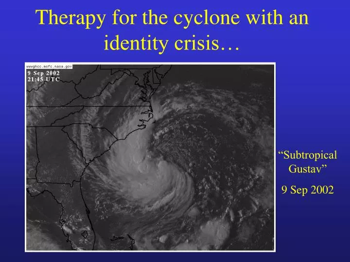
Therapy for the cyclone with an identity crisis…. “Subtropical Gustav” 9 Sep 2002. Images courtesy NCDC. Quiz: Separate the 5 tropical cyclones from the 5 extratropical. Some relevant questions…. What makes a cyclone warm or cold-core?

E N D
Therapy for the cyclone with an identity crisis… “Subtropical Gustav” 9 Sep 2002
Images courtesy NCDC Quiz: Separate the 5 tropical cyclones from the 5 extratropical.
Some relevant questions… • What makes a cyclone warm or cold-core? • If all low pressure areas result from a column of air that is on average warmer than its environment, how can there be cold-core cyclones? • What are the hydrostatic consequences of this thermodynamic structure & the resulting profile of cyclone “strength”? • What about existence of mixed phase cyclones? • Why the fuss? 60 knots is 60 knots!
Hurricane Bonnie (1998) Temperature Anomaly Classic warm-core cyclone: TC 12km 6km 1km - Low pressure results from column of air on average warmer than environment, with the anomalous warmth in the troposphere Source: Advanced Microwave Sounder (AMSU) Temperature Anomaly + Image courtesy Mark DeMaria, CIRA/CSU www.cira.colostate.edu/ramm/tropic/amsustrm.asp
Classic warm-core cyclone: TC TC Height Field (m) from hydrostatic balance Warm: expansion of surfaces Cold: contraction of height surface
Classic warm-core cyclone: TC Height anomaly from zonal mean shaded Height perturbation increases with altitude in troposphere
- + Cold Stratosphere Z Troposphere Wa rm L Height perturbation Classic warm-core cyclone: TC • Intensifies through: sustained convection, surface fluxes. • Cyclone strength greatest near the top of the PBL Gradient wind balance in a convective environ.
Classic cold-core cyclone: Extratropical Cleveland Superbomb Temperature Anomaly Low pressure results from column of air on average warmer than environment, with the anomalous warmth in the stratosphere L 2.5 NCAR/NCEP reanalysis
Classic cold-core cyclone: Extratropical Height anomaly from zonal mean shaded Height perturbation decreases with altitude in troposphere
- + Height perturbation Classic cold-core cyclone: Extratropical • Intensifies through: baroclinic development, tropopause lowering. • Cyclone strength greatest near tropopause QG balance in a minimally convective environ Cold Warm Stratosphere Z Troposphere Cold Warm L
- + Warmer Stratosphere Z Troposphere Colder Warmer L Height perturbation Hybrid (non-conventional) cyclone What if an occluded extratropical cyclone moves over warm water? Characteristics of tropical and extratropical cyclones.
Tannehill (1938): 1938 New England Hurricane Pierce (1939): 1938 New England Hurricane Knox (1955): Hurricane Hazel Palmén (1958): Hurricane Hazel Simpson (1972): “Neutercanes” Hebert & Poteat (1975): Subtropical cyclones Kornegay & Vincent (1976): T.C. Candy Bosart (1981): President’s Day Snowstorm DiMego & Bosart (1982): Hurricane Agnes Gyakum (1983): QE2 Storm Shapiro & Keyser (1990): Warm seclusion extratropical Bosart & Lackmann (1995): Hurricane David Beven (1997): Cyclone diagram,Hybrid cyclones, Mediterranean Miner et al. (2000): Hurricane “Huron” Thorncroft & Jones (2000): Hurricanes Iris & Felix Examples of nonconventional cyclones: Past research
? 940hPa Non-conventional cyclones: Examples 1938 New England Hurricane • Began as intense tropical cyclone • Rapid transformation into an intense hybrid cyclone over New England (left) • Enormous damage ($3.5 billion adjusted to 1990). 10% of trees downed in New England. 600+ lives lost. • Basic theories do not explain a frontal hurricane Pierce 1939
Non-conventional cyclones: Examples Christmas 1994 Hybrid New England Storm • Gulf of Mexico extratropical cyclone that acquired partial tropical characteristics • A partial eye was observed when the cyclone was just east of Long Island • Wind gusts of 50-100mph observed across southern New England • Largest U.S. power outage (350,000) since Andrew in 1992 • Forecast 6hr earlier: chance of light rain, winds of 5-15mph. NCDC
Model interpretation: What type of development? PMIN=1009hPa PMIN=1001hPa PMIN=1005hPa PMIN=1003hPa
Why is the phase of a cyclone important? • Predictability is a function of cyclone phase • Model interpretation/trust is a function of phase • It is often not at first apparent what the model is forecasting, or the nature of cyclone development • MPI is a function of cyclone phase
Impact is a function of structural evolution and interaction Floyd (1999): Transition from pos. tilt trough Hazel (1954): Transition from a neg. tilt trough Fran (1996):No transition Analysis courtesy NCAR/NCEP Reanalysis-2 Analysis courtesy Jim Abraham, CHC Analysis courtesy NOAA/NWS/NHC
Significance: • Classification • Better understanding of the current state • Applying conceptual models • The type/extent of expected impact/damage • Quantifying potential for intensity change and its uncertainty • Scales of motion dependence • Maximum intensity • How can intensity change be forecast if there is great structural uncertainty? • Amount of intrinsic (mis)trust of numerical model forecasts Need a diagnosis of basic cyclone structure that is more flexible than only tropical or extratropical
Goal:A more flexible approach to cyclone characterization • To describe the basic structure of tropical, extratropical, and hybrid cyclones simultaneously using a cyclone phase space. Parameter B Phase Space Parameter C Parameter A
- - - + + + Height perturbation Height perturbation Height perturbation Cyclone Parameter 1: Vertical structure -VT: Thermal Wind [Warm vs. Cold Core] Warm core Hybrid Cold Core 300mb 600mb 900mb
Two layers of interest Cyclone Parameter -VT: Thermal Wind Warm-core example: Hurricane Floyd 14 Sep 1999 Vertical profile of ZMAX-ZMIN is proportional to thermal wind (VT). Z Z Z Z Z Z Z Z Z
Cyclone Parameter -VT: Thermal Wind Cold-core example: Cleveland Superbomb 26 Jan 1978
Cyclone Parameter 2: Horizontal structureB: Thermal Asymmetry Symmetric Hybrid Asymmetric
Cyclone Parameter B: Thermal Asymmetry • Defined using storm-relative 900-600hPa mean thickness field (shaded) asymmetry within 500km radius: B >> 0: Frontal B0: Nonfrontal 3160m 3260m L Cold Warm
Conventional Tropical cyclone: B 0 Forming Mature Decay L L L • Conventional Extratropical cyclone: B varies Developing Mature Occlusion L L L B >> 0 B > 0 B 0 Cyclone Parameter B: Thermal Asymmetry
Constructing 3-D phase space from cyclone parameters: B, -VTL, -VTU A trajectory within 3-D generally too complex to visualize in an operational setting Take two cross sections (slices) : B -VTU -VTL -VTL
Hurricane Mitch (1998)Case of symmetric, warm-core development and decay Classic tropical cyclone
Symmetric warm-core evolution: Hurricane Mitch (1998)Slice 1: B Vs. -VTL
Symmetric warm-core evolution: Hurricane Mitch (1998)Slice 1: B Vs. -VTL
Symmetric warm-core evolution: Hurricane Mitch (1998)Slice 2: -VTL Vs. -VTU Upward warm core development maturity, and decay. With landfall, warm-core weakens more rapidly in lower troposphere than upper.
Symmetric warm-core evolution: Hurricane Mitch (1998)Slice 2: -VTL Vs. -VTU Upward warm core development maturity, and decay. With landfall, warm-core weakens more rapidly in lower troposphere than upper.
December 1987 Extratropical CycloneCase of asymmetric, cold-core development and decayClassic occlusion of an extratropical cyclone
Asymmetric cold-core evolution: Extratropical CycloneSlice 1: B Vs. -VTL
Asymmetric cold-core evolution: Extratropical CycloneSlice 1: B Vs. -VTL
Asymmetric cold-core evolution: Extratropical Cyclone Slice 2: -VTL Vs. –VTU
Asymmetric cold-core evolution: Extratropical Cyclone Slice 2: -VTL Vs. –VTU
Hurricane Floyd (1999)Multiple phase evolution:Case of extratropical transition of a tropical cyclone
5 4 Warm-to-cold core transition: Extratropical Transition of Hurricane Floyd (1999): B Vs. -VTL 3 5 B 2 4 3 1 1 2 -VTL
Extratropical transition ends when –VTL < 0 B Extratropical transition begins when B=10m -VTL Warm-to-cold core transition: Extratropical Transition of Hurricane Floyd (1999) B Vs. -VTL Provides for objective indicators of extratropical transition lifecycle.
Spaghetti Plot of 34 Cyclone Phase Trajectories based upon Navy NOGAPS operational analyses 960hPa 970hPa 980hPa 990hPa 1000hPa 1010hPa Asymmetric Cold-Core Asymmetric Warm-core B Symmetric Cold-core Symmetric Warm Core -VTL
Composite Mean ET Structural Evolution Summary 34-Cyclone Composite Mean Phase NOGAPS-analysis based Trajectory with key milestones labeled TE+24h TE TE+48h TMID TB TE+72h TB-24h TB-72h TB-48h
Variability About the Composite Mean Boxes represent the calculated one standard deviation spread about the 34-cyclone consensus mean trajectory for each time Considerable variability about mean once transition completed=> posttropical phase can take many forms….
Floyd (1999): Non-intensifying cold-core development (40%) Hugo (1989): Explosive cold-core development (20%) Dennis (1999): “ET-Interruptus”. ( 5%) Charley (1986): Schizophrenia (20%) Keith (1988): Explosive warm-seclusion development (15%)
Hurricane Olga (2001)Multiple phase evolution:Case of tropical transition of a cold-core cyclone
-VTU Tropical transition completes when –VTU > 0 (tropical status) Tropical transition begins when –VTL > 0 (subtropical status) -VTL Cold-to-warm core transition: Tropical Transition of Hurricane Olga (2001) -VTU Vs. -VTL
Summary of cyclone types within the phase space ?Polar lows?
Phase space limitations • Cyclone phase diagrams are dependent on the quality of the analyses upon which they are based. • Three dimensions (B, -VTL, -VTU) are not expected to explain all aspects of cyclone development • Other potential dimensions: static stability, long-wave pattern, jet streak configuration, binary cyclone interaction, tropopause height/folds, surface moisture availability, surface roughness... • However, the chosen three parameters represent a large percentage of the variance & explain the crucial structural changes.