Download
1 / 18
230 likes | 1.28k Views
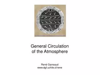
The General Circulation of the Atmosphere. Weather with different scales. What we need to know for today. Pressure gradient force: from H igh to L ow pressure Coriolis force (effect): Results from the rotation of the planet. Maximum at the poles and no effect at the equator.

E N D
What we need to know for today • Pressure gradient force: from High to Low pressure • Coriolis force (effect): • Results from the rotation of the planet. • Maximum at the poles and no effect at the equator. • Acts perpendicular to the direction of motion: changes the direction of the wind but not the wind magnitude. • In the NH deflects the wind to the right. • In the SH deflects the wind to the left. • Winds aloft • Balance between the pressure force and the Coriolis force. • The wind is parallel to the isobars. • Surface winds • Balance between the pressure gradient force, the Coriolis force and the air friction. • The wind crosses the isobars (from High to Low pressure).
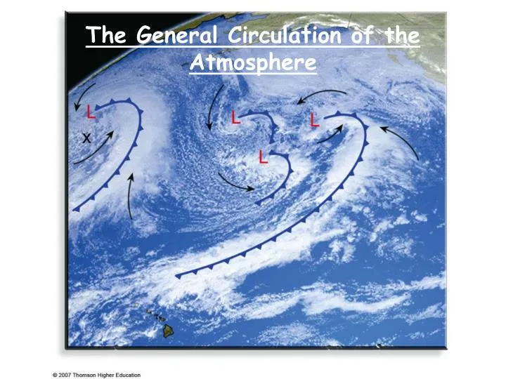
Average Wind Structure • The direction and the magnitude of the winds at a given location can vary significantly during the day, and from day to day. • The general circulation (GC) refers to the average (the prevailing) winds on a global scale (around the world). • The GC of the atmosphere is the result of the uneven heating of the Earth’s surface. • It is impacted by the Earths rotation. • The GC transports and redistributes energy from one region to another (warm air towards the poles and cold air towards the equator).
The Single Cell Model • This is a very simplified model based on the following three assumptions: • The Earth’s surface is uniformly covered with water (no differential heating of the land and the oceans) • The sun is always directly over the equator (no seasonal variations of the winds). • The Earth does not rotate. • No Coriolis effect. • The only active force is the pressure gradient force.
Thermal circulations • Due to uneven heating of the surface. Example: • South area heats up, North area cools • Warmer southern air aloft moves north towards low pressure • It then cools and sinks • Surface pressure to the North increases • Surface wind from N to S • The surface air warms up and rises. • The process continues
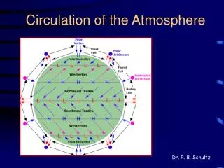
The Hadley Cell • It is driven by the uneven heating of the Earth’s surface by the sun - thermally direct cell: warm air rises, cold air sinks. • One Hadley cell in each hemisphere. • The equator is warmer than the poles. • Warm moist air at the equator rises upwards • It expands, cools, and saturates, the water vapor condenses and forms clouds. • It creates low surface pressure in the tropics. • At the poles we have cool, dry, sinking air that creates high surface pressure in the polar region. • The PGF (pressure gradient force) drives the surface winds from the poles towards the equator. • The winds aloft close the cell by blowing from the equator towards the poles.
The one cell model does not work! • It is obviously wrong: predicts northern prevailing winds everywhere in the NH • What is wrong with the model? It is too simple! • The rotation of the Earth will deflect the winds to the right in the Northern hemisphere and to the left in the Southern hemisphere. • This will result in surface winds blowing: • From the East (easterlies) in the NH • From the East (easterlies) in the SH • This will result in winds aloft blowing: • From the West (westerlies) in the NH • From the West (westerlies) in the SH
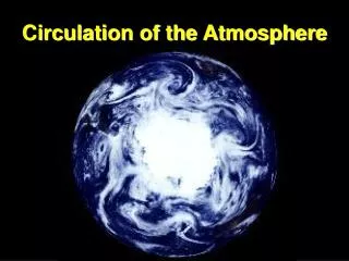
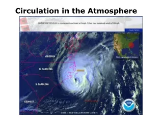
Intertropical convergence zone Observing global winds from space
Winds Aloft • Warm air above the equator and cold air above the polar regions • Higher pressure at the equator, lower pressure both to the north and to the south of the equator • The pressure gradient force is towards the poles, sets the air in motion • The Coriolis force • NH: to the right • SH: to the left • The wind turns right in the NH and left in the SH, becomes parallel to the isobars • Westerly winds aloft in both the NH and SH. • Easterly winds at the surface in both the NH and SH.
The Three Cell Model • Keep two of the assumptions, relax the third: • The Earth is covered with a continuous ocean • The sun is always directly over the equator • The Earth rotates -> Coriolis force!
Three cell model: the Hadley cell (0-30 deg) • Thermally direct cell: warm air rises, cool air sinks • Intertropical Convergence Zone (ITCZ) • A.k.a. equatorial doldrums • Warm air, weak PGF, light winds, cumulus clouds and thunderstorms • Air rises up to the tropopause, then laterally toward the poles • Deflected east due to the CF • Winds aloft in NH: from southwest • Subtropical highs (anticyclones) • Equatorial air cools, sinks, warms up, clear skies -> major deserts • Air converges (follow the meridians on a globe) – high surface pressure • Horse latitudes: small PG, weak horizontal winds -> sailors get stuck • Surface winds in NH: from the northeast (Trade winds)
Three cell model: the Ferrel cell (30-60 deg) • Thermally indirect cell: cool air rises and warm air sinks • Some of the sinking air in the horse latitudes heads toward the pole • Deflected east by the CF • Surface winds in NH: from the southwest (westerlies) • At the polar front the westerlies encounter cold air moving down from the poles • Air is forced to rise, some of it returns to the horse latitudes, completing the Ferrel cell, the rest heads for the pole • Upper air winds in the Ferrel cell: from the northeast. William Ferrel William Ferrell
Three cell model: the polar cell (60-90 deg) • It is a Hadley type of circulation. • Surface winds: from the north east (polar easterlies) • Upper winds in NH: from the southwest • Summary: two major areas of Low pressure (ITCZ and subpolar low), and two of High pressure (poles and subtropical highs)
The converging/diverging regions • ITCZ (Intertropical Convergence Zone ) - Equator • Low surface pressure with small PG and weak horizontal winds. • Upward motion of warm moist air. Results in convective cloud towers • Subtropical highs (the horse latitudes) – 30N; 30S • High surface pressure • The upper air is sinking, warms up and the relative humidity is very low. • Weak winds, clear sky, dry climate – large deserts at these latitudes. • Subpolar lows (polar front) – 60N, 60S • A converging zone at the surface. Air moves up and results in strong storms. • Weak winds • Polar highs – 90N, 90S
Winds and pressure in the real world • Semi-permanent highs and lows: persist throughout the year, correspond to converging/diverging upper air masses. • Bermuda, Pacific highs; Icelandic, Aleutian lows • Seasonal highs and lows (continents heat/cool faster) • Winter: Siberian high, Canadian high • Summer (thermal lows): Southwest US, Iran January July Subtropical highs Subtropical highs
The General Circulation and Precipitation Paterns • Converging surface flows: • Low surface pressure • Uprising air • Heavy precipitation • Diverging surface flows: • High surface pressure • Sinking air • Dry climate
Winds and Pressure Systems Aloft • The wind system aloft differs from the surface wind system. It is close to a geostrophic flow. • There is no significant friction with the ground. • The three cell model does not work that well in the middle latitudes. • The winds aloft are stronger than on the ground. • In the winter the gradients are bigger -> the winds are stronger. July January