Download
1 / 26
260 likes | 611 Views
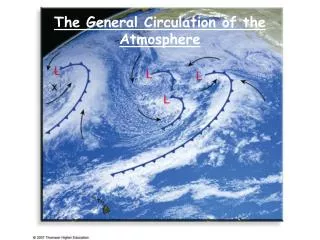
The General Circulation of the Atmosphere. Large scale flow of the atmosphere Focus on both upper level and lower level winds Definitions: Zonal winds: Meridional winds: Westerly winds; come from the west Southwest winds, come from the southwest. General Circulation of the Atmosphere.

E N D
Large scale flow of the atmosphere Focus on both upper level and lower level winds Definitions: Zonal winds: Meridional winds: Westerly winds; come from the west Southwest winds, come from the southwest General Circulation of the Atmosphere East-West North-south
Scale Time Scale Distance Scale Examples Macroscale -Planetary Weeks to years Westerlies, trade winds -Synoptic Days to weeks Cyclones, anticyclones and hurricanes Mesoscale Minutes to days Land-sea breeze, thunderstorms and tornadoes Microscale Seconds to minutes Turbulence, dust devils and gusts Atmospheric Scales of Motion 500 – 25,000 miles 50 – 3,000 miles 1 – 50 miles < 1 mile
Conservation of Angular Momentum • Describes motion of air/earth on a rotating planet • Says if all winds blew from one direction (east/west), planet’s rotation rate would have to change • If the atmosphere speeds up (stronger westerly winds) then the solid Earth must slow down (length-of-day increases). • So, winds are westerly some places, easterly at others.
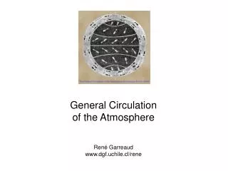
Early description of general circulation George Hadley (1685-1768) developed this model Assumptions: Earth is primarily heated in the tropics Thermally direct circulation results from heating differences Low pressure at equator, high-pressure at the poles Surface heat imbalance produces air movement to balance. Single Cell Model Not realistic, because it violates COAM
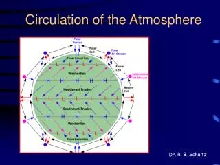
Proposed to explain how the Earth’s heat balance is maintained Good simple model of global circulation Terms: Hadley Cell: The tropical circulation ITCZ - intertropical convergence zone Horse Latitudes: Three Cell Model
Global wind patterns • Must conserve angular momentum, so direction varies • Westerlies: what we experience here in U.S. • Weather in east coast usually starts here. • Trade Winds: from NE in NH, SE in SH • E.g. Hawaii • El Nino: when trade winds reverse directions, which cools W. Pacific and warms E. Pacific oceans • Doldrums • Area of no wind (ITCZ) where only air movement in up!
Semi-permanent pressure systems • Part of 3-cell model • Exist due to seasonal changes and land-sea differences (specific heat) • Change with the seasons. • Land: • predominantly high pressure in winter • predominantly low pressure in summer • Water: • predominantly low pressure in winter • predominantly high pressure in summer • Think of cold areas as having the high pressure. Warm areas/low pressure
ITCZ Seasonal variations • Intertropical Convergence Zone (ITCZ) • Is a semi-permanent low-pressure system where the trade winds meet and converge, forcing rising motion • ITCZ changes with season • This is a reflection of the changing location of the Hadley Cell • The ITCZ follows the sun • To the north in June • To the south in December
Positions of intertropical convergence zone in January and July
Positions of intertropical convergence zone in January and July
Westerly winds in the upper atmosphere • The Jet Stream • Caused by differences in temperatures at the surface, or uneven heating of the surface • Higher heights (of pressure levels) exist in the tropics. • Pressure gradient exists across middle latitudes • Pressure gradient force is stronger in winter than summer • larger temperature gradient. • Upper atmosphere winds are predominately • westerly in both hemispheres.
The Jet Stream • Due to large differences in temperature at the surface • Strongest in winter • Flow from west to east in a wavy pattern • ~35,000 feet above sea level • Illustrates that atmosphere is full of waves that • Bring heat from equator to poles • Bring cold air from poles to equator • Control our weather here in the mid-latitudes • Fronts, low-pressure troughs, and high-pressure ridges
• A • B • C