Download
1 / 50
600 likes | 894 Views
Groundwater. General Geology Prof. Boris Natalin. Early studies. Caves and underground streams have been observed by many people. People infer that he interior of the Earth looks like a sponge.

E N D
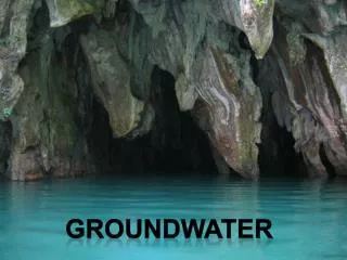
Groundwater General Geology Prof. Boris Natalin
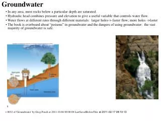
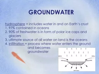
Early studies • Caves and underground streams have been observed by many people. • People infer that he interior of the Earth looks like a sponge. • Empedocles (~546 B.C.), Plato (428-348 B.C.), René Descartes (1596-1650). adopted this theory • This ‘sponge theory remained popular until the 17th century Channels in the Earth
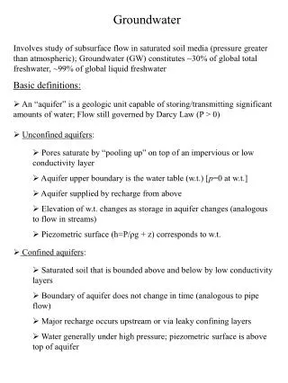
Underground streams do exist but main volume of groundwater occupies fractures and pores between mineral grains.
Soil moisture Intermediate belt Zone of aeration Water table Ground water Zone of saturation
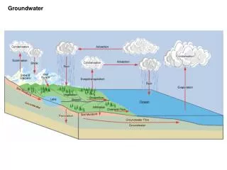
How water table looks in cross section of land Surface water Water table Ground water Water table is replica of the Earth surface
Water table map - Arrows shows ground water flows - In the Konya Basin, Central Anatolia, human activity exceeds the sustainable level of water table. Since 1968, it dropped almost 24 m.
Water table and streams Gaining streams Loosing stream Types of stream vary along the same river
Porosity and permeability • Porosity • Permeability Specific yield Specific retention
- Layer’s heterogeneity - Aquitards -Aquifers - Movement of water is slow (a few cm/day Movement is a compromise between downward pull of gravity and tendency of water to move in areas of lower pressure. Curved passes
Darcy Law • Hydraulic gradient (h1-h2)/d • Q = KA (h1-h2))/d Discharge, Q,
Springs • Hot springs and geyser • Pamukkale
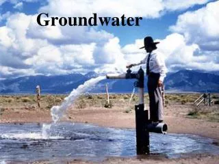
Groundwater and irrigation • Wells and water table • Well usage lead
Artesian wells The term artesian refers to any situation in which groundwater under pressure rises above the level of aquifer. - Pressure surface - Nonflowing and flowing artesian wells Confined aquifer
Groundwater withdrawal problems • Balance of nature systems • Drops of water table • Land subsidence • Saltwater contamination
Groundwater contamination • Sewage system and filtration • Lithology of aquifer
Caverns and sinkholes (obruk) Solubility of limestones - Caverns (caves) and water table. - Lines of weakness. - Cavers levels. - Speleothems: Stalactite and Stalagmites
Karst topography Sinking stream Sinkholes Water table Water table
Glaciers and Glaciation • A glacier is a thick ice mass that originate on land during hundreds or thousands years. • Mechanism of origin. • Motion of glaciers. Types of glaciers • Valley glaciers or alpine glaciers • Ice sheets • Ice caps (small, Iceland, islands in the Arctic Ocean
Ice sheets Ice shelves
Formation of Glacial Ice • Evaporation and condensation. • Firn. • Transformation into the ice.
Movement of glaciers (flow) • Brittle solid motion • Plastic flow • - Basal slip. • - Friction drag.
Crevasses Rate of movement 750-800 m per year in large glaciers. 200 m per year in small Surging glaciers move at 12 km per year
- Snowfalls and snow melting; • Snow line and zone of accumulation; • - Zone of wastage; • Calving; • Budget of a glacier • Ablation Zone of ablation
Glacial erosion Plucking Abrasion Glacial striation
Landform created by alpine glaciers • Topography is sharp, angular • Ice sheet • - Smooth topography Morphology of alpine glaciers
U-shape glacial trough pater noster lakes Valley is straightened!
Waterfall from a hanging valley Glacier eroded the valley and than receded!
Arêtes and horns Arêtes
RochesMountonnées • - Asymmetric shape; • Origin • Tape of glacier
Glacial deposits - Glacial drift (Noachian flood). - Mechanical weathering Glacial drift has two basic types: - Till • Stratified drift Both types form specific landforms
- Unsorted material, deposited after ice melting - Rock pieces are polished and scratched Till
Glacial deposits: lateral moraines Alpine glacier moraine moraine
Glacial deposits: end and ground moraines - Terminus of glacier mark balance between ablation and ice accumulation Glacier receding forms ground moraine
Landforms made of stratified drift Traces of ice plastic flow Ground moraine
Crustal subsidence and rebound (isostatic adjustment) - Rise of Scandinavia and Canada (300 m)
Ice sheets Ice shelves
The glacial theory and the Ice Age • IgnazVenetz (1821) noted that glacial landscape is far from modern glaciers • Louis Agassiz (1836) apply Hutton’s uniformitarianism for explanation. • 30% of Earth land area was affected by ice • The Ice Age (the Pleistocene) started 2.5 million yeas ago
Pleistocene Ice Age Four major glacial periods( "glacial" ) younger older Three major interglacial periods Last glacial epoch began about 110,000 and ended about 10,000 years ago. Maximum extent of glaciation was approximately 22,000 years ago.
Effects of Ice-Age glaciers • Migration and extinctions of animals and plants • Courses of rivers • Sea level falls and rises (during the Ice Age the sea level was lower 100 m) • Rise of Scandinavia and Canada (300 m)
Causes of Glaciation • What causes the onset of glacial conditions?- Long-term changes of temperature conditions- millions years • What causes the alternation of glacial and interglacial stages that have been documented for the Pleistocene epoch?- short-term changes of temperature conditions- thousands years
Glaciation and plate tectonics Tillite is a sedimentary rock formed by lithified glacial till Pangea and the Permian (250 Ma) glaciation
Causes of glaciation: Variations in Earth’s orbit Milankovitch cycles explain variation of solar energy reaching Earth’s surface A – variation in orbit shape (100,000 years) B – changes in obliquity (axial tilt) - (41,000 years) C – the wobbling of Earth axis (23,000 years)