Download
1 / 19
190 likes | 202 Views
DNDC-Europe is a comprehensive tool for simulating agricultural systems. It integrates socio-economic and environmental databases, climate data, and more to model land use and environmental impacts accurately. The model calculates nitrogen, carbon, and water balances, simulating environmental indicators like N2O and CH4 emissions. Short-term improvements include realistic weather data and enhanced fertilizer distribution. The model's spatial resolution ranges from 1km to continental scale. Future enhancements involve refining the HSMU layer for improved mapping accuracy.

E N D
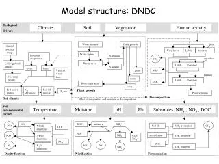
DNDC-EUROPE Adrian Leip, Joint Research Centre • DNDC-EUROPE: quick description of concept and status • Improvement of HSMU-layer for improved land use map and simulation units • Preparing cross-compliance simulations
DNDC-EUROPE Socio-economic database GIS environmental database European national and international statistics Geographic data Climate data and N deposition CAPRI DNDC Policy framework National market/trade Definition of environmental scenario Soil information Global trade framework Farm Management Regional agricultural system + economic and environmental indicators Aggregation to modeling spatial units Regional statistics Agricultural land use map Production level and farm input estimation at spatial calculation units Simulation at modeling spatial unit • Environmental indicators • - N2O, N2 • NOx • CH4 • NH3 • Nitrate leaching • Carbon Stocks • Livestock density • … Developed in CAPRI-DynaSpat
DNDC-EUROPE 1. Geographic information 2. Link to climate file GIS database for individual simulation units 3. Soil data Climate library (including deposition) 4. Cropping information# 5. Farm management data$ Output(one file per simulation year) 6. Crop physiological data$ 7. Initialization for winter crops$
…. Soil Map again Relative decrease of organic carbon stocks Relative decrease of N2O fluxes
The model calculates full balance of nitrogen, carbon and water • Spatial resolution: from 1 km-pixel to continental • matching of environmen-tal conditions with anthropogenic activities • Temporal resolution of the model is <= 1 h for some processes
Short-term improvements • Realistic weather from 1975 – 2005 • Slightly improved fertilizer and manure distribution • Estimation of potential yield • Higher number of HSMU • DNDC on windows and unix computers • Distributed simulation
Improved version of the HSMU layer • HMU • (Homogeneous Mapping Units): • Individual ID for the intersection of • Slope • Administrative borders • Soil mapping units • Soil typological units • HSMU: • (Homogeneous Soil Modelling Units) • Dissolve SMU layer • HSMU-II will not be georeferenced • … but ‘pure’ from viewpoint of environmental characteristics • NCU: • Aggregation of the STU • Result will be an update of the old HSMU layer with Corine resolved (as discussed in Paestum) NITRO-EUROPE CCAT
2. Corine will NOT be used any more to delineate the HSMU • Reduction of the number of the HSMU (relevant for the generation of the agri-land use map) • Corine 100 m will be used to calculate “land cover shares” in HSMUs
3. Working at the STU-level • without Corine and with STU there are 104000 HSMU for EU25 • transparent application of pedo-transfer rules ….
Simulating cross-compliance • Set up default run on the basis of CC measures and compliance assumptions • Review of the parameterization of important management activities • Tillage • Irrigation • Fertilizer application • Two Tier-approach • Simple implementation fo CC measures to screen a wide range of measures • More detailed evaluation of most sensitive measures
Simulating cross-compliance (cont’d) • More attention to crop-specific data (genetic variability, regional differences) • Continue to work on nitrogen application rates • Focus of simulations: • NEU: EU-GHG balance of arable soils • CCAT: specific crops/scenarios