Download
1 / 4
40 likes | 56 Views
Explore the intricate connection between weather and climate in hydrology, including tools, models, and concepts used for forecasting floods, managing water resources, and addressing climate change scenarios. Learn about the importance of feedback mechanisms, uncertainty analysis, and converting hydrologic predictions to water elevation.

E N D
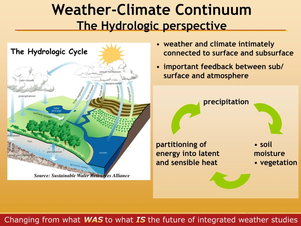
Weather-Climate Continuum The Hydrologic perspective The Hydrologic Cycle Source: Sustainable Water Resources Alliance • weatherand climate intimately connected to surface and subsurface • important feedback between sub/ surface and atmosphere precipitation partitioning of energy into latent and sensible heat • soilmoisture • vegetation
Weather-Climate Continuum Methods, tools and concepts • Weather (short-term) • USES: • flash flood forecasting • hydroelectric generation • METHODS and TOOLS • Numerical Models • uncoupled (no feedback) • Climate (seasonal, annual, decadal…) • USES: • flood forecasting • water supply • ecologic purposes • hydroelectric generation • navigation • flood plain management • climate change scenarios • METHODS and TOOLS • Numerical Models • coupled to General Circulation Models of the atmosphere
Weather-Climate Continuum Methods, tools and concepts • Weather (short-term) • Uncertainty Analysis • Inputs: • Precipitation, wind, pressure, temperature, etc • Outputs: • Forecaster SKILLS • volume, time to peak, magnitude of peak • probability measure • Initial conditions and soil moisture • Model • Climate (seasonal, annual, decadal…) • Uncertainty Analysis • Inputs: available at larger spatial scales than needed for hydrologic predictions (General Circulation Models) • Precipitation wind, pressure, temperature, vegetation, etc • Outputs: • Automatic algorithms for calibration • volume, time to peak, magnitude of peak • probability measure • Initial conditions and soil moisture • Model
Summary: no big differences in tools and methods between weather & climate in hydrology climate more detailed representation of physical processes main issue is the spatial and temporal scale of atmospheric variables • 100-yr precipitation event might/might not produce 100-yr flood • Hydrologic Models predict volume/time need conversion to water elevation using topographic information (flood mapping)