Download
1 / 44
440 likes | 573 Views
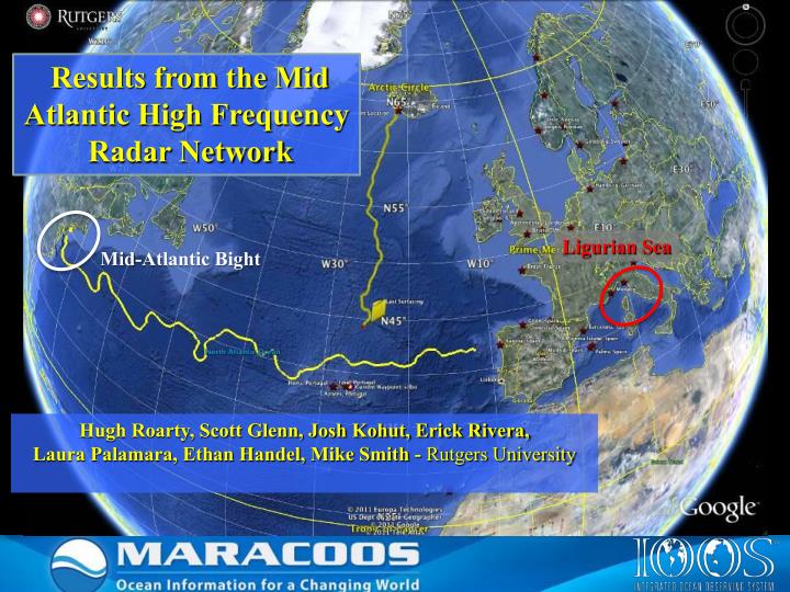
Results from the Mid Atlantic High Frequency Radar Network. Ligurian Sea. Mid-Atlantic Bight. Hugh Roarty, Scott Glenn, Josh Kohut, Erick Rivera, Laura Palamara, Ethan Handel, Mike Smith - Rutgers University. U. M iddle A tlantic R egional A ssociation C oastal

E N D
Results from the Mid Atlantic High Frequency Radar Network Ligurian Sea Mid-Atlantic Bight Hugh Roarty, Scott Glenn, Josh Kohut, Erick Rivera, Laura Palamara, Ethan Handel, Mike Smith - Rutgers University
U.. Middle Atlantic Regional Association Coastal Ocean Observing System 1000 km Cape to Cape RI Cape Cod Watersheds of the Middle Atlantic Bight To seek, discover and apply new knowledge & understanding of our coastal ocean CT MA NY 10 States PA NJ DE MD VA NC Cape Hatteras
U.S. Integrated Ocean Observing System IOOS Relationships International Component Regional Component Global Ocean Observing System Vessels - Satellite Satellite CODAR Ships/ Vessels Glider REMUS Data Vis. Modeling Leadership Education 8 Universities in MARACOOS contribute to HF Radar Network 11 Regional Associations
Rutgers University - Coastal Ocean Observation Lab MARACOOS Operations Center Vessels - Satellite Satellite CODAR Ships/ Vessels Glider REMUS Data Vis. Modeling Security Leadership Education Glider Fleet CODAR Network L-Band & X-Band Satellite Receivers 3-D Nowcasts & Forecasts
High Frequency Radar – Since 1996 14 Long-Range 7 Medium-Range 14 Short-Range 35 Total CODARs Corporate Partner: CODAR Ocean Sensors Nested Grids of Hourly Surface Current Maps ^ Combined CODAR & Satellite Products >
Long Range HF Radar Workforce Northern Operator Regional Coordinator Hugh Roarty Northern Operator Chris Jakubiak Central Operator Ethan Handel Southern Operator Teresa Garner Central Operator 2 Operators For 5 Sites Southern Operator 2 Operators For 7 Sites
Future Medium Range Network13 MHz Range ~ 80 km Resolution 2 km
13 MHz Tx/Rx Antenna Single antenna at 13 MHz Transmit and Receive Radial whips no longer needed Possible to install with no guy wires and small base
NCAR Computer Language (NCL) used to plot currents 25% temporal coverage needed at each grid point
NCAR Computer Language (NCL) used to plot currents 25% temporal coverage needed at each grid point
NCAR Computer Language (NCL) used to plot currents 25% temporal coverage needed at each grid point
Winter Spring Summer Fall 2008 2009 2010
Science Results – Tracking Hurricane Irene Hurricane Irene Approaches the MARACOOS HF Radar Network
Science Results – Tracking Hurricane Irene 39.5N 73W Surface Current Time Series > Total CurrentNear-Inertial Current Period 18 hours Hurricane Irene Approaches the MARACOOS HF Radar Network HF Radar Wave & Wind Direction Time Series >
Science Results – Tracking Hurricane Irene Hurricane Irene Approaches the MARACOOS HF Radar Network
MIDDLE ATLANTIC REGIONAL DRIVERS Tropical Storms Climate Change Ocean Circulation Critical Habitat Northeasters Population Ports
MARACOOS REGIONAL THEMES & SUCCESS STORIES 1) Maritime Operations – Safety at Sea 3) Water Quality – a) Floatables, b) Hypoxia, c) Nutrients 2) Ecosystem Decision Support - Fisheries 5) Energy – Offshore Wind 4) Coastal Inundation - Flooding
U.S. Coast Guard: Search And Rescue Optimal Planning System SAROPS Mid-Atlantic Operational Data Flow to SAROPS SAROPS User Interface SAROPS 96-Hour Search Area:HF Radar= 12,000 km2 SAROPS 96-Hour Search Area: HYCOM = 36,000 km2
U.S. Coast Guard: Search And Rescue Optimal Planning System SAROPS 1 Statistical & 3 Dynamical Data-Assimilative Forecast Models 1) STPS U. Connecticut 4) HOPS U. Massachusetts, Dartmouth 2) NYHOPS Stevens Institute of Technology 3) ROMS Rutgers University
Ecological Decision Support – Fisheries Divergent + Convergent Like Upwelling Our Approach: Develop statistical models using bottom trawl surveys and MARACOOS 3-D data to predict species distribution based on observed or forecasted MARACOOS 3-D fields. Hate Downwelling Downwelling Upwelling Downwelling Upwelling
Water Quality – Nearshore Currents Alongshore Current Nearshore currents derived from single site radial currents track the movement of water quality constituents within 3 km of the beach.
Offshore Energy – High Resolution Atmospheric Forecast validated with HF radar Spatial validation of Atmospheric Model with 13 MHz Multi-static HF Radar Array High Resolution Wind Resource 670 mhorizontal resolution Wind Development Area Expected Coverage
Enhancing the Network with Bistatics Bistatic from SEAS Transmitter Bistatic from SEAB Seasonde Backscatter
Enhancing the Network with Bistatics 3 radars can provide 6 measurements
Radial Current Vectors 13 MHz
Totals from Radials Optimal spacing should be 40 km 90 km
Totals from Radials & Ellipticals Coverage Area from only Radials
HF Radar Spectra Fixed Objects & Direct Signals Bragg Waves Bragg Waves Vessel Signal Strength (dB) Vessel Range Doppler Frequency
Test Case – Dace Reinauer Length: 134 m Beam: 21 m
Monostatic and Bistatic Detection of the Dace Reinauer Type of Vessel: Tug IMO: 8993368 MMSI: 366238710 Length: 134 m Beam: 21 m
Conclusions Mid Atlantic Long Range HF Radar Network is celebrating its 10th anniversary MARCOOS is delivering Quality Controlled Surface Current Data and Forecasts to the US Coast Guard for improved SAR HF Radar Network is helping to describe the nature of the flow in the Mid Atlantic We are also developing the dual-use capability of the radar for vessel detection