Download
1 / 16
160 likes | 177 Views
Develop a web portal for coordinating remote sensing data availability and distribution, including product documentation and gridded data products in NetCDF format. Coordinate efforts in interface procedures and overall control capability. Implement monitoring kits and update information regularly. Milestones and deliverables are outlined with a checklist provided for updating product lines, system monitoring, and documentation. Summary cards and project activities detail data variables, resolutions, time parameters, formats, sizes, and access conditions. Follow-on open issues address services, system versions, distribution reviews, user feedback, and refining functions for geographical targets and forecasting systems. Assessments include interoperability and business charters, operationality, and quality levels.

E N D
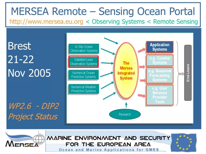
MERSEA Remote – Sensing Ocean Portal http://www.mersea.eu.org< Observing Systems < Remote Sensing Brest 21-22 Nov 2005 WP2.6 - DIP2 Project Status
WP2.6 and DIP-2 Activities To be conducted / Conducted yet (1/2) The general objective of the 2.6 task is to coordinate all efforts in remote sensing data availability and distribution. • A WWW site will be developed as a portal to the different independent systems and to facilitate the visibility and exchange of the data in a reliable and coherent manner • The portal will provide an overview of all available remote sensing data and an easy access to the data sets through a link to the relevant data distribution servers. • The second phase will tackle the problem of documenting all products(lists of products, formats, user guides, tutorials) • The second phase will tackle the problem of providing gridded data products for all mission – SST, sea ice and ocean color) in a Netcdf structure format using the same ocean convention such as COARDS/CF and distribute them in an OPeNDAP catalogue Nov 2005
WP2.6 and DIP-2 Activities To be conducted / Conducted yet (2/2) The general objective of the 2.6 task is to coordinate all efforts in remote sensing data availability and distribution. • The second phase will tackle the problem of setting up well defined or revised interface procedures (with partners and other WPs) • The WWW remote sensing data portal will berun in a shared and distributed mode. • A Mersea LAS will be implemented to federate Opendap servers. • The second phase will tackle the problem of implementing an overall control capability (monitoring kits). • The second phase will tackle the problem of running a web site to keep updated information and post new information (cf. actualities, R&D reports) Nov 2005
Check-List • Identify your product lines • Register/update your product line (discovery metadata) • Fill in/ update the system monitoring table • Update your documentation • List of products (record above information) • User manual (see template on examples on …) • User tutorial (see template and examples on ….)
User Tutorial (information on the web) – template under preparation – For more information (useful links) • Mersea Data Center web site, Product web site, Data distribution server, Viewing service • More links: cf. direct links on satellite center or projects wrt to the ocean parameter use Overview • Mission (text + image per §) • Products • Services • Satellites and useful characteristics • How we measure the « ocean parameter » of interest (SSH, SST, SSR, Sea Ice) • « Ocean parameter » usefulness for ocean monitoring • Multiple satellites for high precision « Ocean Parameter » • Applications (+ link to forecast systems, the place to input data) • References Summary Cards • ID Card:short name, version long name, hierarchy, type of product: NRT/DT • Operational card: configuration, resolution, qualification process, history file, production schedule • Quality card:indicators, metrics Products Introduction Oceanic variables Resolution Period of supply Time parameters Format Size (MB) Distribution Access conditions => Discovery metadata file Project Activities • Summary • Activities • First Year Results • Research and Development • Documentation • Presentations
WP2.6 and DIP-2 ActivitiesFollow on -Open Issues • Services & High level functionalities ? System ambition • System Versions ? & Timeframe Deploiement level • Second Distribution Review When ? What for ? • Monitoring and assessment report for phase 2 • Who are the users feedback for new products and services enhancements • Refine crosscutting functions • Products refined wrt geographical targets & forecasting systems
Assessment for V1 SystemTEP / Data Centers Overview * Follow on of Strand-1
Assessment for V1 SystemInteroperability charter - product * Quality rate => 3 levels : quality, performance, accuracy
Assessment for V1 SystemInteroperability charter - distrib * Quality rate => 3 levels : quality, performance, accuracy
Assessment for V1 SystemBusiness charter * For operationality and validation demonstration