Download
1 / 26
260 likes | 418 Views
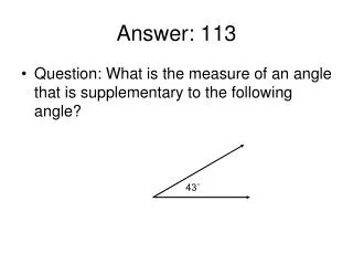
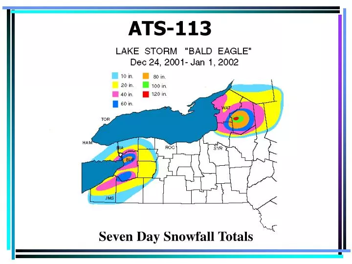
ATS-113. Seven Day Snowfall Totals. Fronts. Arise because different air masses don’t mix readily When two air masses come in contact, they retain their individual qualities The transition zone between two air masses is called a front

E N D
ATS-113 Seven Day Snowfall Totals
Fronts • Arise because different air masses don’t mix readily • When two air masses come in contact, they retain their individual qualities • The transition zone between two air masses is called a front • Can be 100s of miles long and they exist as long as the air masses remain distinct • A frontal zone is a sloping surface that separates two distinct air masses • Labeled on weather maps at the surface since that is where the differences are usually the most prominent
3D view of a generic fontal zone Fronts are boundaries between air masses of different densities! Fig. 9.13
Fronts • Classified according to the temperature changes that occur after they pass over a given location • More happens than just a temperature change • We’re going to examine what happens to pressure, temperature, wind direction, and cloudiness as a front passes over a region
Cold Front (CF) • As CF approaches • Temperature remains steady or even rises under the influence of warm southerly winds • Pressure decreases as CF approaches • Temperature then quickly drops as front passes and cold air mass dominates • Pressure rises as cold, high pressure air mass moves into the region • Winds shift from the SW to the NW • Precipitation is confined to the frontal zone • Scattered showers and T-storms • If the temperature and moisture contrast is really strong, a squall line can develop ahead of the CF
Cold Front (CF) • After the front passes • The sky clears although scattered Cumulus or stratus clouds may linger • Fronts extend above the surface • Has a steep slope • Height increases 1 km : 50-100 km away • Forces warm air it is replacing to rise rapidly • Abrupt vertical motion generates T-storms • Brief and confined to near the CF • Speed of the CF varies from nearly 0 to 31 mph • Can generate precipitation and storms 24/7
Surface weather associated with a typical cold front Fig. 9.14
3D Cross Section Through a CF 100 miles Fig. 9.15
Warm Front (WF) • As a WF approaches • Temperature remains steady or climbs slightly • Then rapidly increases during the frontal passage • Pressure drops—not as much as with CF • After passage, the air is warmer and often more humid • Pressure increases • Winds shift from Easterly to Southerly
Warm Front (WF) • Frontal surface has gentler slope • Warm frontal air slides upward over the cooler air ahead of the front • This “upgliding” is called warm air is a form of “overrunning” • Results in deep layers of stratiform clouds • Gentle rise promotes condensation and clouds, but not T-storms • Steady precip falls from the nimbostratus clouds associated with the overrunning • Can be far in advance of the WF
Warm Front (WF) • Frontal slope tends to generate stratiform clouds far in advance of the WF • CirrusCirrostratusAltostratusNimbostratus • Steady precipitation…often lasting for days • Slow moving and large scale vertical ascent • Cirrus can lead surface front by 1000 km • WF typically move ½ as fast as CF • Can lead to hazardous weather • Sleet or freezing rain • Frontal fog
Surface weather associated with a typical warm front Fig. 9.16
3D Cross Section of a WF 800 miles Fig. 9.17
Stationary Fronts • Occur when two air masses collide, but move little or none at the surface • Air aloft can still be moving • Leads to overrunning—similar, but weaker than that associated with a WF • Front is still powerful…often with strong winds aloft • Conditions that favor “Derechos” • Often leads to flooding-rain that doesn’t move!
CF, WF, and SF are all examples of the polar front • Separate air masses coming from the N and South
Occluded Fronts • Fast moving cold fronts could “catch up” with slower moving warm fronts • Forms an occlusion (Occluded Front) • While warm and cold fronts separate cold and warm air masses • Occluded fronts separate two polar air masses • Warm air mass is aloft, lifted by the interaction between the two polar air masses • There are two basic types of occlusions
Cold type—cold cP air mass digs underneath the warm and cool air masses ahead of it Warm type—cool mP and warm mT air mass overrun the cold cP air mass Weather ahead of an occluded front is similar to that with a WF Weather behind an occluded front is similar to that with a CF Fig. 9.18
Drylines • Dry cT air is drawn down from the Mexican plateau by cyclonic flow associated with storms on the lee side of the Rockies • The difference in temperature between an mT and a cT air mass might be small, but the difference in moisture is large • Provides a focus for thunderstorm development over Texas and Oklahoma in the late spring • Density differences!!
Fronts-What to look for? • Strong temperature gradient • Isotherms are close together • Strong moisture gradient • Dew points (isodrosotherms) are close together • Fronts lie in troughs of low pressure • Wind shifts along fronts • Cloudiness and precipitation
Fronts-what happens as they go by? • Pressure falls (in the troughs) and then rises in the air mass behind the front • Sharp change in temperature • Sharp change in humidity (dew point) • Rain / cloudiness • Sharp wind shift
Fronts and Cyclones • Cyclones typically have • CF to the south or west • WF to the east • The fronts meet at the center • Fronts do and don’t: • They meet at the low • They don’t go through Highs • They don’t cross • They are generally Smooth • They generally bow forward • They don’t have gaps • They ALWAYS go CF—LOW—WF