Download
1 / 40
410 likes | 708 Views
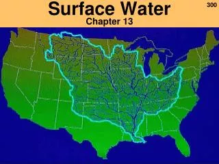
Chapter 13 – Surface Water. Hydrologic cycle. The hydrologic cycle defines how Earth’s Earth’s water supply is circulated Processes involved in hydrologic cycle Precipitation Evaporation Infiltration Runoff Transpiration. The hydrologic cycle. Sources of Earth’s water.

E N D
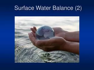
Hydrologic cycle • The hydrologic cycle defines how Earth’s Earth’s water supply is circulated • Processes involved in hydrologic cycle • Precipitation • Evaporation • Infiltration • Runoff • Transpiration
Sources of Earth’s water (saltwater) freshwater
Running water • Begins as sheetflow • Infiltration is controlled by • Intensity and duration of rainfall • Prior wetted condition of the soil • Soil texture • Slope of the land • Nature of the vegetative cover • Runoff of rain or spring snowmelt occurs in excess when soil is saturated.
Running water • Streamflow • Factors that determine velocity • Gradient, or slope • Channel characteristics including shape, size, and roughness • Discharge – the volume of water moving past a given point in a certain amount of time
Stream Changes • Changes from upstream to downstream • Factors that decrease downstream • A. Longitudinal Profile is the side-view of a stream • From head (headwaters) to mouth of stream profile flattens out • B. So gradient (slope) decreases downstream • C. channel roughness (grain size) also decreases downstream • Factors that increase downstream • A. Velocity • B. Discharge • C. Channel size all get larger
Longitudinal profile of a stream Drainage Divide Tributaries Stream capture, decapitation Distributaries And Delta Trunk Stream
Running water • Changes from upstream to downstream • Gradient and channel roughness decrease downstream • Base level and graded streams • Base level is the lowest point to which a stream can erode • Graded streams have equal erosion and deposition.
Base level and graded streams • Two types of base level • Ultimate (sea level) • Local or temporary • Changing conditions cause adjustment • Sudden extra sediment steeper gradient, faster flow erosion, sediment removed and equilibrium reestablished. • Pinched Garden Hose Analogy
Important definitions Stream - Sediment Terminology • Transport of sediment by streams • Transported material is called sediment load • Types of load • Dissolved load • Suspended load • Bed load Moves during high velocity Sandy Portion – Saltation (bouncing) Cobbles – Traction (rolling) • Capacity –maximum load stream transports • Competence – Largest particles it can move • Proportional to velocity squared
Suspended load - confluence Green & Colorado Rivers in Canyonlands, Utah
Competence • maximum particle size a stream transports • Proportional to velocity squared –K.E. • Depositionof sediment by a stream • Caused by a decrease in velocity • Competence is reduced • Sediment begins to drop out
Deposition of sediment by a stream • Channel deposits • Point bars cover bed load as meandering stream’s channel loops move • Mid-channel bars form in braided streams • Deltas • Floodplain deposits cover point bar • Natural levees – form parallel to the stream channel by successive floods over many years
Running water • Deposition of sediment by a stream • Alluvial fans • Develop where a high-gradient stream leaves a narrow valley and spreads out onto a broad plain • Slopes outward in a broad arc
An alluvial fan in Death Valley Sudden drop in competence
Stream valleys • Most common landforms on Earth’s surface • General features of stream valleys 1. Narrow valleys • V-shaped • Downcutting toward base level • Can include rapids and waterfalls
Wide Stream valleys 2. Wide valleys often include • Floodplains • Erosional floodplains • Depositional floodplains • Meanders • Cut bank and point bar • Cutoffs and oxbow lakes
Formation of natural levees by flooding Meandering Stream Flood over banks, sediment carrying water into wide area, greater drag, lower velocity, load drops
Erosion and deposition along a meandering stream Low v Meanders get more extreme with time. Deposition at point bar keeps up with erosion at cutbank
Channel moves in direction of cutbank Pointbar advances as crossbed drapes Cut off loops silt up as oxbow lakes Old cut-off loop fills with mud, an oxbow lake Meandering Stream OxBow Floodplain http://hays.outcrop.org/gallery/rivers/arid_meander?full=1
Point Bar Sequence Fines of Floodplain Crossbeds of Point Bar Gravel of bed Erosion
Development of an oxbow lake by meander cutoff Runoff silts up the oxbow
Delaware Water Gap • Incised meanders • Meanders in steep, narrow valleys • Caused by a drop in base level or uplift of region
Stream Terraces • Remnants of former floodplain • River adjusts to drop in base level by down cutting
River meanders across floodplain Base level drops, or region uplifts. Terrace forms in floodplain Further incision cuts a new terrace Why? Steeper gradient causes cuttoffs, stream straighter, cuts down narrower area.
Floodplain Mudcracks indicate drying events. Geologists can determine if rocks overturned.
Mud Cracks: clay layer shrinks during drying, cracks fill with younger sediment in next flood
Braided Streams • Occur where bed (sediment) load is very high. Often big boulders in the stream. • Many channels because mid-channel bars split the stream • Adjacent to mountains in high rainfall areas
Deltas • Occur where stream hits slow water • Bedload dropped • Deposits build out into lake or sheltered sea, extending the length of the river • Consists of three types of beds Topset beds Foreset beds Bottomset beds
Deltas have strata deposited in a characteristic geometry Topsets, Forsets and Bottomsets Actually much more complex: many distributary channel deposits
River delta distributary channels change location with time General trend: Delta builds Seaward. If Floodwaters happen to reach the sea via a shortcut, they flow by the shorter (steeper) path cutting a new channel, abandon old