Download
1 / 27
290 likes | 489 Views
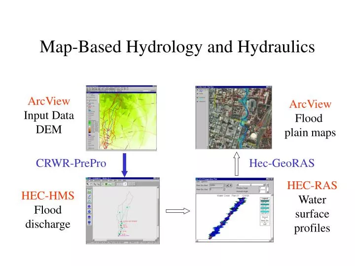
Map-Based Hydrology and Hydraulics. ArcView Input Data DEM. ArcView Flood plain maps. CRWR-PrePro. Hec-GeoRAS. HEC-RAS Water surface profiles. HEC-HMS Flood discharge. Austin Digital Elevation Model. Waller Creek. Austin Watersheds. CRWR-PrePro. Digital Elevation Model

E N D
Map-Based Hydrology and Hydraulics ArcView Input Data DEM ArcView Flood plain maps CRWR-PrePro Hec-GeoRAS HEC-RAS Water surface profiles HEC-HMS Flood discharge
Austin Digital Elevation Model Waller Creek
CRWR-PrePro Digital Elevation Model Stream Map ArcView-based preprocessor for HEC-Hydrologic Modeling System (HEC-HMS) Control point locations Soil and Land Use Maps HMS Basin File
Selected Watersheds and Streams Mansfield Dam Colorado River
HMS Schematic Prepared with CRWR-PrePro Mansfield Dam Colorado River
HMS Results Watershed 155 Junction 44
GIS-Based Flood Modeling • Terrain analysis using Digital Elevation Models • Flood hydrology model for the Austin region • Creating flood plain maps for Waller Creek • Real time flood emergency management
Map-Based Hydrology and Hydraulics ArcView Input Data DEM ArcView Flood plain maps CRWR-PrePro AvRAS HEC-RAS Water surface profiles HEC-HMS Flood discharge
Colorado River Network 1:100,000 scale Developed from EPA River Reach File 3 (the predecessor of the NHD)
City of Austin Stream Network Developed from 1”=100’ Capco Areal photogrammetry 1:1200 scale
Stream Definition: Waller Creek Austin Watersheds with Streamsderived from Aerial Photographs Streamlines generated by the aerial photographs are not always continuous.
Information for Correcting Stream Network • DEM • Contours • Storm sewers • Orthophotos
Resulting Corrected Stream • Subsequent steps: • Verification of corrected streams by flood hydrologists. • Running “tracer” program to connect arcs. • Burning of streams into DEM.
Map-Based Hydrology and Hydraulics ArcView Input Data DEM ArcView Flood plain maps CRWR-PrePro AvRAS HEC-RAS Water surface profiles HEC-HMS Flood discharge
HEC-RAS: Background • River Analysis System model of the U.S. Army Corps of Engineers • Input = cross-section geometry and flow rates • Output = flood water elevations Cross-Section Schematic
Waller Creek Watersheds Network Channel
HEC-RAS: Cross-Section Description • Points describe channel and floodway geometry • Bank station locations • Water surface elevations and floodplain boundaries
HEC-RAS: Output Graphical Text File