Download
1 / 1
20 likes | 306 Views
Q. Q sed. Landslide Susceptibility Mapping to Inform Land-use Management Decisions in an Altered Climate Muhammad Barik and Jennifer Adam Washington State University, Department of Civil & Environmental Engineering, Pullman, WA.

E N D
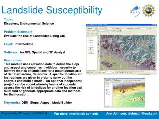
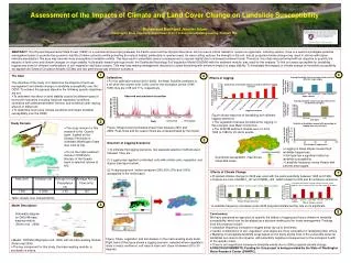
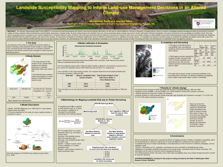
Q Qsed • Landslide Susceptibility Mapping to Inform Land-use Management Decisions in an Altered Climate Muhammad Barik and Jennifer Adam Washington State University, Department of Civil & Environmental Engineering, Pullman, WA. ABSTRACT: The Olympic Experimental State Forest (OESF) is a commercial forest lying between the Pacific coast and the Olympic Mountains. As this area is critical habitat for numerous organisms, including salmon, there is a need to investigate potential management plans to promote the economic viability of timber extraction while protecting the natural habitat, particularly in riparian areas. As clear-cutting reduces the strength of the soil, and as projected climate change may result in storms with higher intensity precipitation, this area may become more susceptible to landslide activity. This may result in potentially severe consequences to riparian habitat due to increased sediment loads. Therefore, this study was performed with the objective to quantify the impacts of land cover and climate changes on slope stability. A physically-based hydrology model, the Distributed Hydrology Soil Vegetation Model (DHSVM) with the sediment module, was used for this analysis. To map areas susceptible for landslides, logging was done for different combinations of soil, vegetation and slope classes. To investigate the impacts of climate change on landslide susceptibility we applied downscaled output from two General Circulation Models (GCMs) with two greenhouse gas emission scenarios. An understanding of the areas most vulnerable to landslides in an altered climate and due to timber harvesting will help in the development of sustainable forest management practices. 6.Landslides and Harvesting • 1.The Goal • 4.Model calibration & Evaluation • The objective of this study is to predict the long term effects of • timber harvesting under projected climate change on slope stability. • The overarching goal of this approach is to develop a decision • making tool that can be used by forest managers to make long-term • planning decisions. • The figure on the left shows an susceptibility index calculated by weighting method and classified into there classes. • 1990 logging scenario detected by Landsat-5 image, and 8yrs(1990-1997) of historic landslides were projected on the map and they showed significant relationship(see table on right). 2.Study Domain • Figure: Observed and simulated stream flow between 2001 and 2004. Peak flows and dry season • flows are underestimated by the model. • For the calibration period (2001-2005),the Nash Sutcliffe coefficient is 0.62 while the volume error is 8%; and for the evaluation period (1995-1999) they are 0.58 and 11%, respectively. • For evaluation of the mass wasting module, we compared observed and simulated landslide area for storms occurring in 1985 and 1981. • The study domain for this • research is the Queets basin, located on the Olympic Peninsula in northwest Washington State (see inset at top). • The DHSVM mass sediment module was applied to a select tributary of the Queets basin (shown at left). • The table above shows number of historical landslides in the • harvested areas of the basin for different landslides susceptibility • zones. Higher range shows higher number of landslides. 7.Results of climate change From the table we can see that the model simulations were close to historical landslides of 1985 and 1981. • Projected climate change for 2045 was used with the same possibility between 1984 and 1990. • Outputs are from CGCM3.1_t47 and CNRM_cm3 GCM models for A1B and B1 emission scenarios. • Results obtained for these two models are averaged. • Analysis showed for 2045 projected climate areas with high landslide risk increased on average 7.1% for B1 and 10.7% for A1B carbon emissions scenarios. b • 5.Methodology for Mapping Landslide Risk due to Timber Harvesting Table: Queets river characteristics DHSVM Hydrology Model Figure (a) shows the landslides susceptibility classes for Queets with timber harvesting in the basin for historic climate. Red marks in Figure (b) & (c) show new areas with Increased susceptibility level due to climate change. (b) and (c) figures are respectively for A1B &B1 carbon emission scenarios. c 3.Model Description a A weighting factor (Wf ) is applied to each thematic layer (e. g. slope, soil, elevation, vegetation) to calculate the vulnerability, according to the following method: • Model: DHSVM (Wigmosta et al. 1994) with its mass wasting module (Doten etal.2006) • The key component for this study, the mass wasting module, is stochastic in nature. Soil, vegetation, DEM and mask file input at 150m resolution Meteorology Input c DHSVM Mass Wasting Module for 10m Resolution Wi = the weight given to a certain parameter class (e.g. a soil type, or a slope class). Densclas = the landslide density within the parameter class. Densmap = the landslide density within the entire map. Npix(Fi) = number of pixels, which Contain landslides, in a certain parameter class. Npix(Ni) = total number of pixels in a certain parameter class. Run Mass Wasting Module for historical case RunMass Wasting Module for wide-spreadlogging in different slope, elevation, soil and vegetation classes • 8.Conclusions • We have presented an approach to quantify the effects of logging and future climate on landslide susceptibility, which can be developed as a decision-making tool for forest management. Findings from this analysis include: • Landslide frequency increases substantially in harvested areas and the increment is related to geography, soil and vegetation types. • Certain combinations of soil, vegetation, and slopes are more vulnerable to landsliding than others. • Mapping of susceptible landslide areas based on the study shows vulnerable areas for timber harvesting. This information can be used for long-term forest management planning. • For 2045 projected climate new areas come under high susceptibility class, thus climate change should be includes for long term planning. • ACKNOWLEDGEMENTS: Funding for this project is being provided by the State of Washington Water Research Center (SWWRC). Weighting factor (Wf) calculated for each cell of the basin and classified Compared to historical landslides Schematic diagram for DHSVM mass wasting module (Doten et al., 2006) Landslides risk zoning map for timber harvesting