Download
1 / 4
40 likes | 181 Views
It’s All About the Snow In the Basin! (days with Uintah Basin snow coverage determined from MODIS). Mid-February 2009. Vernal -2.0 ⁰ C (+ 2.0 ) Salt Lake City 2.5 ⁰ C (+ 1.0 ) 700 mb ( +0.50 ) Snow days 5. Mid-February 2010. Vernal -8.0 ⁰ C ( -4.0 )

E N D
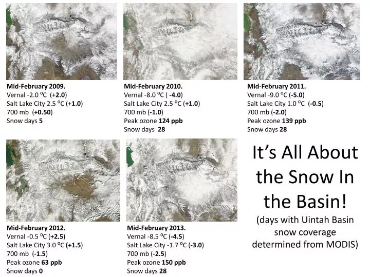
It’s All About the Snow In the Basin!(days with Uintah Basin snow coverage determined from MODIS) Mid-February 2009. Vernal -2.0 ⁰C (+2.0) Salt Lake City 2.5 ⁰C (+1.0) 700 mb (+0.50) Snow days 5 Mid-February 2010. Vernal -8.0 ⁰C ( -4.0) Salt Lake City 2.5 ⁰C (+1.0) 700 mb (-1.0) Peak ozone 124 ppb Snow days 28 Mid-February 2011. Vernal -9.0 ⁰C (-5.0) Salt Lake City 1.0 ⁰C (-0.5) 700 mb (-2.0) Peak ozone 139 ppb Snow days 28 Mid-February 2012. Vernal -0.5 ⁰C (+2.5) Salt Lake City 3.0 ⁰C (+1.5) 700 mb (-1.5) Peak ozone 63 ppb Snow days 0 Mid-February 2013. Vernal -8.5 ⁰C (-4.5) Salt Lake City -1.7 ⁰C (-3.0) 700 mb (-2.5) Peak ozone 150 ppb Snow days 28
Max and Min Temperature Climo for SLC (red) and Ouray (blue) 1981-2010 • Both basins climos show ‘cold pools’ resulting in colder December-February average temperatures than would be the case at mid-slope locations. • The ‘cold pool’ climatology is colder in Ouray than SLC • during the Dec-Feb period • with nocturnal inversions • particularly stronger • Hypothsized cause the longer duration of Uintah Basin CAPs and associated snow cover Max temp Temp C⁰ Min temp Jan Feb Mar Apr May Jun Jul Aug Sep Oct Nov Dec
Is there an East-West Interbasin Flow Resulting From Snow -‘Less’ West Slope or Dynamic Downslope Effects? Typical snow-free downslope zone Landsat 30 Jan 2009