Download
1 / 12
120 likes | 220 Views
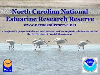
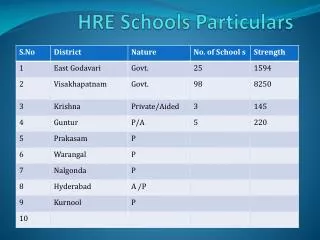
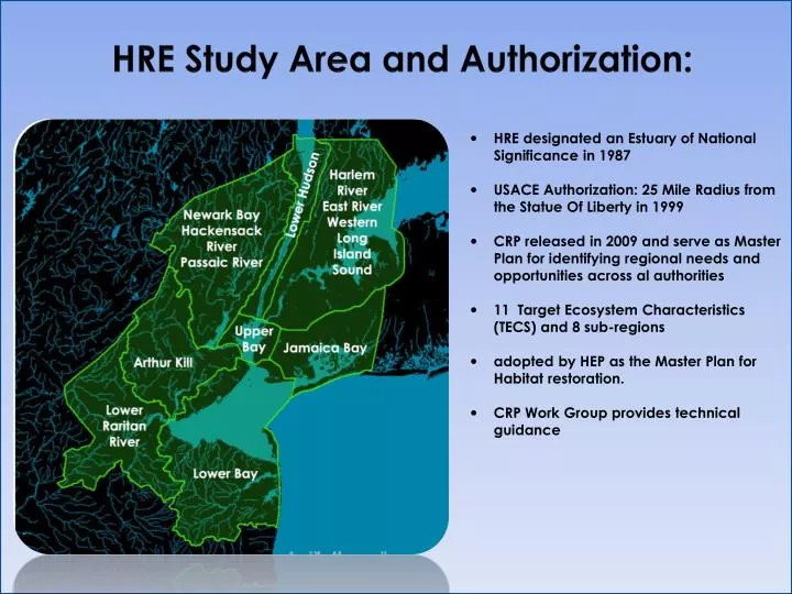
HRE Study Area and Authorization:. HRE designated an Estuary of National Significance in 1987 USACE Authorization: 25 Mile Radius from the Statue Of Liberty in 1999 CRP released in 2009 and serve as Master Plan for identifying regional needs and opportunities across al authorities

E N D
HRE Study Area and Authorization: • HRE designated an Estuary of National Significance in 1987 • USACE Authorization: 25 Mile Radius from the Statue Of Liberty in 1999 • CRP released in 2009 and serve as Master Plan for identifying regional needs and opportunities across al authorities • 11 Target Ecosystem Characteristics (TECS) and 8 sub-regions • adopted by HEP as the Master Plan for Habitat restoration. • CRP Work Group provides technical guidance
Tributary Connection TEC • Enhance the health and connectivity of tributaries to estuary • ~1600 miles of Streams • ID Impediments/Degradations and opportunities for restoration • Sub-Work Group from CRP Workgroup formed to provide technical guidance to one aspect: Physical barriers to fish migration and spawning ability.
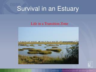
Identifying Opportunities for Barrier Removal and Fish Passage Improvements within the Hudson-Raritan Estuary List all national authorities…why HRE is USACE important HEATHER Presented by Diana Kohtio, USACE June 5, 2012 Steinberg et al. , 2004. Health of the Harbor.
Target Species Images: NYS DEC- http://www.dec.ny.gov/ ASMFC 2012 River Herring Stock Assessment
Target Species alewife blueback herring striped bass American shad DataSources: Pisces Conservation LTD. 2008 NYS DEC- http://www.dec.ny.gov/
Tributary Connection Opportunities Impaired Water
Identify and Map • Physical Barriers • Attributes: • Location • Owner • Dam Type • Purpose • Year Completed • Year Modified • Dam Sources: • National Geospatial Agency, • USACE National Inventory of Dams • NYDEC Dam Safety • NJDEP Dam Safety • USACE National Inventory of Levees • Culvert Sources: • USGS National • National Hydrographic • Dataset (NY, NJ) • Dam Length • Dam Height • Max Discharge • Hazard • Spillway Type • Condition
Habitat- Water Quality & Hydrology Habitat- Existing Habitat • EPA Storet: EPA's repository of water quality monitoring data collected nationwide by water resource management groups. • USGS Stream Gage: Continuously recorded physical and chemical characteristics. • EPA 303 (d): Impaired waters data lists water ways too polluted or otherwise degraded to meet the state water quality standards. • DEP Known Contaminated Sites: Siteswhere contamination of soil or ground water has been confirmed at levels equal to or greater than applicable standards. • USACE National Inventory of Levees • State and Local CSO inventories • USGS Land Cover and Land Use: Data activities range spatially and temporally, from local to global scales and includes historical, current and future timeframes. • USFWS National Wetlands Inventory: Provides current geospatially referenced information on the status, extent, characteristics, and functions of wetland, riparian, deepwater, and related aquatic habitats in priority areas.
Historic Reports • Zich, H.E. 1977. The Collection of Existing Information and Field Investigations of Anadomous Clupeid Spawning in New Jersey. NJ Department of Fish, Game and Shellfisheries. • Byrne, Don. 1986. Anadromous Herring Run Restoration. NJ Department of Environmental Protection ; Division of Fish, Game and Wildlife; Bureau of Marine Fisheries. • Durkas, S.J. 1991. Impediments to the spawning success of anadromous fish in tributaries of the NY-NJ Harbor Watershed. American Littoral Society. • Durkas, S.J. 1993. A guideline to restore anadromous fish runs in selected tributaries of the NY/NJ harbor watershed. American Littoral Society. • Schmidt, R.E. and Cooper, S. 1996. A Catalog of Barriers to Upstream Movement of Migratory Fishes in the Hudson River Tributaries. • Halavik, T and Orvis, C. 1998. Report to the Hudson River/New York Bight Ecosystem Team Fish Passage Subgroup. US Fish and Wildlife Service.
Next Steps – Migratory Barriers • Complete merge of barrier databases to achieve a comprehensive list of dams, levees and culverts within the HRE Study Area. • Develop a scalable algorithm to identify the most relevant fish passage restoration opportunities amongst this comprehensive list. • Based on habitat, biological (eg. life history needs, potential behavioral issues, swimming performance), structural and landscape attributes- • Can be built upon (if further funding and data become available in the future)
Next Steps - HRE • Final CRP • updated/expanded restoration Opportunities • Master Plan to guide regional Planning • Across all authorities/programs • restoration, preservation and mitigation • Draft Feasibility Report • Recommended Opportunities for Corps Implementation • Subject to NAD/HQ and Agency/Public Review • Final Feasibility Report. • Goes to Congress for programmatic Authorization • Specific Restorations implemented as Sponsors/Funds allow • )