Download
1 / 35
350 likes | 490 Views
US NSDI Initiatives: State Activities Geospatial One-Stop Future Directions. ASPRS Spring Meeting Denver, CO 25 May 2004 Ivan DeLoatch, Staff Director Alan R. Stevens, International Program Director US Federal Geographic Data Committee (FGDC) www.fgdc.gov +703-648-5119.

E N D
US NSDI Initiatives:State ActivitiesGeospatial One-StopFuture Directions ASPRS Spring Meeting Denver, CO 25 May 2004 Ivan DeLoatch, Staff Director Alan R. Stevens, International Program Director US Federal Geographic Data Committee (FGDC) www.fgdc.gov +703-648-5119
US Spatial Data Infrastructure:At the Crossroads & moving forward US Federal Geographic Data Committee (FGDC) • Evolution (nationally) • How to keep the pressure on …? • How to percolate it down to the working level? • State initiatives • Goespatial One-Stop (e-gov) • Future Directions • About the track
Create a National Spatial Data Infrastructure (NSDI) ……… To encourage the collection, processing, archiving, integration, and sharing of geospatial data and information using common standards and interoperable systems and techniques ….. and accessible via the web
What is the Federal Geographic Data Committee? Really two answers…. • Body of people facilitating the creation of the NSDI within the US • Committee of many federal, state, academic agencies and the private sector working to actually build the NSDI
The Federal Geographic DataCommittee • Chartered in the early 1990s • Federal – 19 cabinet level agencies & offices • Many states, regional, & local governments participate • Along with the private sector, NGOs, and Academia
FGDC Steering CommitteeCabinet Officers and Agencies: • Interior (Vice Chair) • Agriculture • Defense • Energy • Health and Human Services • Housing and Urban Development • Justice • State • Transportation
FGDC Steering CommitteeCabinet Officers and Agencies: • Environmental Protection • Emergency Management • Library of Congress • NASA • Archives and Record Service • Office of Management and Budget (Vice Chair) • Commerce • National Science Foundation • Tennessee Valley Authority • General Services Administration
Federal Geographic Data Steering Committee • It’s not just federal……. • States • Counties • Municipalities • Non-Governmental Organisations • Industry
NSDI … so where are we today?Strong high-level political federal support • FGDC starts late 1980s – early 1990s • High level political support • OMB Circular A-16 • NSDI Presidential Executive Order 1994 • Secretarial involvement in the FGDC • Extensive partnerships established • Standards -- nationally, internationally • Clearinghouse network • Open policy for federal spatial data
The Federal Geographic DataCommittee …. what’s new? • Major focus within the Federal Government • An effort to reach into states and communities • Need a sustained effort to drive the concept and application to the states and local governments
The Federal Geographic DataCommittee …. what’s new? • State Initiatives • Geospatial One-Stop • E-gov • E-com
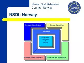
WHAT do we mean by state initiatives ? In the US, it is a collaborative process for a state to organize the way it produces, archives, and shares its digital geospatial assets ….. a State SDI
Why do we want states involved? • Helps all levels of government fulfill their missions • Develops links between: • The US FGDC and the State and its data • The State and the County/City data • Supports and facilitates: • The US NSDI in concept and operation • Geospatial One Stop • GSDI ……. local to global
What is it not?? • It is not a new agency • It is not more bureaucracy • Probably not looking for more money • Although ………………???? • Not separate from NSDI or FGDC!!
What Do State Teams Do? • Address institutional barriers • Identify most effective ways to collect, maintain and distribute data • Designate data stewards • As best we can to fit into NSDI recommendations including: • Metadata creation • Clearinghouse development • Framework • etc
The Federal Geographic DataCommittee …. what’s new? • State Initiatives • Geospatial One-Stop • E-gov • E-com
What is the President’s management agenda? President’s management agenda : …… pathway to a government that delivers results…. Making it … easier, faster, cheaper…. for all levels of government and public to access geospatial data and information
What is the President’s management agenda? E-Government ….. Use of digital technology to transform government operations to improve efficiency and effectiveness • It is a means to an end; not an ‘end’ in itself……….
What is Geospatial One-Stop? Goal ….. Provide federal and state agencies with a single point of access to geographic information reducing/eliminating redundant data collection and archives. Milestones ….. • Identify federal inventory of framework data • Focus on standards • Deploy Geospatial 1-stop portal
So how does does all of this relate to the NSDI??? • One and the same……… • Another way to promote and drive some of the basic cannons of the NSDI • Really a mechanism to: • keep the pressure on ……. • To keep the principles of the program in front of the NSDI advocates and the user community • To percolate the concepts to the lowest levels
FGDC/NSDI Future Directions Why do we need to …….? • Added one-stop • 1994 & 97 strategic plans developed • New staff director • Really need the local data holdings to adopt • Questions about the coordination of NSDI, GOS, and CTM • Attention to Homeland Security • Where do we want to be in 2014?
FGDC/NSDI Future Directions What is the process????? • FGDC staff built straw-man • Involve other stakeholders • Consumed the entire FGDC coordination committee
FGDC/NSDI Future Directions VISION: Current and accurate geospatial data will be available to contribute locally, nationally, and globally to economic growth, environmental quality, and stability, and social progress
FGDC/NSDI Future Directions 1. Forging partnerships with a purpose Expand the governance model
FGDC/NSDI Future Directions 2. Making framework real …generating framework data themes that will include collection, documentation, access, and utilization of data.
FGDC/NSDI Future Directions 3. Communicating the Message …recognized across the nation as the primary source for the availability and use of reliable spatial data
Create a National Spatial Data Infrastructure (NSDI) ……… To encourage the collection, processing, archiving, integration, and sharing of geospatial data and information using common standards and interoperable systems and techniques ….. and accessible via the web
So what are we doing here this week….?? Nine session Track on: • NSDI • Geospatial One-Stop • Cooperative Topo Map Program • NSDI Cap grants • Global Spatial Data Infrastructure (GSDI) • Global Sustainability
So what are we doing here this week…..? Tuesday • 10:30 AM • NSDI • National Map • CAP Grants • 1:00 PM • NSDI & the utility companies • A Japanese case study • GSDI
So what are we doing here this week…..? Tuesday • 2:30 PM • CAP grant panel • 5:00 PM • Two examples of SDI applications in the international community
So what are we doing here this week…..? Wednesday • 9:30 AM • Overview of Geospatial One-Stop • 1:30 & 3:00PM • GOS implementation and demo
So what are we doing here this week…..? Thursday • 9:30 AM • A new vision for the National Map Program • 11:00 • Implementing the National Map Strategy
Additional Information • www.fgdc.gov Federal Geographic Data Committee • www.opengis.org Open GIS Consortium Ivan Deloatch, Staff Director, US FGDC Alan Stevens, International Program Mgr. FGDC 590 National Center 12201 Sunrise Valley Drive Reston, Virginia 20192 USA Ideloatch@fgdc.gov Astevens@gsdi.org