Download
1 / 17
170 likes | 193 Views
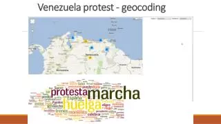
Geocoding plays a crucial role in effective addressing systems for municipalities, 911 services, and businesses. This overview explains how addressing typically follows patterns, theoretical standards, and practical considerations in the U.S. Understand how geocoded addresses work for emergency services and the importance of accurate street layers in geodatabases. Learn about creating and editing street files for proper address assignment.

E N D
Geocoding This is a very big issue for municipalities, 911 and business.
An overview, once again. N Even City Center Odd Addressing typically follows common patterns in U.S.
Oak St. 100 200 198 299 199 101 298 201 Cedar St. Elm St. Addressing can follow theoretical standards
Oak St. 100 198 299 200 199 101 201 298 Cedar St. Elm St. For example: 221 Oak St. can be placed approximately ¼ of the length of the block. Addresses are matched according to the theoretical standards
Oak St. 100 200 117 234 119 101 235 201 Cedar St. Elm St. In reality, most streets do not have theoretical address ranges. It depends on the age of the neighborhood, size of lots, etc.
Most street files have theoretical ranges, but some municipalities use actual ranges. Oak St. 100 117 234 200 119 101 201 235 Cedar St. Elm St. So the example 221 Oak St. is placed in its actual location, near the end of the block.
Remember, street layers are shapefiles or geodatabases and therefore have “geography” – they have coordinates.Therefore, when you match an address, the address now has geography.
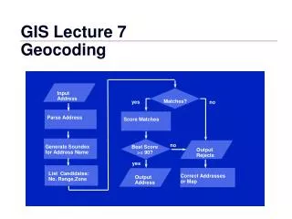
How 911 works: • A landline (not a cell phone) is attached to an address • An address can be matched to an address ranged street file • When the operator receives a call, the phone number accesses a database with and address that is then matched to a street file.
Call to 911 911 Operator connects to database with citizen’s phone number Citizen Phone number is tied to address – 221 Oak St.
You must become familiar with the layer attribute table There are 3 road name fields in the Denton County 911 layer.
Editing road line features for use in address ranged purposes. If you do not create intersections while editing the street file, you only have 4 features and 4 records in the above graphic. You cannot assign address ranges to the above file.
When creating lines, you must put in nodes at intersections of where lines break into segments.