Download
1 / 71
730 likes | 1.22k Views
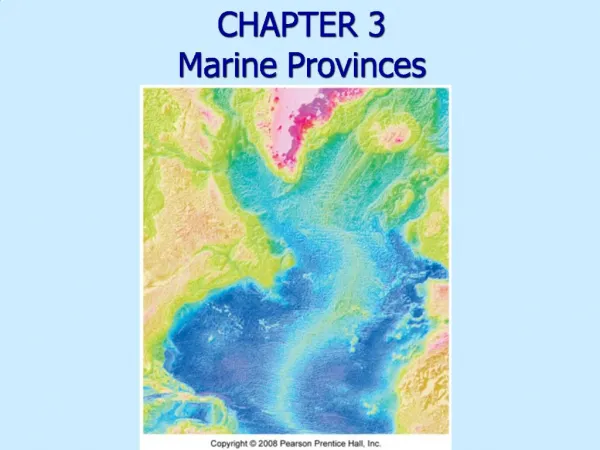
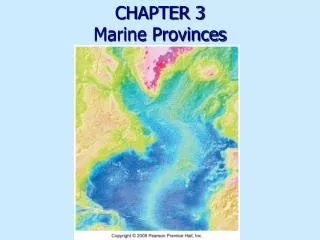
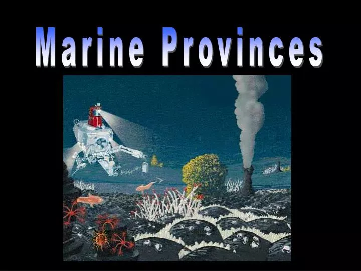
Marine Provinces. Bathymetry. Bathymetry is the measurement of ocean depths and the charting of the shape or topography of the ocean floor The ocean floor is a highly varied terrain that contains many interesting features Early methods used a long weighted line (called a sounding line).

E N D
Bathymetry • Bathymetry is the measurement of ocean depths and the charting of the shape or topography of the ocean floor • The ocean floor is a highly varied terrain that contains many interesting features • Early methods used a long weighted line (called a sounding line)
Bathymetric techniques • Echosounders send sound through water to determine water depth and sea floor features
Bathymetric techniques • Side-scan sonar uses a “fish” towed behind a ship to give a more detailed picture of the sea floor
Bathymetric techniques • Low frequency sound is used to determine structure beneath the sea floor
Bathymetric techniques • Satellites measure sea surface elevation, which mimics sea floor bathymetry
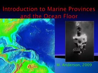
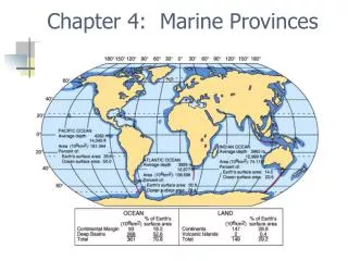
Topography of the Ocean Floor Continental Margin- submerged outer edge of the continent. Includes the continental shelf and slope.
Continental shelf • Continental slope • Continental rise • Abyssal plain • Abyssal hills • Features of the Underwater World • Submarine canyon • Seamount • Guyot • Ridge • Trench
slope continental shelf rise abyssal plain abyssal hills ridge transform fault
Continental Shelf: • shallow submerged extension of the continent • more like the continent than the ocean basin • important for mineral and oil deposits • 7.4% of Earth’s ocean area
Continental slope: • the transition between the gently descending cont. shelf and deep-ocean basin • generally, 4 - 25o slope, 12 miles wide, 12,000ft deep • Continental Rise: • accumulation of sediment from turbidity currents • like an avalanche
Shelf width depends on: • proximity to plate boundary (passive vs active margin) • sea level • fast moving ocean currents
Passive versus active continental margins • Passive margin • No plate boundary • Shelf • Slope • Rise • E.g., eastern coasts of N. and S. America • No volcanism
Passive versus active continental margins • Active margin • Plate boundary • Convergence zone • volcanism, many earthquakes, and active mountain building • E.g., California, Chilean (e.g., Peru, Chile), Marianas (e.g., Japan, Marianas)
Abyssal plain: • flat featureless expanses of sediment formed by suspension settling • common in Atlantic • Abyssal hills: • small sediment covered extinct volcanoes • < 650 ft high
Sea mount: • volcanic projections that don’t rise above the surface of the sea • circular or elliptically shaped • many form at hot spots
Submarine canyons: • Canyons that cut into continental shelf • Turbidity currents carve submarine canyons into the slope and shelf
Submarine canyons and deep-sea fans • Moves sediment movement from the continents into the deep-sea via turbidity currents • Debris from turbidity currents creates graded bedding deposits and deep-sea fans
Ridges: mountainous chain of young basaltic rock at the active spreading center of the ocean
The Mid-Atlantic Ridge • Traverses the center of the Atlantic Ocean • Contains a central down-dropped rift valley • Surfaces in Iceland
Features of the mid-ocean ridge • Rift valleys • Form when plates split apart • Down-dropped areas associated with faults and earthquakes
Trenches: arc-shaped depression in the deep ocean floor • Formed by plate convergence • Associated with volcanic arcs • Island arc • Continental arc • Most active geologic feature on earth
Ocean trenches • Most trenches are in the Pacific Ocean
Ocean sediment • Particles of organic or inorganic matter that settle through the water column and accumulate in a loose, unconsolidated form on the ocean floor • Layers represent a record of Earth history, including: • Movement of tectonic plates • Past changes in climate • Ancient ocean circulation patterns • Cataclysmic events
Collecting ocean sediment • Specially designed ships collect cores by rotary drilling • Cores allow scientists to analyze ocean sediment
Sediment origin & composition • Origin: • Weathering and erosion • Activity of living organisms • Accumulation of dead organisms- oozes • Volcanic eruptions • Chemical processes within the water itself • Space debris • Composition: • Boulder >256mm Sand 0.062-2mm • Cobble 64-256mm Silt 0.004-0.062mm • Pebble 4-64mm Clay <0.004 • Granule 2-4mm
Sources of Sediment • Terrigenous: • Continental runoff- desert sand blows off continent to ocean • Volcanic eruptions- dust and magma • Rivers- washout of sediment Mt. St. Helens
Biogenous: • Mostly calcareous and siliceous • Abundant where ample nutrients encourage high biological productivity • Parrotfish • Oozes: pelagic sediment • containing >30% by volume • microorganism shells
Biogenous sediment composition • Microscopic biogenous tests are composed of 2 main chemical compounds: • Silica (SiO2) including opal (SiO2 · nH2O) • Diatoms (algae) • Radiolarians (protozoan) • Calcium carbonate or calcite (CaCO3) • Coccolithophores (algae) • Foraminifers (protozoan)
Calcareous Oozes Coccolithophores Foraminifers pteropod
Siliceous Oozes radiolarian diatom
Biogenous ooze turns to rock • When biogenous ooze hardens and lithifies, can form: • Diatomaceous earth (if composed of diatom-rich ooze) • Chalk (if composed of coccolith-rich ooze) Chalk cliffs of southern England
Distribution of biogenous ooze • Most biogenous ooze found as pelagic deposits • Factors affecting the distribution of biogenous ooze: • Productivity (amount of organisms in surface waters) • Destruction (dissolving at depth) • Dilution (mixing with lithogenous clays)
Hydrogenous sediment • Hydrogenous sediment forms when dissolved materials come out of solution (precipitate) • Precipitation is caused by a change in conditions including: • Changes in temperature • Changes in pressure • Addition of chemically active fluids
Types of hydrogenous sediment • Manganese nodules • Phosphates • Carbonates • Metal sulfides • Evaporite salts
Magnesium nodules: • 1st discovered by Challenger expedition (1873-76) • 16 million tons accumulate each year • Growth rate: 1-10 mm/million years • Need nuclei to form • Mining has not developed because: • Low international market price for metals • Unresolved legal ownership problems • Technical costs and development • Effect on hydrothermal vent communities unknown Mining manganese nodules
Cosmogenous sediments: • Extraterrestrial in origin • Two main types: • Microscopic space dust • Macroscopic meteor debris Diatoms (algae) • Forms an insignificant proportion of ocean sediment tektites
Studying sediments • Learn about past climates • Ocean circulation • Plate tectonics • O2 isotope stratigraphy: • O216 (most abundant): O218 (next abundant) • O216 has higher vapor pressure • At a given time when a shell forms in cold water, more O218 goes in relative to O216
Map of the World Ocean showing generalized distribution of the principal kinds of sediment on the ocean floor
Deep Ocean Characteristics • Cold • Still • Stable • Dark • Essentially no productivity • Sparse Life • Extremely high pressure • Little food
Potential Food Source for Deep Sea Organisms Deep sea orgs are dependant upon surface production from: • Dead phytoplankton, zooplankton, fish, mammals • Fecal pellets and crustacean molts • Macrophyte detritus • Animal migrations