Download
1 / 35
350 likes | 512 Views
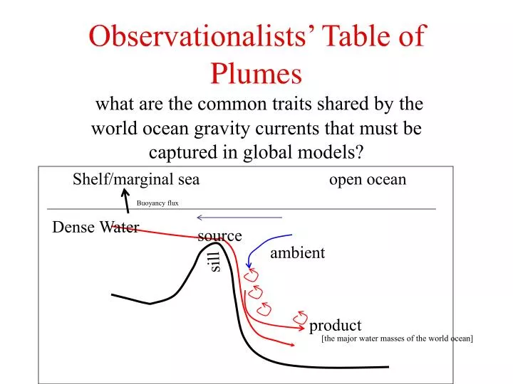
Observationalists’ Table of Plumes. Shelf/marginal sea open ocean. Buoyancy flux. what are the common traits shared by the world ocean gravity currents that must be captured in global models?. Dense Water. source. ambient. sill. product. [the major water masses of the world ocean].

E N D
Observationalists’ Table of Plumes Shelf/marginal sea open ocean Buoyancy flux what are the common traits shared by the world ocean gravity currents that must be captured in global models? Dense Water source ambient sill product [the major water masses of the world ocean]
Denmark St cool Faroe Bank Med Sea Salty/warm Red Sea Weddell Sea Really cold Ross Sea
Basic Properties • Source waterthe water just before descent [that is: at the sill] • Product water at the point that entrainment ceases [plume becomes a 'normal' quasi-isobath following flow]. • Ambient water the water just above the cap of the plume…i.e what is being entrained.
r Basic Properties z r1 u1 h r2 u2 H • Transport, Sv source, product • Velocity, m/sec source, product • Thickness, H from sea floor to mid-way in the uppermost cap [where the T/S properties begin to deviate from the ambient stratification] • Interfacial thickness, h • Thermbaric Parameter [importance?] Dr = r2 - r1 Du = u2 - u1
r The Numbers z r1 u1 h r2 u2 H Dr = r2 - r1 Du = u2 - u1
Southern Ocean: AABW Weddell Sea Ross Sea There are other sites around Antarctica that deep and bottom water form. AABW formation sites vary in topography: some canyon free, others canyon steered
Ross Sea • Western: high salinity, dense • Central: lower salinity, ice shelf water [<-2°; thermobaric]
Internal Froude ≈ 0.7 to 1.2 Gordon, A. L.,et al. (2004), Energetic plumes over the western Ross Sea continental slope, GRL Over the upper slope the benthic layer is composed of roughly 70% source water. Over the mid-slope the benthic layer is warmer and less saline due to entrainment of LCDW, with approximately a 30% source water. From benthic layer thickness increase, /S and CFC changes suggests an influx of LCDW rate or entrainment speed of 2 to 4 mm/sec. The average bottom water speed over the slope, as measured by the LADCP is 0.45 m/sec, with the most saline water associated with the highest bottom speeds (and greatest descent angle), approaching 1 m/s. The water within the plume spreads westward, descending at an average angle to the isobaths of 35°, allowing transfer of dense shelf water from 700 to 1500 m in 10.4 to 16.2 hours.
s-1 q° ∂q/∂z u v Padman et al. Under Revison GRL “Turbulence measurements confirm energetic mixing in the interface separating the outflow from the overlying fluid, with an interfacial stress of ~1 Pa. The benthic stress acting on the outflow was also ~1 Pa. Spring tidal currents increase the mean benthic stress opposing the outflow by a factor of ~2 relative to an outflow with no tides, and enhancing down-slope mass transport.”
slope NW shelf
q/S for Slope Region, for water column >800-m Cold [salty] shelf water outbreaks
The Shelf/Slope front moves- extreme northward position May, December, 2003, when there were shelf water outbreaks
Weddell Sea: varied types of AABW: low salinity in the east; high salinity in the western Weddell Weddell Monitoring Salty, more like Ross Sea Gordon 1998 Canyon steered; ice shelf water Foldvik et al 2004
s2 s2 q S S q s0 O2 q S s0 O2
Benthic outflow approx 2 Sv 30% is Drygalski HSSW Cascades HSBW LSBW Descent to isobath 35° Plume model tracer thickness pc Whit Anderson HSSW Drygalski Trough
Gordon, A. L., E. Zambianchi,A.Orsi, M. Visbeck, C. F. Giulivi, T. Whitworth III, & G. Spezie (2004), Energetic plumes over the western Ross Sea continental slope, Geophys. Res. Lett., 31, L21302, doi:10.1029/2004GL020785.
Velocities for Slope Region, for water column >800-m slope shelf NW
Weddell Monitoring 1999-2001 And beyond
Regional CTD M2 Time series suggests changing ratio of Weddell Sea Bottom water M3 Low salt cold end-member Less salty cold events Salty cold events