Download
1 / 72
770 likes | 1.08k Views
GRACE and geophysical applications. Annette Eicker Institute of Geodesy and Geoinformation University of Bonn. TexPoint fonts used in EMF. Read the TexPoint manual before you delete this box.: A A A A A A A A A. Outline. The GRACE mission - observation principle.

E N D
GRACE and geophysical applications Annette Eicker Institute of Geodesy and Geoinformation University of Bonn TexPoint fonts used in EMF. Read the TexPoint manual before you delete this box.: AAAAAAAAA
Outline The GRACE mission - observationprinciple Whatarethechallenges? Applications (examples)
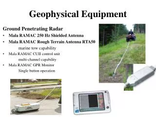
Gravity Recovery and Climate Experiment • GRACE: • launch: March 2002 • altitude: ~450 km • distance: ~250 km • orbitperiod: 94 min • polar orbit JPL
GRACE Observations distance: ca. 250 000 000 000 μm accuracy: 12 digits Comparison: average human hair: 0.05 mm => 50 μm (keep in mind: speed: 27.500 km/h) K-band microwave ranging instrumentaccuracy: < 1 μm GPS receiver: accuracy: 2-3 cm
GRACE results: gravity field Long-termmeangravityfield (differencesofgravitycomparedto ellipsoid) gravity anomalies [mGal]
GRACE results: gravity field Long-termmeangravityfield (differencesofgravitycomparedto ellipsoid) Temporal variations e.g. monthlymodels
GRACE results: gravity field First time observation of temporal gravity field variations on the global scale! New measurement type for hydrology, oceanography, glaciology, geophysics… download GRACE solutions: http://icgem.gfz-potsdam.de/ICGEM/ Temporal variations e.g. monthlymodels
Outline The GRACE mission - observationprinciple Whatarethechallenges? Applications (examples)
Challenges Whycan GRACE databe a littledifficult? GRACE observesthegravityfieldfromfaraway => Downwardcontinuation 1)
Upward/downward continuation Satellitealtitude Gravitational potential in spherical harmonics 6378 km 450 km 6378 + 450 km [mgal] Dampening factors (10.000 km) (160 km) Groundlevel (110 km) [mgal]
Upward/downward continuation Satellitealtitude observation noise c GRACE sees only smoothed version of gravity field [mgal] Amplification of (high frequency) noise dampening of small features (high frequencies) noise Groundlevel [mgal]
Challenges Whycan GRACE databe a littledifficult? GRACE observesthegravityfieldfromfaraway => Downwardcontinuation 1) The gravityfieldchangescontinuously, but ittakes time tocollectthedata => Aliasing 2)
GRACE Ittakes time tocollectsatellitedata, but thegravityfieldchangescontinuously 1 day 15 days 30 days
GRACE Ittakes time tocollectsatellitedata, but thegravityfieldchangescontinuously Short-periodic gravity changes: • tides: • tidal forces (sun, moon, planets) • Earth tides • ocean tides • atmospheric variations and the • reaction of the ocean • pole tides atmospheric variations
GRACE Ittakes time tocollectsatellitedata, but thegravityfieldchangescontinuously Short-periodic gravity changes: • tides: • tidal forces (sun, moon, planets) • Earth tides • ocean tides • atmospheric variations and the • reaction of the ocean • pole tides ocean tides
GRACE Ittakes time tocollectsatellitedata, but thegravityfieldchangescontinuously Short-periodic gravity changes: Models: • tides: • tidal forces (sun, moon, planets) • Earth tides • ocean tides • atmospheric variations and the • reaction of the ocean • pole tides JPL DE405 IERS2003 EOT11a AOD1B OMCT IERS2003 BUT: every model has errors Short-term gravity variations have to be reduced
Aliasing residual signal (after reduction of models) monthly models unmodelled variations Undersampling of the short-term variations => „Aliasing“ This results in …
Monthly solution 2007 - 04 Why north-south stripes? • very high measurement accuracy along-track • sampling along the orbit => gravity field (unmodelled short-periodic effects) might have changed completely between neighboring arcs
Challenges Whycan GRACE databe a littledifficult? GRACE observesthegravityfieldfromfaraway => Downwardcontinuation 1) The gravityfieldchangescontinuously, but ittakes time tocollectthedata => Aliasing 2) Wehaveto do somethingaboutthenoise => Filtering, Leakage 3)
Filtering Gaussian filter 2007 - 04 water height [cm]
Filtering Gaussian filter Filter: 200 km 2007 - 04 water height [cm]
Filtering Gaussian filter Filter: 250 km 2007 - 04 water height [cm]
Filtering Gaussian filter Filter: 300 km 2007 - 04 water height [cm]
Filtering Gaussian filter Filter: 400 km 2007 - 04 water height [cm]
Filtering Gaussian filter Filter: 500 km 2007 - 04 water height [cm] stronger filtering => less noise But: filtering implies spatial averaging also of the signal => „Leakage effect“
Leakage signal (500 km Gauss filter) modelled signal (unfiltered, without noise) stronger filtering => less noise But: filtering implies spatial averaging also of the signal => „Leakage effect“
Leakage river basin average: 4.0 cm/year average: 7.4 cm/year signal (500 km Gauss filter) modelled signal (unfiltered, without noise) stronger filtering => less noise But: filtering implies spatial averaging also of the signal => „Leakage effect“
Leakage Leakage Signal original Region of interest Filter stronger filtering => less noise But: filtering implies spatial averaging also of the signal => „Leakage effect“ Leakage-Out Leakage-In
Leakage Leakage Signal original Region of interest Filter Generally damping of signal in region of interest => underestimation of amplitude => Estimation of re-scaling factor to obtain full signal. (Can be difficult!) Leakage-Out Leakage-In
Challenges Whycan GRACE databe a littledifficult? GRACE observesthegravityfieldfromfaraway => Downwardcontinuation 1) The gravityfieldchangescontinuously, but ittakes time tocollectthedata => Aliasing 2) Wehaveto do somethingaboutthenoise => Filtering, Leakage 3) GRACE observesthe integral masssignal => Loading, Signal separation 4)
Loading GRACE measures gravitational potential => conversion to mass Mass But: GRACE has no depth perception Crust Mantle
Loading massgain GRACE measures gravitational potential => conversion to mass Mass But: GRACE has no depth perception Crust Signal separation of variations at surface and in mantle using loading theory massloss Mantle equivalent water height gravity field coefficients elastic response of the Earth (load love numbers)
Signal Separation Atmosphere Hydrology Ice Ocean • Separation of integral mass signal: • Reduction of unwanted signals • using models • => Model errors included in mass • estimate • statistical / mathematical • approaches (e.g. PCA, ICA) GIA Mantle and Crust
Outline The GRACE mission - observationprinciple Whatarethechallenges? Applications (examples)
GRACE results (ITG-Grace03) Alreadyreduced: tides (ocean, Earth, …), atmosphere & oceanvariations
Trend and amplitude Annual amplitude Trend water height [cm] water height [cm/year]
Annual amplitude water height [cm]
Hydrology 1gt = 1km³ water! Amazon [giga tons]
equator Hydrology 1gt = 1km³ water! Amazon [giga tons] Orinoco
Hydrology GRACE time seriesprovidevaluableinformationto hydrologists WHY? Improvementof global hydrologicalmodels canopy snow soil groundwater global lakes local lakes local wetlands WaterGAP: models water storages and flows on 0.5° x 0.5 ° grid global wetlands river Problems: model physics, insufficient data coverage (e.g. percipitation) (Döll et al 2003)
Hydrology 1gt = 1km³ water! Amazon GRACE [giga tons]
Hydrology 1gt = 1km³ water! Amazon GRACE [giga tons] Underestimationofamplitude in themodel WaterGAP Possible solution: model calibration
Hydrology GRACE WaterGAP WaterGAPcalibrated Underestimationofamplitude in the model! Possible solution: model calibration (Werth et al. 2009)
Trend 47
India GRACE Groundwater withdrawal seems to be detectable by GRACE Rodell et al. (2009), Nature
India Groundwater withdrawal seems to be detectable by GRACE Why is this so important? e.g. altimetry surface waters canopy snow soil groundwater e.g. SMOS For the first time it is possible to observe groundwater changes from space