Download
1 / 40
420 likes | 603 Views
Large scale contour mapping of Bakken production sites. John.Farrell@fidelityepco.com. Company profile. Fidelity Exploration & Production Co. 2013 Headquarters in Denver 800,000 Net Acres 28 Million Barrels Oil Equivalent. Project scope.

E N D
Large scale contour mapping of Bakken production sites John.Farrell@fidelityepco.com
Company profile • Fidelity Exploration & Production Co. 2013 • Headquarters in Denver • 800,000 Net Acres • 28 Million Barrels Oil Equivalent Large Scale Contour Mapping of Bakken Production Sties
Project scope • Use GPS surveying and GIS to map oil & gas production sites operated by Fidelity E&P Co. • 141 sites in Mountrail and Stark Counties, ND • Supplement company portfolio of existing maps for other operating areas • Perform work in-house at low cost • Hire and train (2) interns to perform survey • Conduct survey between 1-June 2014 and 1-Aug 2014 • Post-process and produce maps during Q3/Q4 2014 Large Scale Contour Mapping of Bakken Production Sties
Resources • Project leader • (2) GIS Specialists • (2) GIS/Engineering Interns • (2) Trimble GeoExplorer 6000 XH GPS Receivers • (2) Trimble TerraSync software • Rugged PC for data processing during the survey • (3) Trimble Pathfinder Office software • ArcGIS Desktop – ArcInfo – Spatial Analyst – 3D Analyst software on office PCs • Pickup truck Large Scale Contour Mapping of Bakken Prduction Sties
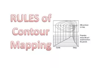
What is a contour map? “A contour line represents the tracing of one constant elevation above or below a certain datum. In other words, every point on any one contour line is at the same elevation throughout that contour line. Although the datum may be an assumed point of elevation accommodating the job, it is more often based upon Mean Sea Level” -Gurdon Wattles, Survey Drafting Large Scale Contour Mapping of Bakken Production Sties
USGS contour map Large Scale Contour Mapping of Bakken Production Sties
Need for contour maps • Storm water drainage and spill prevention plans regulated by North Dakota Department of Health • Storm Water Pollution Prevention Plan (SWPPP) “Provide a site map showing … drainage patterns, including flow direction, dividing lines, existing grade and final grade” • Support Environmental Engineers managing erosion and sediment controls Large Scale Contour Mapping of Bakken Production Sties
Approach • Identify software and devices to use • Establish proper differential correction technique • Verify elevation accuracy of Trimble Geo XH • Develop surveying practice for contour mapping • Create work plan • Deploy field crew • Align system settings with local geodetic control • Maintain data management of collected information • Post-process • Produce maps Large Scale Contour Mapping of Bakken Production Sties
Study area Large Scale Contour Mapping of Bakken Production Sties
Cultivated fields and draws Large Scale Contour Mapping of Bakken Production Sties
Standing water Large Scale Contour Mapping of Bakken Production Sties
Standing water Large Scale Contour Mapping of Bakken Production Sties
Standing water Large Scale Contour Mapping of Bakken Production Sties
Standing water Large Scale Contour Mapping of Bakken Production Sties
Field crew Large Scale Contour Mapping of Bakken Production Sties
Walking a traverse Large Scale Contour Mapping of Bakken Production Sties
Collected data Large Scale Contour Mapping of Bakken Production Sties
Pathfinder Office Export Large Scale Contour Mapping of Bakken Production Sties
ArcMap point features Large Scale Contour Mapping of Bakken Production Sties
ArcMap Create Tin Large Scale Contour Mapping of Bakken Production Sties
ArcMap TIN Large Scale Contour Mapping of Bakken Production Sties
ArcMap Tin to Raster Large Scale Contour Mapping of Bakken Production Sties
ArcMap raster Large Scale Contour Mapping of Bakken Production Sties
ArcMap Raster Symbology Large Scale Contour Mapping of Bakken Production Sties
ArcMap Contour Large Scale Contour Mapping of Bakken Production Sties
ArcMap Contours Large Scale Contour Mapping of Bakken Production Sties
ArcMap Smooth Line Large Scale Contour Mapping of Bakken Production Sties
ArcMap smooth contours Large Scale Contour Mapping of Bakken Production Sties
ArcMap infrastructure map Large Scale Contour Mapping of Bakken Production Sties
Viewpoint #1 Large Scale Contour Mapping of Bakken Production Sties
#1 looking north-northeast Large Scale Contour Mapping of Bakken Production Sties
Viewpoint #1 Large Scale Contour Mapping of Bakken Production Sties
#1 looking south-southeast Large Scale Contour Mapping of Bakken Production Sties
Viewpoint #2 Large Scale Contour Mapping of Bakken Production Sties
#2 looking west Large Scale Contour Mapping of Bakken Production Sties
Viewpoint #3 Large Scale Contour Mapping of Bakken Production Sties
#3 looking north-northwest Large Scale Contour Mapping of Bakken Production Sties
Viewpoint #4 Large Scale Contour Mapping of Bakken Production Sties
#4 looking west Large Scale Contour Mapping of Bakken Production Sties
Contact info John.Farrell@FidelityEPCO.com Large Scale Contour Mapping of Bakken Production Sties