Download
1 / 24
240 likes | 371 Views
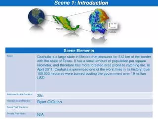
Using the New 3D Base Scene: An Introduction. Brian Sims Christophe Charpentier Craig McCabe. Content is Integral to the Platform. The Heartbeat of the System …. … to Map, Understand and Analyze the World … in the Cloud and On-premises. ArcGIS includes a Living Atlas of the World.

E N D
Using the New 3D Base Scene: An Introduction Brian Sims Christophe Charpentier Craig McCabe
Content is Integral to the Platform The Heartbeat of the System … … to Map, Understand and Analyze the World … in the Cloud and On-premises
ArcGIS includes a Living Atlas of the World Curated Content for Many Topics Maps and Layers from Esri and Thousands of Contributors . . . Providing a Foundation for Your Work Basemaps Boundaries Elevation Hydro Transportation Habitats Hazards Soils Oceans Urban Systems Land Cover Observations Landscape Demographics Imagery Historical Weather Collection is Growing and Changing on a Daily Basis ArcGIS Online: An Introduction to the Living Atlas
Content is published by Esri, Users and Partners Esri Community Partners Local / Regional Industry Specific Foundational Map Layers
Accessing the Living Atlas through ArcGIS Multiple ways to Experience the Living Atlas of the World through ArcGIS Apps ArcGIS Online (ArcGIS.com) Ready-to-Use Maps feature pages Gallery: Esri Featured Content Add Data: Browse Esri Map Layers Living Atlas of the World Web App (New!) Browse and preview maps, layers, and tools Explorer for ArcGIS App (New!) Native App for iOS and Mac platforms Free to use with your Org Subscription ArcGIS Online: An Introduction to the Living Atlas
Join the ArcGIS Content Community http://bit.ly/ContentCommunity ArcGIS Online: An Introduction to the Living Atlas
3D Base Scene Introduction Demo Using the New 3D Basemap: An Introduction
3D Base Scene World Elevation Multi-Component Scene ArcGIS 3D Base Scene Using the New 3D Basemap: An Introduction
3D Base Scene World Elevation Multi-Component Scene • 2D Maps • World Imagery Map • World Topographic Map • Ocean Basemap • Etc. ArcGIS 3D Base Scene Using the New 3D Basemap: An Introduction
3D Base Scene World Elevation Multi-Component Scene • 2D Maps • World Imagery Map • World Topographic Map • Ocean Basemap • Etc. ArcGIS 3D Base Scene • 3D Base Layers • 3D Buildings • 3D Trees • Water Bodies Using the New 3D Basemap: An Introduction
3D Base Scene Multi-Scale Scene Using the New 3D Basemap: An Introduction
3D Base Scene Multi-Scale Scene Using the New 3D Basemap: An Introduction
3D Base Scene Multi-Scale Scene Elevation Buildings Water Bodies Trees New 2D Map Using the New 3D Basemap: An Introduction
3D Base Scene Multi-Scale Scene Evacuation Planning Asset Management Events Locate Space Management Using the New 3D Basemap: An Introduction
3D Base Scene Designed to Support Your Work Operational Layers 3D Cartography • Muted design for Base Scene • Non-Textured Buildings • Support thematic & analytic results • Rules for operational layers City Scale Base Layers Using the New 3D Basemap: An Introduction
3D-Enable Your GIS 3D City Best Practices Available Now: http://bit.ly/esri3dcities Using the New 3D Basemap: An Introduction
3D-Enable Your GIS ArcGIS for Professionals Workflows http://bit.ly/esri3dcities ArcGIS for 3D Cities: An Introduction
Share Your 3D City Engine Web Scene • Share project area 3D scenes • Tie together with 2D web maps • View in browser with no plugin • Host in ArcGIS Online Examples: • Washington DC, USA Building Height Study • Christchurch, New Zealand Redevelopment Story Map Type Presentation Title Here
Share Your 3D Server 10.3 – Scene Services • Share campus to global scale data • Mash up your GIS layers with 3D Base Scene • Host on premises or in ArcGIS Online Type Presentation Title Here
Get Started Now! Start Here: • Create your 3D city base layers http://bit.ly/esri3dcities • 3D-enable your operational layers • Share CityEngine Web Scene At 10.3 Release: • Mash up with 3D Base Scene • Publish Scene Services Type Presentation Title Here
Recommended Sessions • ArcGIS for 3D Cities: An Introduction • Wednesday 8:30am – 9:45am – Room 03 • Thursday 3:15pm – 4:30pm – Room 31C • Friday 9:00am – 10:15am – Room 04 • Extending the 3D Base Scene with Your City • Thursday 9:30am – 10:00am – Demo Theater (Online GIS) • Smart 3D Cities: Top Five 3D Use Cases for Local Governments around the World • Wednesday 2:30pm – 3:00pm – Demo Theater (Mapping & Visualization) • Visit us at the 3D Island in Exhibit Hall Type Presentation Title Here
Join the ArcGIS Content Community http://bit.ly/ContentCommunity ArcGIS Online: An Introduction to the Living Atlas
Thank you… Please fill out the session survey: Offering ID: 746 Online – www.esri.com/ucsessionsurveys Paper – pick up and put in drop box Using the New 3D Basemap: An Introduction