Download
1 / 12
120 likes | 228 Views
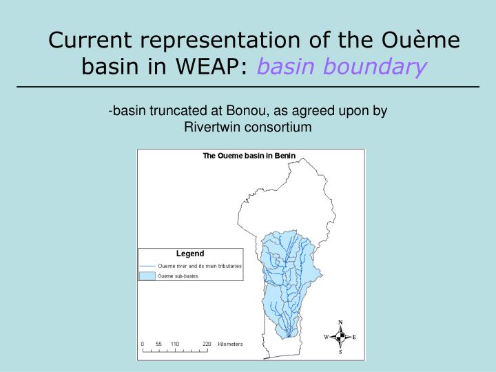
Current representation of the Ouè me basin in WEAP: basin boundary. -basin truncated at Bonou, as agreed upon by Rivertwin consortium. Current representation of the Ouè me basin in WEAP: Sub-basins.

E N D
Current representation of the Ouème basin in WEAP: basin boundary -basin truncated at Bonou, as agreed upon by Rivertwin consortium
Current representation of the Ouème basin in WEAP: Sub-basins -basin divided into 15 sub-basins defined for Rivertwin project (within version truncated at Bonou)
Current representation of the Ouème basin in WEAP: Sub-basins each sub basin is represented by: one catchment node (for hydrology modeling) one domestic/industrial demand node one agriculture demand node one groundwater node
Current representation of the Ouème basin in WEAP: full schematic
Current representation of the Ouème basin in WEAP: domestic/industrial demand one domestic/industrial demand node per sub-basin village populations aggregated by sub-basin Simple water use rate (10 m3/person) obtained from “World’s Water” Demand = sub-basin population x water use rate
Current representation of the Ouème basin in WEAP: agriculture demand one agriculture demand node per sub-basin demand represented on a per capita basis simple water use rate (30 m3/person) obtained from “World’s Water” Demand = sub-basin population x water use rate
Current OuèmeData Structure • Domestic/Industrial Demand on a per-capita basis for each sub-basin • Agricultural Demand on a per-capita basis for each sub-basin • 4 GRDC Gauging Station data Estimates based on World Water values What additional data do we need, what is available, and from where?
Data needed to advance the WEAP model of the Ouème basin basin-wide land use maps (to allow land use-driven hydrologic modeling)
Data needed to advance the WEAP model of the Ouème basin historical climate data (precip, wind, temp, humidity) for each sub-basin to model runoff, baseflow, ET.
Data needed to advance the WEAP model of the Ouème basin streamflow data from the Rivertwin gauges (to allow calibration of the model at various points in the basin). Presently, only have GRDC gauge data (1948-1992)
Data needed to advance the WEAP model of the Ouème basin basin-wide land use maps historical climate data streamflow data from the Rivertwin gauges groundwater use (volumes used by sector, preferably at the sub-basin level) – presently have locations of wells at village level domestic/industrial water use rates, with any sub-basin level and intra-annual variations irrigation water use by crop, with patterns of monthly variation and proportion coming from groundwater versus surface water
Data basin-wide land use maps (Rivertwin Database) historical climate data (CD) streamflow data from the Rivertwin gauges (Exist, accessible) groundwater use (volumes used by sector, preferably at the sub-basin level) – presently have locations of wells at village level ( domestic/industrial water use rates, with any sub-basin level and intra-annual variations irrigation water use by crop, with patterns of monthly variation and proportion coming from groundwater versus surface water