Download
1 / 10
100 likes | 232 Views
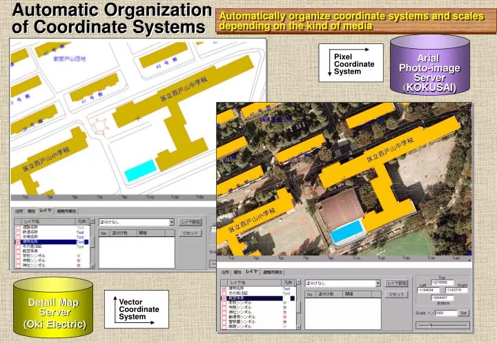
Automatic Organization of Coordinate Systems. Automatically organize coordinate systems and scales depending on the kind of media. Pixel Coordinate System. Arial Photo-image Server ( KOKUSAI). Detail Map Server (Oki Electric). Vector Coordinate System.

E N D
Automatic Organization of Coordinate Systems Automatically organize coordinate systems and scales depending on the kind of media Pixel Coordinate System Arial Photo-image Server (KOKUSAI) Detail Map Server (Oki Electric) Vector Coordinate System
The Open GIS Specification Model Topic 12: The Open GIS Service Architecture Geospatial Coordinate Transformation Services (GCTS) Transform geographic coordinate values from one coordinate system to another
Physical Compensation of Geospatial Object Automatic Compensation of Spatial Object Distortions which happens in composing multiple objects Example of distortions between building-outlines of the residential map and the city planning map They are compensated and symbolized in order to adopt thematic maps. Application DB Server (NEC) Detail Map Server (Oki Electric)
Physical Compensation of Geospatial Object Automatic Compensation of Spatial Object Distortions which happens in composing multiple objects Example of distortions between building outlines of the summarized-map and the thematic map. Summarized map does not hold building-outlines, so their locations are not only compensated but also symbolized. Application DB Server (NEC) Summarized Map Server (PASCO)
The Open GIS Specification Model Topic 12: The Open GIS Service Architecture Feature Analysis Services (FAS) Exploit information available in a Feature or Feature Collection to derive application-oriented quantitative results that are not available from the raw data itself. Composed of 9 operations ①Buffering to create a proximity zone ②Boolean operations to perform binary operations on two or more features ③Determine if any features in the Feature Collection obstruct ④Compute non-stored geometric properties ⑤Exploiting elevation coverages ⑥Create geospatial model of one or more related Feature Collections ⑦Interpret feature properties ⑧Exploiting transportation routes ⑨Computing exposure
The Open GIS Specification Model Topic 12: The Open GIS Service Architecture Geospatial Feature Manipulation Services (GFMS) Support creation, quality control methods, analysis, and display of feature collections of interest to an end user. Composed of 5 operations ①Register one feature to another、an image, or another data set or coordinate set. ②Examines the internal correctness and consistency of features and their properties ③Deconflict features by applying ④Modify a feature and its description ⑤Modify the values of metadata elements (properties) describing a feature
District. Town Tall Road General Road Railroad Water Part Railway Station Buildings Government office Buildings Annotations Semantic Compensation of Geospatial Object Compensate the difference between objects which hold a same name but hold different entities. Compensate difference caused from the M-to-N relationships of objects. Application DB (Disaster Prevention) Legacy DB1 ( Residential Map ) Legacy DB2 ( Summarized Map ) City Bound. Town Bound. Block Road Railroad Water Bound. Buildings City Names Town Names Road Names Railroad Names Water Bound. Names Building Names Annotations Symbol Arial Photo-image Subjects Major Section Bound. Minor Section Bound. Block Bound. 1 Road Railroad Water Bound. 1 Water Bound. 2 Buildings City & Special Area Names Town Names General Building Names Landmark Names Other Strings 1 Symbol Application DB Server (NEC) Summarized Map Server (PASCO) Detail Map Server (Oki Electric)
The Open GIS Specification Model Topic 12: The Open GIS Service Architecture Feature Generalization Services (FGS) Modify the characteristics of a feature collection to increase the effectiveness of communication by counteracting the undesirable effects of data reduction
Trader Service Architecture Step1: Retrieval Demand from Web Terminal Step4: Get Retrieval Result Retrieval Condition ・Search Demand Area ・Display Type (3-Dimensional) ・Base Scale … Step2: Trader Graph Generation Step5: Display Retrieval Result Adding Optimal Real-time Process to the Retrieval Results Step3: Transfer Search Processing Step3: Transfer Search Processing Step3: Transfer Search Processing Distributed & Cooperative Retrieval of Geo-Spatial Objects based on Trader Graph Spatial Information Directory Service Community Merge Processing GSOT Position Correction 3-D Process Scale Conversion GSOT Map Service Community 2-D Map Data Mesh Data 3-D VRML Files GSOT GSOT GSOT Building Information Service Community National Numerical Map Service Community Vector Map Service Community
Process flow of GSM’s active retrieval mechanism (in future) WWW Server GSM Active Retrieval Mechanism Evaluate Terminal Capability Data Blade or Data Cartridge Dispatch Spatial Retrieval Func. Image Conversion Media Conversion ORDBMS Vector Conversion Uniquely managed Spatial and Attribute Data Feature Conversion If the terminal capability is sent to the GSM, it is evaluated and dispatched spatial retrieval functions, then retrieved data is actively converted into various forms by the media conversion function. This mechanism corresponds with various level of portrayal model.