Download
1 / 23
230 likes | 255 Views
Explore NYS landscapes through interaction of erosional & uplifting forces. Identify mountain, plateau, lowland regions & ESRT mapping. Study geographic ages & bedrock geology in Lab #3-9 from pages 123-127.

E N D
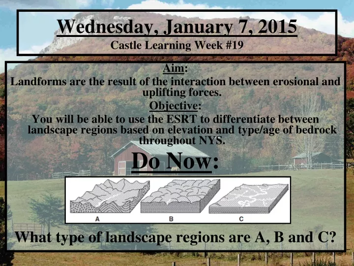
Wednesday, January 7, 2015Castle Learning Week #19 Aim: Landforms are the result of the interaction between erosional and uplifting forces. Objective: You will be able to use the ESRT to differentiate between landscape regions based on elevation and type/age of bedrock throughout NYS. Do Now: What type of landscape regions are A, B and C?
A is a mountain: Note the uplift and contorted layers B is a plateau: High elevation, but flat, level layers C is a lowland: Flood plain, flat, low elevation, meandering stream
Exit Summary: NYS Landscapes • Give a specific NYS location for each type of landscape region and explain the two key factors responsible for identifying each type.
Landscape: Forms from the interaction of erosional and uplifting forces.
Dissected Plateau: An elevated expanse of land broken by a river or canyon.
Stream Drainage Pattern: The path of streams/rivers in a watershed.
Procedure A: Area Elevation High Elevation = Red [Mountains] Middle Elevation = Yellow [Plateaus] Low Elevation = Green [Lowlands/Plain] Color AND label map on page 126 using page 2 of your ESRT as a guide HIGH MEDIUM LOW
Exit Summary: NYS Landscapes • Give a specific NYS location for each type of landscape region and explain the two key factors responsible for identifying each type.
Procedure B: Surface Drainage Systems Trace and label watersheds listed on page 124 on Map 2 on page 126 using page 3 of your ESRT as a guide.
Procedure C: Geographic Ages and Bedrock Geology • Use page 3 of your ESRT to list the age and type of bedrock at each specified location. • For example: High/mountain elevations are: • Age: Middle Proterzoic • Type: Intensely Metamorphic
Age Period/Era Type Sedimentary Metamorphic Intensely Metamorphic