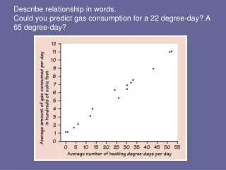
Download
1 / 79
1.09k likes | 2.25k Views
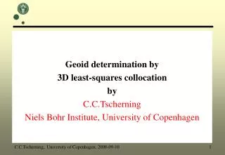
Geoid determination by least-squares collocation using GRAVSOFT. C.C.Tscherning, University of Copenhagen, 2005-01-28 1. Purpose:.

E N D
Geoid determination by least-squares collocation using GRAVSOFT C.C.Tscherning, University of Copenhagen, 2005-01-28 1
Purpose: Guide to gravity field modeling, and especially to geoid determination, using least-squares collocation (LSC). DATA GRAVITY FIELD MODEL EVERYTHING = Height anomalies, gravity anomalies, gravity disturbances, deflections of the vertical, gravity gradients, spherical harmonic coeffients C.C.Tscherning, University of Copenhagen, 2005-01-28 2
Quasi-geoid: Important: the term geoid = the quasi-geoid, i.e. the height anomaly evaluated at the surface of the Earth. C.C.Tscherning, University of Copenhagen, 2005-01-28 3
Gravsoft The use of the GRAVSOFT package of FORTRAN programs will be explained. A general description of the GRAVSOFT programs are given in http://cct.gfy.ku.dk/gravsoft.txt which is updated regularly when changes to the programs have been made. C.C.Tscherning, University of Copenhagen, 2005-01-28 4
FORTRAN 77 • All programs in FORTRAN77. • Have been run on many different computers under many different operating systems. • Available commercially, but free charge if used for scientific purposes. C.C.Tscherning, University of Copenhagen, 2005-01-28 5
General methodology • General methodology for (regional or local) gravity field modelling : • Transform all data to a global geocentric geodetic datum (ITRF99/GRS80/WGS84), (but NO tides, NO atmosphere) GEOCOL • “geoid-heights” must be converted to height anomalies N2ZETA • Use the remove-restore method. C.C.Tscherning, University of Copenhagen, 2005-01-28 6
Remove-restore method • The effect of a spherical harmonic expansion and of the topography is removed from the data and • subsequently added to the result. GEOCOL, TC, • TCGRID • This is used for all gravity modelling methods including LSC. • This will produce what we will call residual data. (Files with suffix *.rd). C.C.Tscherning, University of Copenhagen, 2005-01-28 7
Covariance Determine at statistical model (a covariance function) for the residual data in the region in question. EMPCOV, COVFIT C.C.Tscherning, University of Copenhagen, 2005-01-28 8
Select Make a homogeneous selection of the data to be used for geoid determination using rule-of-thumbs for the required data density, SELECT If many data select those with the smallest error XSelection of points O closest to the middle. 6 points selected X o o o x X o x o o x x C.C.Tscherning, University of Copenhagen, 2005-01-28 9
Errors • check for gross-errors (make histograms and contour map of data), GEOCOL • verify error estimates of data, GEOCOL. C.C.Tscherning, University of Copenhagen, 2005-01-28 10
Gravity field approximation and datum • Determine using LSC a gravity field approximation, including contingent systematic parameters such as height system bias N0. GEOCOL • Compute estimates of the height-anomalies and their errors. GEOCOL • If the error is too large, and more data is available add new data and repeat. C.C.Tscherning, University of Copenhagen, 2005-01-28 11
Restoring and checking. • Check model, by comparison with data not used to obtain the model. GEOCOL. • Restore contribution from Spherical Harmonic model and topography. GEOCOL, TC. • Convert height anomalies to geoid heights if needed N2ZETA. • The whole process can be carried through using the GRAVSOFT programs • Compare with results using other methods ! C.C.Tscherning, University of Copenhagen, 2005-01-28 12
Test Data • GRAVSOFT includes data from New Mexico, USA, which can be used to test the programs and procedures. (Files: nmdtm, nmfa, nmdfv etc.) • They have here been used to illustrate the use of the programs. C.C.Tscherning, University of Copenhagen, 2005-01-28 13
Anomalous potential. • The anomalous gravity potential, T, is equal to the difference between the gravity potential W and the so-called normal potential U, T = W-U. • T is a harmonic function, and may as such be expanded in solid spherical harmonics, Ynm • GM is the product of the gravitational constant and the mass of the Earth and the fuly normalized spherical harmonic coefficients. C.C.Tscherning, University of Copenhagen, 2005-01-28 14
Coordinates used. GEOCOL accepts geocentric, geodetic and Cartesian (X,Y,Z) coordinates but output only in geodetic. C.C.Tscherning, University of Copenhagen, 2005-01-28 15
Solid spherical harmonics. • where a is the semi-major axis and Pnm the Legendre functions. • We have orthogonality: C.C.Tscherning, University of Copenhagen, 2005-01-28 16
Bjerhammar-sphere The functions Ynm(P) are ortho- gonal basefunctions in a Hilbert space with an isotropic inner- product, harmonic down to a so-called Bjerhammar-sphere totally enclosed in the Earth. T will not necessarily be an element of such a space, but may be approximated arbitrarily well with such functions. In spherical approximation the ellipsoid is replaced by a sphere with radius 6371 km. C.C.Tscherning, University of Copenhagen, 2005-01-28 17
Reproducing Kernel where ψis the spherical distance between P and Q, Pn the Legendre polynomials and σn are positive constants, the (potential) degree-variances. P r Q ψ r’ C.C.Tscherning, University of Copenhagen, 2005-01-28 18
Inner product, Reproducing property C.C.Tscherning, University of Copenhagen, 2005-01-28 19
Closed expression – no summation to • the degree-variances are selected equal to simple polynomial functions in the degree n multiplied by exponential expressions like qn, where q < 1, then K(P,Q) given by a closed expression. Example: C.C.Tscherning, University of Copenhagen, 2005-01-28 20
Hilbert Space with Reproducing Kernel • Everything like in an n-dimensional vector space. • COORDINATES: • ANGLES between two • functions, f, g • PROJECTION f ON g: • IDENTITY MAPPING: C.C.Tscherning, University of Copenhagen, 2005-01-28 21
Data and Model In a (RKHS) approximations T from data for which the associated linear functionals are bounded. • The relationship between the data and T are expressed through functionals Li, yi is the i'th data element, Lithe functional, ei the error, Ai a vector of dimension k and X a vector of parameters also of dimension k. C.C.Tscherning, University of Copenhagen, 2005-01-28 22
Data types GEOCOL codes: 11 12 13 16 17 • Also gravity gradients, • along-track or area mean values. C.C.Tscherning, University of Copenhagen, 2005-01-28 23
Test data C.C.Tscherning, University of Copenhagen, 2005-01-28 24
Linear Functionals, spherical approximation C.C.Tscherning, University of Copenhagen, 2005-01-28 25
Best approximation: projection. Ti pre-selected base functions: C.C.Tscherning, University of Copenhagen, 2005-01-28 26
Collocation LSC tell which functions to select if we also require that approximation and observations agree and how to find projection ! Suppose data error-free: We want solution to agree with data We want smooth variation between data C.C.Tscherning, University of Copenhagen, 2005-01-28 27
Projection Approximation to T using error-free data is obtained using that the observations are given by, Li(T) = yi C.C.Tscherning, University of Copenhagen, 2005-01-28 28
LSC - mathematical • The "optimal" solution is the projection on the n-dimensional sub-space spanned by the so-called representers of the linear functionals, Li(K(P,Q)) = K(Li,Q). • The projection is the intersection between the subspace and the subspace which consist of functions which agree exactly with the observations, Li(g)=yi. C.C.Tscherning, University of Copenhagen, 2005-01-28 29
Collocation solution in Hilbert Space Normal Equations Predictions: C.C.Tscherning, University of Copenhagen, 2005-01-28 30
Statistical Collocation Solution We want solution with smallest “error” for all configurations of points which by a rotation around the center of the Earth can be obtained from the original data. And agrees with noise-free data. We want solution to be linear in the observations C.C.Tscherning, University of Copenhagen, 2005-01-28 31
Mean-square error - globally C.C.Tscherning, University of Copenhagen, 2005-01-28 32
Global Covariances: C.C.Tscherning, University of Copenhagen, 2005-01-28 33
Covariance – series development C.C.Tscherning, University of Copenhagen, 2005-01-28 34
Collocation Solution C.C.Tscherning, University of Copenhagen, 2005-01-28 35
Noise • If the data contain noise, then the elements σij of the variance-covariance matrix of the noise-vector is added to K(Li,Lj) = COV(Li(T),Lj(T)). • The solution will then both minimalize the square of the norm of T and the noise variance. • If the noise is zero, the solution will agree exactly with the observations. • This is the reason for the name collocation. • BUT THE METHOD IS ONLY GIVING THE MINIMUM LEAST-SQUARES ERROR IN A GLOBAL SENSE. C.C.Tscherning, University of Copenhagen, 2005-01-28 36
Minimalisation of mean-square error The reproducing kernel must be selected equal to the empirical covariance function, COV(P,Q). This function is equal to a reproducing kernel with the degree-variances equal to C.C.Tscherning, University of Copenhagen, 2005-01-28 37
Covariance Propagation • The covariances are computed using the "law" of covariance propagation, i.e. • COV(Li,Lj) = Li(Lj(COV(P,Q))), • where COV(P,Q) is the basic "potential" covariance function. • COV(P,Q) is an isotropic reproducing kernel harmonic for either P or Q fixed. C.C.Tscherning, University of Copenhagen, 2005-01-28 38
Covariance of gravity anomalies Appy the functionals on K(P,Q)=COV(P,Q) C.C.Tscherning, University of Copenhagen, 2005-01-28 39
Evaluation of covariances The quantities COV(L,L), COV(L,Li) and COV(Li,Lj) may all be evaluated by the sequence of subroutines COVAX, COVBX and COVCX which form a part of the programs GEOCOL and COVFIT. C.C.Tscherning, University of Copenhagen, 2005-01-28 40
Remove-restore (I). If we want to compute height-anomalies from gravity anomalies, we need a global data distribution. If we work in a local area, the information outside the area may be represented by a spherical harmonic model. If we subtract the contribution from such a model, we have to a certain extend taken data outside the area into account. (The contribution to the height anomalies must later be restored=added). C.C.Tscherning, University of Copenhagen, 2005-01-28 41
Change of Covariance Function C.C.Tscherning, University of Copenhagen, 2005-01-28 42
Homogenizing the data • minimum mean square error in a very specific sense: • as the mean over all data-configurations which by a rotation of the Earth's center may be mapped into each other. • Locally, we must make all areas of the Earth look alike. • This is done by removing as much as we know, and later adding it. We obtain a field which is statistically more homogeneous. C.C.Tscherning, University of Copenhagen, 2005-01-28 43
Homogenizing (II) • 1.We remove the contribution Ts from a known spherical harmonic expansion like the OSU91A field, EGM96 or a GRACE model complete to degree N=360 • 2. We remove the effect of the local topography, TM, using Residual Terrain Modelling (RTM): Earths total mass not changed, • but center of mass may have changed !!! • We will then be left with a residual field, with a smoothness in terms of standard deviation of gravity anomalies between 50 % and 25 % less than the original standard deviation. C.C.Tscherning, University of Copenhagen, 2005-01-28 44
Residual quantities C.C.Tscherning, University of Copenhagen, 2005-01-28 45
Exercise 1. • Compute residual gravity anomalies and deflections of the vertical using the OSU91A spherical harmonic expansion and the New Mexico DTM, cf. Table 1. The free-air gravity anomalies are shown in http://cct.gfy.ku.dk/geoidschool/nmfa.pdf • The program GEOCOL may be used to subtract the contribution from OSU91A. • Job-files: http://cct.gfy.ku.dk/geoidschool/jobosu91.nmfa • http://cct.gfy.ku.dk/geoidschool/jobosu91.nmdfv C.C.Tscherning, University of Copenhagen, 2005-01-28 46
Output-files Output from run: http://cct.gfy.ku.dk/geoidschool/appendix2.txt OSU91: http://cct.gfy.ku.dk/geoidschool/osu91a1f Differences: http://cct.gfy.ku.dk/geoidschool/nmfa.osu91 http://cct.gfy.ku.dk/geoidschool/nmdfv.osu91 Difference map: http://cct.gfy.ku.dk/geoidschool/nmfaosu91.pdf C.C.Tscherning, University of Copenhagen, 2005-01-28 47
Residual topography removal The RTM contribution may be computed and subtracted using the program tc1. • First a reference terrain model must be constructed using the program TCGRID with the file nmdtm as basis, http://cct.gfy.ku.dk/geoidschool/nmdtm • A jobfile to run tc1 • http://cct.gfy.ku.dk/geoidschool/jobtc.nmfa • The result should be stored in files with names nmfa.rd and nmdfv.rd, respectively. • The residual gravity anomalies • http://cct.gfy.ku.dk/geoidschool/nmfard.pdf C.C.Tscherning, University of Copenhagen, 2005-01-28 48
Smoothing or Homogenisation C.C.Tscherning, University of Copenhagen, 2005-01-28 49
Consequences for the statistical model. • The degree-variances will be changed up to the maximal degree, N, sometimes up to a smaller value, if the series is not agreeing well with the local data (i.e. if no data in the area were used when the series were determined). • The first of N new degree-variances will depend on the error of the coefficients of the series. We will here suppose that the degree-variances at least are proportional to the so-called error-degree-variances, C.C.Tscherning, University of Copenhagen, 2005-01-28 50