Download
1 / 9
90 likes | 173 Views
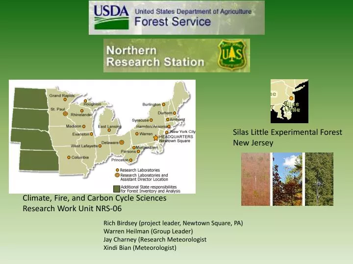
Silas Little Experimental Forest New Jersey. Climate, Fire, and Carbon Cycle Sciences Research Work Unit NRS-06. Rich Birdsey (project leader, Newtown Square, PA) Warren Heilman (Group Leader) Jay Charney (Research Meteorologist Xindi Bian (Meteorologist).

E N D
Silas Little Experimental Forest New Jersey Climate, Fire, and Carbon Cycle Sciences Research Work Unit NRS-06 Rich Birdsey (project leader, Newtown Square, PA) Warren Heilman (Group Leader) Jay Charney (Research Meteorologist Xindi Bian (Meteorologist)
Evaluation of Computational Methods for the Low Elevation Haines Index. Potential Future Changes in the Atmospheric Component of Fire Risk. Haines Index Climatology using the North American Regional Reanalysis
A modular modeling system that enables fire information, consumption, and smoke modeling. Lesley Fusina, Sharon Zhong. Jay Charney and Xindi Bian Evaluate model predictions of smoke using observational data from the October 2007 Southern California Wildfire outbreaks. The results indicate that while smoke models can currently predict smoke trajectories, the timing of smoke impacts and predictions of ground concentrations need improvement.
Impacts of Land Management on the Climate System Research Participants Principal Investigator Warren E. Heilman, Research Meteorologist, US Forest Service Northern Research Station David Hollinger, Plant Physiologist, US Forest Service Northern Research Station Ken Clark, Research Forester, US Forest Service Northern Research Station Xindi Bian, US Forest Service Northern Research Station Richard Birdsey, Project Leader, US Forest Service Northern Research Station Yude Pan, Research Forester, US Forest Service Northern Research Station Research Partners Sharon Zhong, Atmospheric Scientist, Michigan State University Xiuping Li, Visiting Scientist, Michigan State University
Development of Modeling Tools for Predicting Smoke Dispersion from Low-Intensity Fires Principal Investigator: Warren E. Heilman OSU RAFLES Model
Original Experimental Design NJ Pine Barrens N Pine overstory, Vaccinium with Oak understory 265 Acres Ambient measurements 1 km NW of burn site Wind Direction Plow lines (Ignitions along lines from south to north) 30 m Tower 10 m Tower PM2.5 Monitor 20 m Tower 3 m Tower SODAR
JSFP RAWS project Jay Charney Sharon Zhong Mike Kiefer Investigating the differences between the gridded meteorological fields produced by the Real Time Mesoscale Analysis (RTMA) and observed meteorological conditions at Remote Automated Weather Stations (RAWS) in the northeastern United States. The differences will be analyzed and tools developed to improve the interpretation of NWS fire weather forecasts and clarify their role in fire management decision making.