Download
1 / 43
440 likes | 891 Views
Weather, Adiabatic Processes, and Storms!. Weather. Air Masses Atmospheric Condition Atmospheric Lifting Mechanisms Thunderstorms! Violent stuff... Tornados, lightning, MCCs, oh my!. Air Masses.

E N D
Weather • Air Masses • Atmospheric Condition • Atmospheric Lifting Mechanisms • Thunderstorms! • Violent stuff... • Tornados, lightning, MCCs, oh my!
Air Masses • Introduction: Examine movie of Global Water (watervapor.mov) Vapor(invisible water in the atmosphere as a gas) • See air masses of little and lots water vapor with definite geographic boundaries • Air Mass: extensive volume of the atmosphere having essentially uniform temperature and humidity conditions • Air masses horizontally similar for thousands of square kilometers; distinct from adjacent volumes of the atmosphere • Originate where atmosphere has high pressure allowing the air to “absorb” the temperature and humidity characteristics of the surface
Air Mass Climatology • First lettter: m=maritine c=continental • Second letter P=polar T=tropical A=arctic E=Equatorial • Which drier & hotter: mP or cT • Which more humid: mT or cA • Focus on North America weather; Examples: • The Southwest monsoon = switch in wind flow – from a cT to mT • Eastern US summer is humid when the mT air mass from the Gulf of Mexico dominates (NAmMoistureFlow.mov) • Bitter cold in Eastern USA when cA air mass dives south • World Air Masses: general idea is that amount of water vapor decreases as get colder (higher latitude) • Why?
Atmospheric Conditions • Stable Air: resists vertical movement; only moves if force is applied • Unstable Air: Rises without external force or will continue to rise after force is removed • Conditional Stability: occurs when air parcel is between absolute stability and absolute instability • Acts like stable air until external force is applied • When forced to rise, may become unstable if condensation occurs
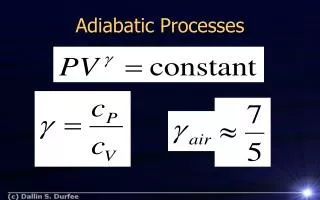
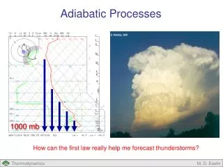
Atmospheric Condition • Is the Atmosphere Stable or Unstable? • Never ending supply of people who don't study: InstabilityLeno.movInstabilityJester.mov • Adiabatic Processes • Key Fact: Large masses of air can be cooled to the dew point ONLY by expanding as they rise • Due to this limitation, adiabatic cooling is the only prominent mechanism for development of clouds and production of rain
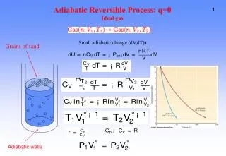
Adiabatic Processes • Temperature change occurs without gain or loss of heat; air cools when rise; warms when sinks and compresses • (great animation: AdiabaticProcesses.MOV gives the basic story) • More slowly: Just changes from potential to kinetic energy
Lapse Rates(can get complicated... we'll keep it simple) • DALR - dry adiabatic lapse rate: rate at which a parcel of unsaturated air cool as it rises • Relatively steady: 10 C°/1000 m or 5.5 F°/1000 ft • WALR - wet (saturated/moist) adiabatic lapse rate • Variable: 2-3°F/1000 ft; 3-6°C/1000m • Occurs at Lifting Condensation Level • Where cooling to dew point forces rate changes because of release of latent heat • ELR - environmental lapse rate • Global average 3.5°F/1000 ft; 6.4°C/1000m • THIS CHANGES along the atmospheric profile
Stability & Instability • Stability: if forced to rise, air returns to original position • Temperature Inversions are extremely stable • Instability: if air forced to rise, continues to rise • Mountains often most unstable air: cold air aloft • Dust devils can form when extreme surface heating (but LCL not reached)
Making Clouds • Ever wonder why clouds have flat bases? • See Lifting Condensation Level clearly • Orographic (mountain) effect influences precipitation patterns • Orographic (mountain) effect influences winds • Lifting one air mass over another • Convergence (vs. divergence) at the surface
Other Important Aspects • Air flow over mountain range and lee winds (Rocky Mtn: Chinook; Alps: Foehn – FoehnWind.mov) • Rainshadows: Why? (Movie: CloudDissipate.mov) • Rainshadows: Where? • Grand Canyon Descending Air... • Hawaiian Islands in trades • Olympic Rainshadow; Cascade Mtns Rainshadow; Sierra Nevada rainshadow • Himalayan Rainshadow…Seen from Space Station
Other Important Aspects • Inversions and Air Pollution • General Condition - inverse of the "normal" temperature decrease with elevation • Traps Pollutants - because little "vertical" mixing • Inversions prevent vertical mixing, so the air pollution moves horizontally; worst where mountains prevent horizontal dispersion (e.g., Palm Springs area) • Life can be fair: the pollution we create stays close to us • Not just LA: Salt Lake City, Denver • And elsewhere because we drive: Adriatic & China too!!
Atmospheric Lifting Mechanisms • Convectional Lifting • Unequal heating of air surface areas warms one parcel of air, but not the air around it • Orographic Lifting • Topographic barriers force air to ascend upslope • Convergent Lifting • Converging of air parcels and the crowding forces uplift; least common form • Frontal Lifting • A place of atmospheric discontinuity • A narrow zone that is the contact between two air masses that differ in temp., press., humidity, wind, and clouds • Results in either a Cold Front or Warm Front
Frontal Lifting • Cold Front • The leading edge of a cool air mass actively displacing a warm air mass • Cold air forces warm air aloft • 400 km wide (250 mi) • Warm Front • The leading edge of an advancing warm air mass • Warm air moves up and over cold air • 1000 km wide (600 mi)
Thunderstorms! • Stages: Cumulus, Mature, Dissipating • Walnut Gulch (So AZ): TStormWalnutGulch.movFlorida Satellite: TStormsFlorida.mpg • Ingredients: Every thunderstorm needs two ingredients: • Moisture - to form clouds and rain Unstable air - relatively warm air that can rise rapidly (or Lift from fronts, sea breezes, and mountains are capable of lifting air to form thunderstorms) • Updraft Cumulus Stage...pronounced vertical uplift • Warm moist air lifted adiabatically and condenses to form cumulus-type cloud formations • Formation of towering cumulus begins • Little or no precipitation occurs during this stage • Occasional lightning during this stage
Thunderstorms! • Mature stage... • Both updrafts and downdrafts • Downdrafts are air pulled downward by precipitation. Normally downdrafts near the leading edge of the thunderstorm cell, creating a gust front • Most likely time for hail, heavy rain, frequent lightning, strong winds and tornadoes. Lasts an average of 10 to 20 minutes but may last much longer in some storms • Dissipating stage...rain cooled air flows out of the thunderstorms • Rainfall decreases in intensity • Some thunderstorms produce a burst of strong winds during this stage • Lightning remains a danger during this stage
Geography of Thunderstorms • Where? When? • At the ITCZ and tropics in late afternoon • Eastern US warm season...most likely during the late afternoon and evening hours in plains and eastern US • Kicked off by a “cold front” • Fall and spring set off by fronts (animation: TStormAnimation.mov) anytime • In desert areas, over mountains and very "spotty" from place to place • Lightning map shows where you are in danger
Dangerous Thunderstorm Features • Haboob • Air descending out of thunderstorm will often hit the ground and be forced out ahead of approaching storm creating a gust front • A specialty in desert regions (from my porch in AZ: Haboob-pre.avi (7:15pm); Haboob-insitu.avi (7:18pm); Haboob-post.avi 8:25pm), picked up by Hollywood (HidalgoDustStorm.mov)
Dangerous Thunderstorm Features • Downburst: Localized pockets of intense downdrafts can create severe weather conditions • Strong downdraft induces an outward burst (DownburstFormation.mov) of damaging winds on or near the surface. As the colder air strikes the Earth's surface, it begins to “roll” - like water as a boat moves through it • “Rolling air” is compressed causing winds to increase dramatically. • Can be "macroburst" (2.5 miles or large outflow diameter and damaging winds lasting 5 to 30 minutes) • Can be "microburst" (less than 2.5 miles outflow diameter with peak winds lasting only 2 to 15 minutes)
Dangerous Thunderstorm Features • Downbursts • Not tornadoes! Air flows OUT (and usually in a straight line) – not IN, like a tornado: • Damaging winds – as high as 134 in macroburst and 168 mph in microburst • Can hear loud “roaring” sound when wind 75+mph • Can uproot trees, but you'll see damage all going in the same direction • National statistics even more against it being a tornado (for every 1 tornado, 10 downburst damage reports)
Hail • Common in plains • Nightmare for insurance adjusters (HailDestroyingCar.mpg) • How hail forms: with each trip above and below the freezing level our frozen droplet adds another layer of ice... much like the rings in a tree... • Water droplet is picked up by updrafts...carried well above the freezing level and water droplet freezes • Then falls in cold downdrafts...outside thaws and coalesces with smaller water droplets • Then picked up by another updraft...carrying it back into very cold air and re-freezing it • Different sizes of hail: Pea (1/4 inch) Marble (1/2 inch) Dime (3/4 inch) Quarter (1 inch) Golfball Size (1-3/4 inch), Orange sized, Baseball (Grapefruit) Size (2.75 inch), Nebraska's record!
Tornados • The most violent atmospheric phenomenon on the planet; Winds of 200-300 mph occur with the most violent tornadoes (examples: TornadoSamples.mov) – often deadly • Basics: defined as violently rotating (seen rotating from air) columns (KillerTornadoesMay03.mov) of air extending from a thunderstorms to ground • Sometimes associated with mammatus clouds as a precursor • A vortex (TornadoLikeVacuum.mov) • The recipe is simple...
Tornados • Location: Tornadoes are found most frequently in the United States east of the Rocky Mountains – this area has major clashes of cold and warm air masses • Oklahoma has the highest average number of tornadoes with 47 each year…So folks come to Oklahoma to chase • Tornado Alley: TornadoAlley.mov; TornadoAlley.avi • Most dangerous in outbreaks • But can occur west of the rockies (e.g. Salt Lake: TornadoSaltLake.mov) • Can occur all over the eastern US • Can occur over water called water spouts
Tornados • Timing: • Peak in the southern US is March through May, with second peak in the fall – time of major clash of contrasting air masses • But can occur anytime of year • Most commonly between 3pm and 9pm, but can occur anytime • How can you be safest? • Must get cover from flying objects • NOT under a bridge or overpass!
Lightning! • Most commonly occurs in thunderstorms and a common hazard • Process: Opposite charges attract, so the positive and negative charges are pulled toward each other... • The first, invisible stroke is called a stepped leader and the travelling spark • Negative and positive parts of the stepped leader connect, forming... • A conductive path from the cloud to the ground and... • The negative charges rush down it, causing... • The visible stroke
Lightning! • Sequence: • Before • Begging to be Hit • The Loser • Just because idiots didn't get hit doesn't mean they weren't stupid...
Lightning! • Deaths: lightning causes an average of 93 deaths and 300 injuries in the United States each year • Kills occur everywhere: • At ball games • Playing golf, family reunions, using the ATM • Campgrounds, while jogging, standing around • Walking along the beach, while on the water • At a rodeo, on motorcycles, in cars, houses, prison • But don't worry if you find a dead body
Thunder! Caused by the extreme heat associated with the lightning flash (HowThunderForms.mov) • In less than a second, air is heated between 15,000 to 60,000 degrees • Air at this temperature expands rapidly • When lightning strikes very close by, the sound will be a loud bang, crack or snap • The duration of the thunder associated with a nearby lightning strike will be very short • Lightning striking farther away will rumble for a longer period of time as the sound arrives at different times • Due to the length of the lightning flash (typically many miles long)
Thunder! “Flash to Bang” • You can estimate the distance to a thunderstorm using the “Flash to Bang” • Time from seeing lightning until your hear thunder • Counting the seconds between the lightning “flash” and the “bang” of thunder • Sound travels at about 330 m/s • Hence, thunder travels about 1 km in 3 seconds (1 mile per 5 seconds) If flash bang is 10 sec, how far away is the storm?
Mesoscale Convection Complexes • MCCs represent groups of thunderstorms, identified by satellite imagery, as covering 100,000 square kilometers • MCCs often last for 6-12 h • Especially known for producing heavy amounts of rain in the early morning hours • Severe winds, hail, and tornadoes can also occur during the early phases of MCC evolution • Movie shows development: MCCLifeCycle.mpg • Happens often along the Front Range” • Front Range development...