Download
1 / 12
130 likes | 319 Views
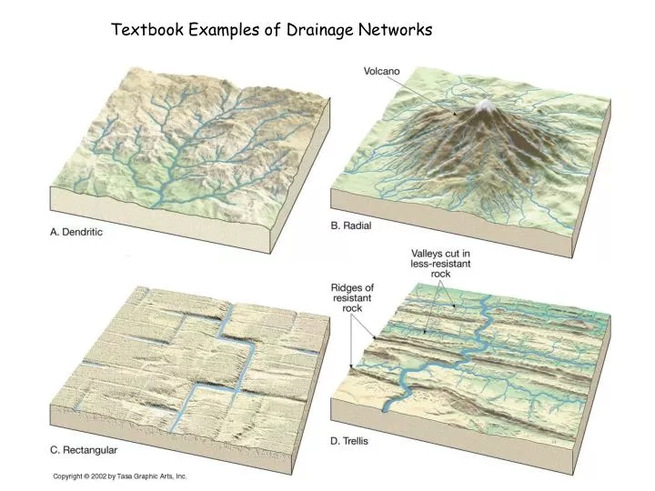
Textbook Examples of Drainage Networks. Digital Elevation Model (DEM). Depressionless DEM. No sinks are present if the Flow Direction tool returns a layer with the 8 principal directions. Sink. Flow Accumulation. Stream Order. Fill. Yes. Flow Direction. Are there any sinks?. No.

E N D
Digital Elevation Model (DEM) Depressionless DEM No sinks are present if the Flow Direction tool returns a layer with the 8 principal directions Sink Flow Accumulation Stream Order Fill Yes Flow Direction Are there any sinks? No The “Input Surface Raster” for the Fill tool is the original DEM Delimit the drainage network using the Raster Calculator. Using a threshold value of 100 limits the drainage network to cells in which the flow accumulation value is 100 cells or greater. drainagenet1 = setnull ([flow accumulation file] < 100, 1)
Output Flow Direction Raster from 2nd Pass using the filled DEM. Note that the symbology indicates that it is a classified surface with values representing the D8 directions, 1, 2, 4, 8,16, 32, 64, 128. Output Flow Direction Raster from 1st Pass using the original DEM. Note that the symbology indicates that it is a continuous, or stretched, surface with values ranging from 1 to 196. This is typical of a surface with sinks.
False Color Image of Northern Part of Franklin, WV Quadrangle
Mount Ranier, WA http://visibleearth.nasa.gov/view_rec.php?id=17316