Download
1 / 1
110 likes | 534 Views
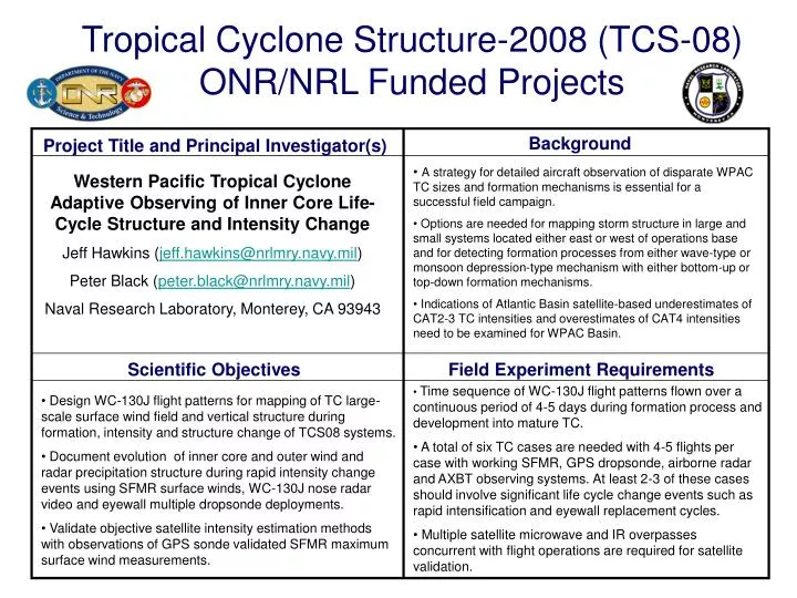
Background. Project Title and Principal Investigator(s). Scientific Objectives. Field Experiment Requirements. Tropical Cyclone Structure-2008 (TCS-08) ONR/NRL Funded Projects.

E N D
Background Project Title and Principal Investigator(s) Scientific Objectives Field Experiment Requirements Tropical Cyclone Structure-2008 (TCS-08)ONR/NRL Funded Projects • A strategy for detailed aircraft observation of disparate WPAC TC sizes and formation mechanisms is essential for a successful field campaign. • Options are needed for mapping storm structure in large and small systems located either east or west of operations base and for detecting formation processes from either wave-type or monsoon depression-type mechanism with either bottom-up or top-down formation mechanisms. • Indications of Atlantic Basin satellite-based underestimates of CAT2-3 TC intensities and overestimates of CAT4 intensities need to be examined for WPAC Basin. Western Pacific Tropical Cyclone Adaptive Observing of Inner Core Life-Cycle Structure and Intensity Change Jeff Hawkins (jeff.hawkins@nrlmry.navy.mil) Peter Black (peter.black@nrlmry.navy.mil) Naval Research Laboratory, Monterey, CA 93943 • Time sequence of WC-130J flight patterns flown over a continuous period of 4-5 days during formation process and development into mature TC. • A total of six TC cases are needed with 4-5 flights per case with working SFMR, GPS dropsonde, airborne radar and AXBT observing systems. At least 2-3 of these cases should involve significant life cycle change events such as rapid intensification and eyewall replacement cycles. • Multiple satellite microwave and IR overpasses concurrent with flight operations are required for satellite validation. • Design WC-130J flight patterns for mapping of TC large-scale surface wind field and vertical structure during formation, intensity and structure change of TCS08 systems. • Document evolution of inner core and outer wind and radar precipitation structure during rapid intensity change events using SFMR surface winds, WC-130J nose radar video and eyewall multiple dropsonde deployments. • Validate objective satellite intensity estimation methods with observations of GPS sonde validated SFMR maximum surface wind measurements.