Download
1 / 17
180 likes | 192 Views
Join the HiRISE Challenge to analyze Mars images for signs of water. Study terrains, interact with scientists, and unlock Mars' mysteries. Explore possibilities beyond Earth!

E N D
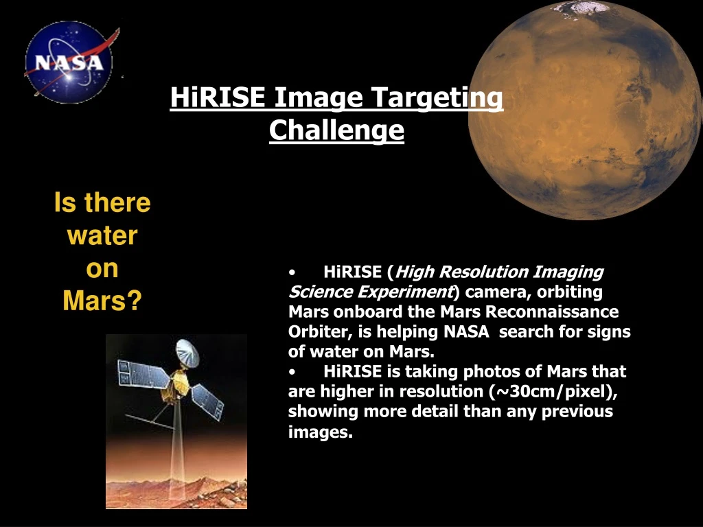
HiRISE Image Targeting Challenge Is there water on Mars? • HiRISE (High Resolution Imaging Science Experiment) camera, orbiting Mars onboard the Mars Reconnaissance Orbiter, is helping NASA search for signs of water on Mars. • HiRISE is taking photos of Mars that are higher in resolution (~30cm/pixel), showing more detail than any previous images.
Objectives: • Help choose some regions of Mars for HiRISE to image that probably contained water at the surface in the past. • Learn more about Mars terrains • Study the pictures in order to write image captions and analysis reports • Encourage students to have a critical view • Interact with real life scientists (web casts and web chats were organized)
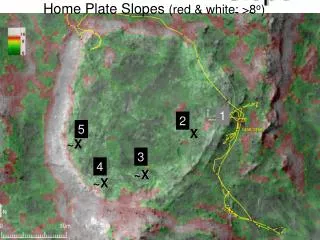
1st project: 1. Name of teacher/student or class group: Mrs. Stoica’s 9th D class of “Tudor Vianu” National High School of Computer Science, Bucharest, Romania. 2. What HiRISE image did you choose to study? The image we chose is PSP_007961_2530 (Center Lat, Lon °E: 72.90, 162.01). In the picture we observe a major crater, a small mountain chain, sand dunes and a series of valleys.
3. Describe the area that has been imaged by HiRISE. What features in the images provide clues to the type of setting? Why might this be a good general area to look for evidence of water? The image we chose represents part of a valley which is part of a mountain chain. We may compare sections of the image with empty river banks from Earth, located in isolated zones, that preserved the exact sedimentary structures through time, with images from the Martian surface. Although we know there is a huge difference in pressure (about 0.8kPa compared to Earth’s pressure of 101.3kPa) and temperature (from 186K (-87ْ C) to 268k (-5 ْC)) and in biological factors(the absence of fauna and flora) we hope that the water course would be quite the same. We should also consider the gravitational acceleration which is different on Mars, 3.69 m/s², while on Earth it’s 9.8 m/s².
4. Compare the HiRISE image at its lowest resolution with it’s highest zoom level. Discuss what additional information zooming in to the HiRISE image tells you about this location. What can we see at highest zoom level that we couldn’t see at the lowest zoom level? Yes, we can observe similarities between Earth’s Map and the HiRISE images of Mars. In both cases we see canyons, valleys, mountains and small craters (only some visible on Earth) that may hold signs of existing water on the surface of the Red Planet. As we presented at the previous question we compared the empty river banks from Earth, located in isolated zones, which preserved the exact sedimentary structures through time, with images from the Martian surface. When in 50% zoom mode we can observe details that could indicate water existence, microforms such as – valleys, small craters, ravines and small deposits of possible ice. We can also study the texture of the ground. Some textures indicate the gathering of sediments which can lead to possible existence of rivers, lakes, etc. All of these are clues in finding areas that could have previously been covered by water or micro forms of life (extremophiles). When we zoom all the way to full mode we observe ground roughness which may be a clue in finding water deposits. The surface dunes could be used to approximate winds and other climate elements which would help us in comparing river banks from Earth (with similar climate conditions as on the Martian surface) with, hopefully, dried river marks. Rocks can indicate the flow of the water and the existence of estuaries, which have bigger rock concentration. Also we can observe crevasses which may sustain traces of ice. In the plain areas we can see dunes, similar to the flat zones on Earth, that may have been created by winds or other weather phenomena. If we found water, we should search for extremophiles (endolith or cryptoendolith) similar to those populating fissures or aquifers on Earth.
5. What observations or clues in the HiRISE images and their context lead you to think there may or may not have been water at this location in the past? Why are they important and what can they tell you? We think that water may have existed on Mars as a conclusion to our studies of images, at all scales: from high to low resolution. Images are the main source of research. They can show us structures, such as mountains, valleys, canyons and volcanoes and even smaller geographical features: crevasses and small valleys which can still hold ice. If we find water on Mars this would be a revolutionary discovery because it could mean the existence of forms of life on other planets and it may mean the beginning of space colonization.
5. Draw conclusions from your work. What have you learned? As a conclusion to our studies of images at all scales - from high to low resolution - we think that water may have existed on Mars. Images are the main source of research. They can show us structures, such as mountains, valleys, canyons and volcanoes and even smaller geographical features: crevasses and small valleys which can still hold ice. We gained useful information in geology and geography that will help us in the future. Also we improved our team skills and our ability to confront our hypothesis. 6. What new questions came up from working on this project? How would you go about trying to answer these questions? We thought about the existence of water on Mars and furthermore about the existence of life on other planets, even if in the form of extremophiles, microorganisms. We tried to analyze the HiRISE images and we gave our best to answer these questions.
7. May we have your permission to post information in this report on our website? If you have suggested an image, may we have your permission to post the teacher’s name, class, school, location (town, state, country)? If we post your suggestion or use material from this report, how would you like your group cited? We would be honored if you would publish our material and images on your website. Our image is suggested by the team of the 9th D class, “Tudor Vianu” High-School of Computer Science, Bucharest, Romania as part of the HiRISE Quest Fall 2007 Student challenge. 8. Thank you very much for participating in our first HiRISE Quest Student Challenge. So that we may improve future HiRISE Quest Student Challenges, could you please take a few minutes to tell us what you liked about this challenge? What areas need improvement? Any other suggestions or comments? We were honored to participate at the HiRISE Quest Spring 2008 project. We developed a great team spirit and gained knowledge in the characteristics of planet Mars. We were very well informed about the project through your e-mails. We think it’s great that such a wide public has access at a high-resolution map of Mars and that they can study the existence of water on Mars. We hope we can participate at a similar project soon because we really enjoyed working besides you.
1. Name of class group:Mrs. Moraru’s 10th F class of “Tudor Vianu” National High School of Computer Science, Bucharest, Romania. 2nd project: 2. What HiRISE image did you choose to study?We have chosen to study the image PSP_007825_1700.
3. Describe the area that has been imaged by HiRISE. What features in the images provide clues to the type of setting? Why might this be a good general area to look for evidence of water?This part of Mars is described by the coordinates Center Lat, Lon °E: -9.99, 291.31, which shows the north-eastern location, above the equatorial line. The image we have chosen it is located in the Coprates Chasma, a long and deep valley. We believe this might be a good general area to look for evidences of water, because of the position (meteor attacks are fewer in the northern part due to the dense protective atmospheric layer). If we study the image using the zoomable Mars map we notice there are ice marks at the bottom of the valley.
4. Compare the HiRISE image at its lowest resolution (lowest zoom level) with it’s highest zoom level. What can we see at highest zoom level that we couldn’t see at the lowest zoom level? Comparing the zoomed in and zoomed out image we discover important facts. For instance, the zoomed out image gives us a clear point about the position and a full view of the valley. On the other hand, the zoomed in one shows us the structure of the terrain (which varies, and there for this could have been accumulated in time) and the ice marks that are easily recognized at the bottom of the valley. 5. What observations or clues in the HiRISE images and their context lead you to think there may or may not have been water at this location in the past? Why are they important and what can they tell you? Some clues we came up with are related to the structure of the soil, with possible water marks, that can be spotted in the image. The altitude differences of the landscape reveals the different sediment layers which might have been deposited by water source.
7. What new questions came up from working on this project? Supposing there was no water on Mars, another question rises: what could have been the cause of the formation of the deep and narrow valley ? Other question: are these the marks of a former sea or a river ? 6. Draw conclusions from your work. What have you learned? We have learned to analyze as a group each detail of the image, closely looking for marks of water. Each team member expressed his opinion and we have realized how important each suggestion was. We compared this region with other former water flows on Earth.
9. Any other suggestions or comments? We like the fact that we are the first ones to see a close up of Mars and that the project was based on team work and learn new things about the Universe and our planet, by comparing it with Mars. 8. May we have your permission to post information in this report on our website? Yes, you have our permission to post all our information.
Polygon Network and Scalloped Depressions in Western Utopia Planitia (PSP_010034_2250) Credit: NASA/JPL/University of Arizona Impact Crater amid the Deuteronilus Mensae (PSP_009654_2245)Credit: NASA/JPL/University of Arizona Gypsum-Rich Dunes in Olympia Undae (PSP_010071_2615)Credit: NASA/JPL/University of Arizona Structure of the North Polar Layered Deposits (PSP_010008_2630)Credit: NASA/JPL/University of Arizona
Here are several questions from the web chat: • Horia_CNITV <Q> Is it true that some snowfalls have been spotted on Mars?Virginia_Gulick<A>Yes, the Phoenix lander has a laser onboard that is designed to gather knowledge about how the atmosphere and surface interact and has detected snow about 2-3 miles above the surface. • Horia_CNITV <Q> What about water in the Martian atmosphere? Is there any? How can we explain the snowfalls the Phoenix Observer has spotted?Alexandra_Davatzes<A>There is very little water in the thin Martian atmosphere, which is mostly made up of carbon dioxide. CO2 forms ice as well, especially at the cold temperatures and low pressures on Mars. CO2 ice forms on the polar caps each winter. • Victor_CNITV <Q> And what about the height of the Martian atmosphere?Virginia_Gulick<A>Well like Earth's atmosphere, Mars' atmosphere is densest in the lowest places and thinnest in the highest reaches. The height of the atmosphere is somewhat higher thanthe Earth's. The scale of Mars atmosphere is roughly about 11km in height.
Victor_CNITV <Q>Well if it is mostly CO2 that means that the presence of water will make vegetal life posible, no?Virginia_Gulick<A>Well people have thought of that before. There is a whole field of study known as Terraforming. The short answer is that it would take a very long time for plants to be able to survive. The atmosphere is very very thin (meaning not very dense) • Luca_CNITV <Q> Considering mars temperature, in what state could we find water on Mars, on the surface or in the ground?Alexandra_Davatzes<A>We know there is water ice on the surface and just beneath the surface on Mars right now. It is possible that highly saline (salty) water could also be stable, but that has not yet been found. The ice on Mars tends to sublimate directly from a solid (ice) to a gas. • Luca_CNITV<Q> On what criteria did NASA scientists choose the landing place of the Phoenix?Virginia_Gulick<A> They wanted to land near the polar layer deposits in hope of sampling ice. They had to pick a site that had the least hazards to the lander. • Luca_CNITV<Q> Is it possible to find other resources on Mars such as fossil fuel?Virginia_Gulick<A>It may be possible to find other resources such as mineral resources. Water would also be considered a resource if we could find it near enough to the surface.
Impressions • We liked the fact that we had access to high resolution images of Mars. This activity gave us the opportunity to improve our knowledge about Martian terrains and structure. • It was a fun way to develop out team work abilities and gain useful information. This was the first NASA project we were involved in and it propelled us towards other interesting activities. We are proud to continue the tradition and participate for the 3rd time at this project. • For more information about the HiRISE project: http://quest.nasa.gov/challenges/hirise/