Download
1 / 17
170 likes | 184 Views
Learn about digitizing maps, using GPS, and understanding the relationship between raster and vector encoding for accurate location mapping. Explore methods like GPS satellite positioning and differential corrections.

E N D
Chapter 9Map Digitizing and GPS For the book Mapping in the Cloud Guilford Press Michael P. Peterson
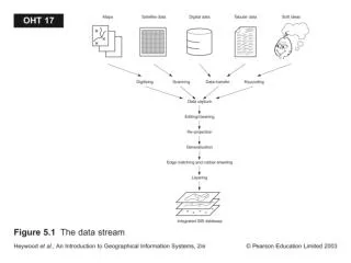
Raster to Vector Conversion
Relationship between Cartesian and spherical coordinates
GPS satellite
Handheld GPS receiver