Download
1 / 30
330 likes | 591 Views
Surveying and Digitizing. Primary Data Sources. Measurements Field → surveying Lab (not covered here) Remotely sensed data already secondary? Creating geometries Definitely in the realm of secondary data Digitizing Scanning. Surveying. Measurements and measurement techniques

E N D
Primary Data Sources • Measurements • Field → surveying • Lab (not covered here) • Remotely sensed data • already secondary? • Creating geometries • Definitely in the realm of secondary data • Digitizing • Scanning
Surveying • Measurements and measurement techniques • Distances • Angles • Position determination • Applications • Traversing and mapping • Construction and earthwork • Boundary surveys
Definition of Surveying • General • To inspect, view, scrutinize, or examine • To determine condition, situation, or value • Specifically • Science and art of determining relative positions of points above, on, or beneath earth surface
Uses of Surveying • Locate/map resources • Engineering design • Layout construction or engineering projects • Verify performance • Acquire reliable data • Provide control • Usually for location
History of Surveying • Early applications • Boundary location • Construction • Mapping • Early surveys limited by technology • Crude and inconsistent methods • Development of sighting devices, standards, …
History of Surveying (2) • Industrial revolution improved surveying • Advances in available materials • Improvement in tools • Electronics revolution fundamental advances • Electronic distance and angle measurement • Satellite surveying • Enhanced processing
Specific Types of Surveying • Property (cadastral) surveying • Control surveying • Mapping surveying (planimetric or topographic) • Photogrammetric surveying • Construction (engineering) surveying • Route surveying • Hydrographic surveying
Surveying Measurements • Two quantities measured in surveying • Lengths • Angles • All measurements are imperfect • Errors • Mistakes
Measurement Errors • Sources of errors • Natural • Instrumental • Types of errors • Systematic • Random • Terms used in describing errors • Precision • Accuracy • Personal
Idea of Relative Position • Question: Have the points moved? • Answer: Relative to what? • References • Needed for expressing location of points, lines, other objects • Datums provide references in surveying • Horizontally • Vertically
f = flattening e = eccentricity Reference Ellipsoids Basic Concept a = semi-major axis b = semi-minor axis
Example Reference Ellipsoids GRS = Geodetic Reference System WGS = World Geodetic System ITRS = International Terrestrial Reference System
Ignoring Earth Curvature • Distance ( 5 miles .006m 8000 + 0.25”) 8000.000m ( 5 miles) 1000 km 998.95 km
Ignoring Earth Curvature (2) • Level line Horizontal plane 1 mile (1609 m) 8 inches ( 20 cm) Level surface
Ignoring Earth Curvature (3) • Triangle geometry Sum of Interior Angles = 180° 00' 01" 75 mi2(48,000 acres)19,800 hectares
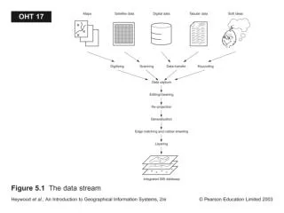
Digitizing and Scanning • Instruments • Georeferencing • The process and problems associated with it • Automation • Formats
Why Do We Have To Digitize? • Existing data sets are general purpose, so if you want something specific you have to create it • In spite of 20+ years of GIS, most stuff is still in analog form • Chances are somebody else has digitized it before; but data sharing is not what it should be
Digitizer • Digitizing table10” x 10” to 80” x 60”$50 - $2,0001/100th inch accuracy • Stylus or puck with control buttons
The Digitizing Procedure • Affixing the map to the digitizer • Registering the map • Actual digitizing • In point mode • In stream mode
Georeferencing • at least 3 control pointsaka reference points or tics • easily identifiable on the map • exact coordinates need to be known
Digitizing Modes • Point mode • most common • selective choice of points digitized • requires judgment • for man-made features • Stream mode • large number of (redundant) points • requires concentration • For natural (irregular) features
Problems With Digitizing • Paper instability • Humidity-induced shrinking of 2%-3% • Cartographic distortion, aka displacement • Overshoots, gaps, and spikes • Curve sampling
Errors From Digitizing • Fatigue • Map complexity • ½ hour to 3 days for a single map sheet • Sliver polygons • Wrongly placed labels
Digitizing Costs • Rule of thumb: one boundary per minuteergo:appr. 62 lines= more than one hour
Automated Data Input (Scanning) • Work like a photocopier or fax machine • Three types: • Flatbed scanners • A4 or A3 • 600 to 2400 dpi optical resolution • $50 to $2,000 • Drum scanner • practically unlimited paper size • $10k TO $50k • Video line scanner • producesvector data
Requirements for Scanning • Data capture is fast but preparation is tedious • Computers cannot distinguish smudges • Lines should be at least 0.1 of a mm wide • Text and preferably color separation • AI techniques don’t work (yet?) • Symbols such as are too variable for automatic detection and interpretation
Semi-automatic Data Input(Heads-up Digitizing) • Reasonable compromise between traditional digitizing and scanning • Much less tedious • Incorporating your intelligence
Criteria for Choosing Input Mode • Images without easily detectable line work should be left in raster format • Really dense line work should be left as background image – • unless it is really needed for automatic GIS analysis; in which case you would have to bite the bullet
Conversion from Other Databases • Autocad .dxf and dBASE .dbf are de facto standards for GIS data exchange • In the raster domain there is no equivalent; .tif comes closest to a “standard” • In any case: merging data that originate from different scales is problematic – in the best of all worlds; there is no automatic generalization routine