Download
1 / 15
150 likes | 159 Views
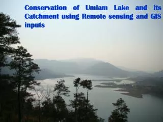
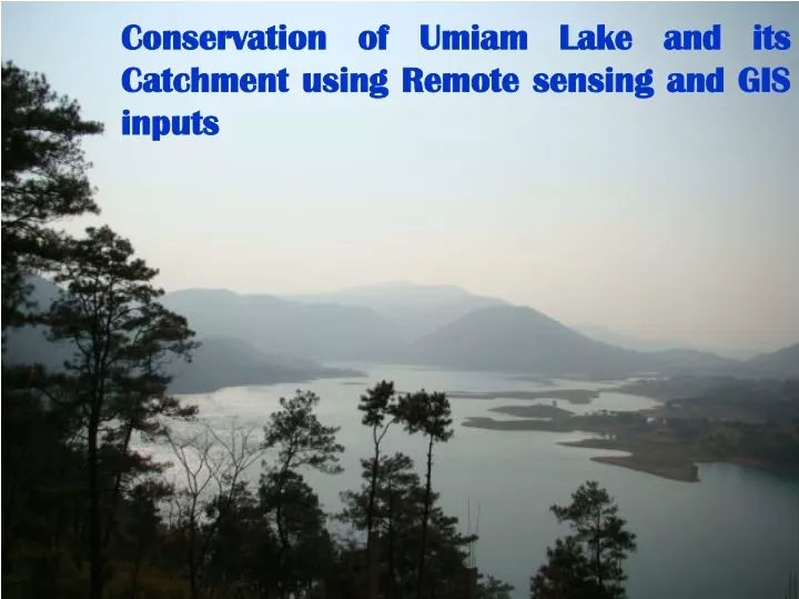
This study focuses on the conservation of Umiam Lake and its catchment in Meghalaya, North East Region. It utilizes remote sensing and GIS inputs to analyze the sub-watersheds, land use, and slope in order to formulate a comprehensive conservation plan.

E N D
Conservation of Umiam Lake and its Catchment using Remote sensing and GIS inputs
STUDYAREA 91º 52’E 91º 54’E 91º 45’E 91º 55’E 25º40’N 25º40’N 25º40’N 25º40’N 25º 38’N 25º 38’N 25º 30’N 25º 30’N 91º 45’E 91º 55’E 91º 52’E 91º 54’E Meghalaya North East Region Umiam catchment Umiam reservoir and its surrounding
SUB-WATERSHED MAP OF UMIAM CATCHMENT U13 U1 U12 U11 U10 U9 U2 U3 U8 U7 U4 U6 U5 91º 45’E 91º 50’E 91º 55’E N 25º40’N 25º40’N 25º 35’N 25º 35’N Water body Sub-watersheds U1 - U13 SCALE 25º 30’N 25º 30’N meter 91º 45’E 91º 50’E 91º 55’E
LANDUSE / LAND COVER MAP OF UMIAM CATCHMENT 91º 55’E 91º 45’E 91º 50’E N 25º40’N 25º40’N Pine dense forest Pine medium denseforest Pine low dense forest Mixed dense forest Mixed medium dense forest 25º 35’N 25º 35’N Mixed low dense forest Agriculture/ current jhum Abandoned jhum Grass/Scrub Gravel stony waste 25º 30’N 25º 30’N Settlement Water body Scale meter 91º 45’E 91º 50’E 91º 55’E
DIGITAL SLOPE MAP OF UMIAM CATCHMENT 91º 50’E 91º 55’E 91º 45’E N 25º40’N 25º40’N 0-3% 3-5% 5-10% 10-15 % 25º 35’N 25º 35’N 15-25 % 25-33 % 33-50 % >50 % Water body 25º 30’N Built up area 25º 30’N 91º 55’E 91º 45’E 91º 50’E Scale meter 91º 45’E 91º 50’E 91º 55’E
APPROACHES IN FORMULATING A CONSERVATION PLAN • Referring to the area available at different slopes and land uses a Conservation Plan was formulated for optimum utilization of soil and water resources to sustain productivity of agricultural and forest lands in the following approaches: • To control soil loss by means by insitu moisture conservation • and runoff management programs such as vegetative hedges, various check dams, contour trenching, contour bunding etc. • 2) To adopt scientific methods of crop production to try and achieve self-sufficiency of food items within the area. • 3) To improve degraded lands by covering underAgro-forestry, Horticulture (including indigenous temperate fruit species), cash crop plantations (Tea etc.) and creating protective aforestation etc.
PRIORITY SUB-WATERSHEDS OF UMIAM CATCHMENT 91º 45’E 91º 50’E 91º 55’E N 25º40’N 25º40’N N LEGEND Very low Low Medium. 25º 35’N 25º 35’N High. Very high Water body 25º 30’N 25º 30’N Scale meter 91º 45’E 91º 50’E 91º 55’E
Land use class(Area in ha) 2005 2008
MAJOR PROBLEMS • Shifting cultivation in the form of ‘Bun’, is one of the major problems plaguing the area, inducing severe erosion and reducing the life span of the reservoir • Improper management of Urban waste results in the accelerated siltation of the reservoir • Regular forest fires destroy all cover and intensify the soil erosion and siltation problems
Problems of Umiam Catchment Area Fire ravaged young pines Barren forest floor after a forest fire Uncontrolled quarrying leading to siltation. Urban waste being washed into the reservoir