Download
1 / 1
10 likes | 233 Views
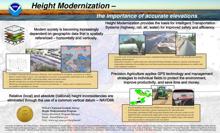
Height Modernization – the importance of accurate elevations. Accurate water levels referenced to accurate, standardized land elevations enable safe and efficient maritime shipping and navigation

E N D
Height Modernization – the importance of accurate elevations • Accurate water levels referenced to accurate, standardized land elevations enable safe and efficient maritime shipping and navigation • Integration of surface weather and water with road elevations benefits commerce, tourism, and emergency preparedness (planning) by providing near real-time monitoring and positioning information on weather and road conditions (response) • Terrain modeling derived from GPS/Remote Sensing data results in more accurate field boundaries and slope (contour) management for land utilization • Geographic information (GIS) integrating planting and yield rates results in well-defined fertilizer and pesticide application saving resources and reducing run-off • GPS controlled precise steering of farm equipment available today, with remotely operating machinery anticipated in the near future Height Modernization provides the basis for Intelligent Transportation Systems (highway, rail, air, water) for improved safety and efficiency. Modern society is becoming increasingly dependent on geographic data that is spatially referenced – horizontally and vertically. Precision Agriculture applies GPS technology and management strategies to individual fields to protect the environment, improve productivity, and save time and money. • In FEMA’s National Flood Insurance Program, risk is measured by elevations, so accuracy is critical • Denser control reduces survey costs and improves accuracy of geospatially related data such as LIDAR, photogrammetry, GIS, RTK, construction plans, and evacuation routes • Benefits include more accurate floodplain and insurance rate maps • Monitoring and management of water resources (groundwater vs. surface water) is improved in areas susceptible to subsidence or erosion Relative (local) and absolute (national) height inconsistencies are eliminated through the use of a common vertical datum -- NAVD88. NOAA’s National Geodetic Survey Height Modernization Program Juliana Blackwell, Program Manager Email: htmod@noaa.gov Visit: www.ngs.noaa.gov/heightmod/ University of California, San Diego/Scripps • Wisconsin Department of Transportation • Harris-Galveston Coastal Subsidence District • California Spatial Reference Center • North Carolina Geodetic Survey • South Carolina Geodetic Survey • NOAA’s National Ocean Service Federal Emergency Management Agency • Louisiana Spatial Reference Center • NOAA’s National Weather Service • Spatial Reference Center of Washington • U.S. Army Corps of Engineers • Washington Department of Natural Resources • Alabama Department of Revenue Louisiana State University • NOAA’s Coastal Services Center • U.S. Geological Survey • Alabama Department of Transportation • North Carolina A & T State University • University of Southern Mississippi • NOAA’s Center for Operational Oceanographic Products & Services