Download
1 / 35
350 likes | 362 Views
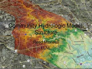
This project aims to develop a hydrologic model for a given area in the Wichita Falls District by delineating the watershed, obtaining and preparing data, and calibrating the model. The objective is to create an accurate model for TxDOT highway drainage structures.

E N D
Development of a Hydrologic Model for the Wichita Falls District Tanya Hoogerwerf
Develop a Hydrologic Model for a TxDOT Highway Drainage Structure (Initial Objective) OBJECTIVE • Develop a Hydrologic Model for a Given Area in the Wichita Falls District (Current Objective)
WICHITA FALLS TxDOT district formed by nine counties: Archer, Baylor, Clay, Cooke, Montague, Throckmorton, Wichita, Willbarger and Young
PROCEDURE Watershed Delineation using ArcView, Spatial Analyst and CRWR-PrePro • Obtaining and Preparing Data for Analysis using ArcView, Spatial Analyst and CRWR-Raster • Preparing a Basin Model for use in the Hydrologic Modeling System (HEC-HMS) • Calibrating the Hydrologic Model
OBTAINING THE NECESSARY DATA • Cataloging Unit • Digital Elevation Models • NHD Data • USGS Flow Gauging Locations and Data
CATALOGING UNIT 1,012,07 sq mi, 919.7 River Miles www.epa.gov/surf2/hucs/
DIGITAL ELEVATION MODEL • CRWR Database, but can also be downloaded from the USGS NED website • Three 1o x 1o seamless version, made up of 30m x 30m cells
NHD DATA • Can be downloaded from the USGS National Hydrography Dataset Website http://nhd.usgs.gov
USGS FLOW GAGING STATIONS • USGS Web Site www.usgs.gov • Only 2 Stations in HUC 11130206
CREATING A POINT COVERAGE OF FLOW GAGING STATIONS • Data from 1/1/97 to 1/1/98 • Defined a table containing ID and lat/long data • Loaded defgages.ave as provided by GIS homework
DATA PREPARATION • Project all data into TSMS Albers • Buffer the Cataloging Unit • Extend and Edit the route.rch • Merge the DEMs • Clip DEM to buffered cataloging unit
PROJECTION PARAMETERS • Texas Standard Mapping System • True earth area preserved in map projections
BUFFERING THE CATALOGING UNIT This can be accomplished using the Theme/Create Buffers Command
EXTENDING THE REACH This can be done with the ArcView editing command…
WATERSHED DELINEATION CRWR-PrePro along with ArcView and Spatial Analyst can process a DEM and delineate its streams and networks
CRWR-PREPRO • Developed at CRWR by Dr. Maidment’s GIS research group • An ArcView preprocessor, currently only for HEC-HMS • http://www.ce.utexas.edu/prof/olivera/prepro/prepro.htm • prepro03a.apr
BURNING IN THE STREAMS AND FILLING THE SINKS (ELEVATION RISE OF 1000 M)
32 64 128 16 1 8 4 2 8-DIRECTION POUR-POINT MODEL
DEFINING A THRESHOLD (Segments may also be added using the Add Streams function) 10,000! 5,000! 1,000!
STREAM LINKS AND LINK OUTLETS • This gives each link its own ID • Outlets are the most downstream cells of the reach segments
ADDING FLOW GAGE POINT COVERAGE Manually define the outlets with the O tool
TWO STEPS TO FINISH UP.... • Preparing a Basin Model for use in the Hydrologic Modeling System (HEC-HMS) • Calibrating the Hydrologic Model …..I have had a few minor problems…..
CRWR 2nd Year StudentsDavid AndersonDr.Olivera SPECIAL THANKS
REFERENCES Delineating the Watershed and Stream Network of the Guadalupe Basin by David Maidment. Developed for the CE394-K3 GIS in Water Resources class at the University of Texas. Fall 1998. Developing a Hydrologic Model of the Guadalupe Basin by Francisco Olivera and David Maidment. Developed for the CE394-K3 GIS in Water Resources class at the University of Texas. Fall 1998. http://www.crwr.utexas.edu/gis/gishyd98/class/trmproj/ahrens/prepro.htm GIS-Based System of Hydrologic and Hydraulic Applications for Highway Engineering by Dr. Olivera and Dr. Maidment.