Download
1 / 12
120 likes | 236 Views
Where the Research Meets the Road: Climate Science, Uncertainties, and Knowledge Gaps. Dennis P. Lettenmaier Department of Civil and Environmental Engineering University of Washington.

E N D
Where the Research Meets the Road: Climate Science, Uncertainties, and Knowledge Gaps Dennis P. Lettenmaier Department of Civil and Environmental Engineering University of Washington First National Expert and Stakeholder Workshop on Water Infrastructure Sustainability and Adaptation to Climate Change Arlington, VA January 6, 2009
Issues in estimating (and planning for) climate change impacts • Design and management of most water-related infrastructure is based on methods of assessing risk and reliability (e.g., flood plain delineation based on 100-year event; water system planning for 98 percent reliability) • These methods are almost entirely based on analysis of historic observations (e.g., fitting a flood frequency distribution to an annual flood maximum series) • These methods often are standardized (e.g., Water Resources Council Bulletin 17b for estimation of flood risk) • Similarly standardized methods are not available when the stationarity of historic observations cannot be assumed
What methods are at our disposal for design and planning in a changing climate? • Global climate models provide our best information as to future realizations (time series) of climate • These is a scale mismatch (spatial, and perhaps temporal) that needs to be bridged for water resources applications (simple ratio or difference methods, statistical, dynamical) • There are considerable differences among GCMs, and these differences need to be incorporated in planning as a representation of uncertainty in the climate prediction process • Each GCM “scenario” is effectively an ensemble member from a particular model (multiple ensemble members from a given GCM provide a measure of another source of uncertainty, natural variability – this type of uncertainty exists in a stationary world as well) • Multimodel ensemble approaches are well adapted to the risk and uncertainty analysis required for water planning – these methods are increasingly used in numerical weather prediction. One complication is that lack of forecast verification opportunities in the climate prediction case. • The assessment process involves a modeling chain, starting with GCM ensemble members
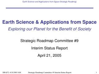
Climate Scenarios Performance Measures Downscaling Global climate simulations, next ~100 yrs Delta Precip, Temp Reliability of System Objectives Reservoir Model Hydrologic Model (VIC) DamReleases, Regulated Streamflow Natural Streamflow
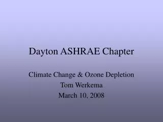
40 Amazon Amur Mackenzie 30 20 10 0 -10 -20 -30 -40 40 Mekong Mississippi Severnaya Dvina 30 20 Change in precipitation (%) 10 0 -10 -20 -30 -40 40 Xi Yellow Yenisei 30 20 10 0 -10 -20 -30 -40 0 1 2 3 4 5 6 7 8 0 1 2 3 4 5 6 7 8 0 1 2 3 4 5 6 7 8 9 Change in temperature (C) GFDL_CGCM HCCPR-CM2 HCCPR-CM3 MPI-ECHAM4 CCCMA-CGCM1 CCSR-CGCM CSIRO-CGCM DOE-PCM3 2025 2045 2095 GCM Predicted Climate Change Change in precipitation and temperature for selected basins
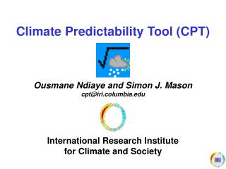
BAU 3-run average historical (1950-99) control (2000-2048) PCM Business-as-Usual scenarios Columbia River Basin (Basin Averages)
Some issues: Bias is a key issue, which must be addressed in any assessment protocol All GCMs are not “created equal” – evaluations using current climate demonstrates this Some GCMs perform better than others (in current climate simulations), but these differences vary both geographically, and depending on evaluation criteria How much effort should be allocated to generation of multiple ensemble members for a given GCM, vs representation of the largest possible number of GCMs (essentially comes down to the role of inter-model uncertainty, vs natural variability) How to downscale? How can we best extract information for water infrastructure design and planning from GCMs?
In general, statistical downscaling offers our best current hope of integrating multimodel ensemble methods into water infrastructure planning and management, based on computational issues alone Scale mismatch between the relevant spatial scale at which design and planning analyses must be performed (e.g., for estimating of reservoir inflows) and the GCM scale is not itself a justification for dynamic downscaling Where there are key processes that affect hydrologic forcings (especially precipitation) that are subgrid to the GCM, dynamical downscaling may be necessary (example: urban stormwater design) Bias correction is an essential step whether or not dynamical downscaling is used. There is also a a question as to whether statistical downcaling methods are required rather than the so-called delta method – one justification for the more complex statistical methods is transient, vs “time slice”, analyses Downscaling issues
Regional climate models: The role of spatial scale Visual from NCAR
Standardization of methods that lead to reproducibility of results (a la Bulletin 17b) – very climate change study cannot be a research project Standard archive data sets of climate model output, updated periodically (IPCC archive has gone a long ways towards meeting this requirement) A recognition of (and methods for dealing with) the fact that climate change projections will be subject to change, albeit periodically Movement away from critical period planning (analysis of the worst period in a sequence of historical observations – e.g., the worst drought) What needs to be done to incorporate climate change into water planning in a routine manner?
Need to better understand the elements of uncertainty inherent in GCM ensemble members (is it possible to represent inter-model uncertainty using resampling from a single GCM)? Better archiving (and retrieval) of GCM output (especially daily and shorter time scale output) Need for a more systematic approach to regional climate simulation and downscaling (mostly computer time and archiving!) A stronger push for applied research and development in water resources, with specific emphasis on hydrologic change (see ASCE JWRPM, Nov-Dec 2008) What are the applications research needs?