Download
1 / 19
190 likes | 379 Views
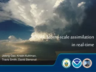
Real-time Storm-scale Forecast Support for IHOP 2002 at CAPS. Ming Xue 1,2 , Keith Brewster 1 , Dan Weber 1 Kevin Thomas 1 , Fanyou Kong 1 , Eric Kemp 1 mxue@ou.edu Center for Analysis and Prediction of Storms (CAPS) 1 School of Meteorology 2 University of Oklahoma.

E N D
Real-time Storm-scale Forecast Support for IHOP 2002 at CAPS Ming Xue1,2, Keith Brewster1, Dan Weber1Kevin Thomas1, Fanyou Kong1, Eric Kemp1mxue@ou.edu Center for Analysis and Prediction of Storms (CAPS)1School of Meteorology2 University of Oklahoma
IHOP_2002 (International H2O Project 2002) • A field experiment that occurred over the Central Great Plain between 5/13 – 6/25/2002 • Science Objectives and Components • Quantitative Precipitation Forecast (QPF) • Convection Initiation (CI) • Boundary Layer (ABL) Processes • Water Vapor Instrumentation and Data Assimilation Research
IHOP Related Research at CAPS • CAPS is supported through an NSF grant to • Contribute to the IHOP field experiment and • Perform research using data collected • Emphases of our work include • Optimal Assimilation of and the • Qualitative assessment of the impact of • Water vapor and other high-resolution observations on storm-scale QPF.
Goals of CAPS Realtime Foreacst • To provide additional high-res NWP support for the real time operations of IHOP • To obtain an initial assessment of numerical model performance • To identify specific data sets and cases for extensive retropective studies
CAPS Real Time Forecast Domain 183×163 273×195 213×131
Model Configuration • ARPS 5.0 of CAPS was used with following options: • Nonhydrostatic dynamics with vertically-stretched terrain-following grid • Domain 20 km deep with 53 levels. First level 10m AGL. • 4th-order advection, simple positive definite scheme for water and TKE. • 3 ice-phase microphysics (Lin-Tao) • New Kain-Fritsch cumulus parameterization on 27 and 9 km grids • NCSA Long and Short Wave Radiative Transfer scheme • 1.5-order TKE-based subgrid scale turbulence closure and PBL Parameterization • 2-layer soil and vegetation model
Data and Initial Conditions • Initial conditions produced by ARPS Data Analysis System (ADAS) with cloud / diabatic initialization • Eta forecast for BC of CONUS grid and first guess for IC analysis • Rawinsonde and wind profiler data: Used on CONUS and SPmeso grids • MDCRS (aircraft observations): All grids. • METAR (surface observations): All grids. • Oklahoma, Western TX and ARM Mesonets: All grids • Satellite: IR cloud-top temperature used in cloud analysis. • CRAFT Level-II and NIDS WSR-88D data: Reflectivity used in cloud analysis on SPmeso and SPstorm grids, and radial velocity used to adjust the wind fields.
Cloud Analysis in the Initial Conditions • Windband Level-II data from 12 radars (via CRAFT) and Level-III (NIDS) data from 12 others in the CGP were used in a cloud analysis procedure that analyzes qv, T and microphysical variables • The cloud analysis also used visible and infrared channel data from GOES-8 satellite and surface observations of clouds
Computational Issues • The data ingest, preprocessing, analysis and boundary condition preparation as well as post-processing were done on local workstations. • The three morning forecasts were made on a PSC HP/Compaq Alpha-based clusters using 240 processors. • The 00 UTC SPstorm forecast was run on NCSA’s Intel Itanium-based Linux cluster, also using 240 processors. • Perl-based ARPScntl system used to control everything • Both NCSA and PSC systems were very new at the time. Considerable system-wide tuning was still necessary to achieve good throughput. A factor of 2 overall speedup was achieved during the period. • Data I/O was the biggest bottleneck. Local data processing was another.
Dissemination of Forecast Products • Graphical products, including fields and sounding animations, were generated and posted on the web as the hourly model outputs became available. • A workstation dedicated to displaying forecast products was placed at the IHOP operation center. • A CAPS scientist was on duty daily to evaluate and assist in the interpretation of the forecast products. • A web-based evaluation form was used to provide an archive of forecast evaluations and other related information. • The forecast products are available at http://ihop.caps.ou.edu, and we will keep the products online to facilitate retrospective studies.
Example: Animation of Page Precipitation Rate at 1 hour intervals
May 12, 2002 ARPS 9 km Forecast – Precip rate NCEP Hourly Precip 12 Hour forecast valid at 00 UTC
May 17, 2002 ARPS 9 km Forecast – Comp. Ref. NCEP Hourly Precip Initial Condition at 12 UTC
June 15, 2002 NCEP Hourly Precip ARPS 3 km Forecast – Comp. Ref. 11 hour forecast valid at 02 UTC
Future Work (where real fun starts) • Multi-scale QPF Verification under way • Simulation Studies of Selected Cases • IC and BC Sensitivity Studies using the Forecast Model and its Adjoint • Continuous Data Assimilation Studies (including radar and GPS data) using 3DVAR and later 4DVAR • Study of Data Impact • Studies of Physical Processes using Model Data Sets