Download
1 / 31
310 likes | 325 Views
Comprehensive briefing on the Draft Bicycle and Pedestrian Plan for the National Capital Region, highlighting existing facilities, key projects, safety data, and regional trends.

E N D
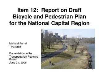
Draft Bicycle and Pedestrian Plan for the National Capital Region Briefing to the TPB Technical Committee April 7, 2006 Item 8 Item 8, April 7, 2006 TPB Technical Committee Michael Farrell COG/TPB Staff
Background • TPB Vision calls for a Bicycle and Pedestrian Plan • Created under the guidance of the Bicycle and Pedestrian Subcommittee of the TPB Technical Committee • Successor to the 1995 regional Bicycle Plan and the 2001 Priorities 2000: Metropolitan Washington Greenways and Circulation Systems reports • Will be advisory to the CLRP, not financially constrained • Intended to be a resource for planners and the public
The Draft Bicycle and Pedestrian Plan: An Overview • Planning Context: • TPB Vision • Federal, State Policies • Local plans • Trends • Mode share • Safety • Existing Facilities for Bicycling and Walking • List of Funded and Unfunded Bicycle and Pedestrian Projects identified by TPB Members • On-line database • Best Practices
Planning Context • TPB Vision, adopted in 1998, calls for: • Convenient, safe bicycle and pedestrian access • Increased walk and bike mode share • Incorporation of pedestrian and bicycle facilities in transportation projects • Walkable regional activity centers and urban core • 2001 Greenways and Circulation Systems reports identify specific projects that support the TPB Vision for walking and bicycling • Federal and State Policies • USDOT Guidance (2000) – “Routine Accommodation” • VDOT Policy (2003) - “Routine Accommodation” • SAFETEA-LU (2005) • Safe Routes to School • Funding eligibility • ADA
Planning Context • CLRP and TIP Bicycle and Pedestrian (B/P) Projects • The 2005 CLRP identifies $147 million in B/P projects (See Appendix C) • The 2006-2011 TIP identifies $122 million in B/P projects (See Appendix D) • Many B/P projects are subsumed within larger transportation projects • Local Plans - Most jurisdictions and agencies have: • A bicycle or pedestrian plan • Selected local plan projects are incorporated into the regional plan • One or more part or full-time bicycle, pedestrian, or trails planners • Priority Unfunded Regional Projects • The B/P Subcommittee periodically identifies a short list of high priority, unfunded B/P projects • The B/P Plan will provide the new context for future lists
Regional Priority Unfunded Bicycle and Pedestrian Projects Bicycle and Pedestrian Projects in State, Local, & Agency Plans and Programs Priorities 2000 Priority Projects TIP Bike/Ped Project List CLRP Bike/Ped Project List Bicycle and Pedestrian Plan Project List Relationship Between Bicycle and Pedestrian Plan, the CLRP, and the TIP
TPB Involvement inEncouraging Bicycling and Walking in the Region • Commuter Connections: Bike to Work Day • 5,000 participants • 20 “pit stops” • Friday, May 19. Register at www.waba.org • Bike to Work Guide • A publication for employers and employees • ADC Regional Bike Map • Guaranteed Ride Home
Trends for Walking and Bicycling • Nationally, 10% of all trips are made on foot or by bike • The Washington region has a pedestrian and bicycle commute mode share of 3.4%, compared to a national average of 3.31% • Bicycling and Walking are most common • In neighborhoods near downtown D.C. • Near selected metro stations • Near college campuses • Near major trails • On military bases • The following maps and charts show walk and bike commute data from the 2000 Census
Walk and Bike to Transit • Walking is the dominant mode of access to transit. • 83% bus • 61% Metrorail • Varies by station (See Appendix G) • Biking to transit is less common • 0.31% access Metrorail by bike • Most common near college campuses and major bike trails (See Appendix H) • Room for Growth • 17% of commutes are less than five miles, potentially bikable • 85% of trips to transit/rideshare are less than five miles
Safety • Pedestrian and bicyclist fatalities account for nearly a quarter of regional traffic deaths • Pedestrian and bicyclist fatalities declined slightly 1994-2004 • The highest fatality rates are found in the urban core and inner suburban areas • However, in no major jurisdiction do pedestrian fatalities account for less than 10% of total traffic fatalities
Existing Facilities for Walking and Bicycling • Shared-use paths (bike trails) -- 190 miles • Side-paths -- 300 miles • Bike lanes -- 60 miles
Bicycle and Pedestrian Access to Transit • Bikes are allowed on Metrorail except weekdays from 7 to 10 a.m. and 4 to 7 p.m. • Metrorail stations have 1,141 locker parking spaces, and 1,183 rack parking spaces for bicycles • Most bus systems in the region have bike racks on the front of their buses • Of the 175 park and ride lots, 50 have bike lockers or racks • WMATA is planning to improve pedestrian access to its suburban stations
Projects in the DraftBicycle and Pedestrian Plan • Multi-Use Path on its own right of way - 66 miles • Side-Path - 430 miles • Bike Lane - 236 miles • Bridge/Tunnel - 19 projects • Pedestrian Intersection Improvement - 55 projects • Streetscape - 8 major projects • Bicycle Parking - 4 major projects
Draft Bicycle and PedestrianPlan Project Costs • 470 Projects • 88 have a sponsor-identified cost, totaling approximately $180 million • Imputed cost for the projects without an identified cost is estimated at $370 million • Imputed cost is derived by multiplying facility mileage or numbers of projects by an estimated cost per mile or per project • Total estimated cost for the draft B/P Plan Projects is $550 million
Maps of Selected Projects in the Draft Bicycle and Pedestrian Plan • Selected Bicycle and Pedestrian Projects are mapped in Figures 5-1 and 5-2 • Projects are listed on slide 28. Numbers correspond to the project list numbers in Appendix A • Project numbers will change in future drafts due to project additions and deletions • Mapped projects include all multi-use paths greater than three miles in length, and all projects costing more than $300,000
Bicycle and Pedestrian Project Database • Project list in Appendix A derives from a regional B/P project database • Appendix B is a data dictionary and sample database entry form • Database contains more information than the printed document • For the first time, B/P Subcommittee members are able to view, enter and edit listings on-line • Will be a resource separate from the printed document
Best Practices • B/P Subcommittee has developed a set of recommended best practices for consideration by the member jurisdictions • Many of the member jurisdictions have implemented some or all of them • Best practices are as follows: • Incorporate B/P elements in all planning & design policies • Adhere to B/P design standards • Improve B/P circulation within and between regional activity centers • Provide bicycle support facilities • Develop B/P safety, education & enforcement programs • Develop a high visibility B/P project
Schedule • TPB Technical Committee Review • April 7 • May 5 • June 2 • B/P Subcommittee/Work Group • April 18 • May 16 • TPB • Draft May 17 • Final for Approval June 21